Country:
 USA
USARegion:
City:
Latitude and Longitude:
Time Zone:
Postal Code:
IP information under different IP Channel
ip-api
Country
Region
City
ASN
Time Zone
ISP
Blacklist
Proxy
Latitude
Longitude
Postal
Route
IPinfo
Country
Region
City
ASN
Time Zone
ISP
Blacklist
Proxy
Latitude
Longitude
Postal
Route
MaxMind
Country
Region
City
ASN
Time Zone
ISP
Blacklist
Proxy
Latitude
Longitude
Postal
Route
Luminati
Country
USASN
Time Zone
America/Chicago
ISP
ANDME-46474
Latitude
Longitude
Postal
db-ip
Country
Region
City
ASN
Time Zone
ISP
Blacklist
Proxy
Latitude
Longitude
Postal
Route
ipdata
Country
Region
City
ASN
Time Zone
ISP
Blacklist
Proxy
Latitude
Longitude
Postal
Route
Popular places and events near this IP address
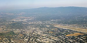
Silicon Valley
Technology hub in California, United States
Distance: Approx. 1745 meters
Latitude and longitude: 37.3775,-122.0675
Silicon Valley is a region in Northern California that is a global center for high technology and innovation. Located in the southern part of the San Francisco Bay Area, it corresponds roughly to the geographical area of the Santa Clara Valley. The term "Silicon Valley" refers to the area in which high-tech business has proliferated in Northern California, and it also serves as a general metonym for California's high-tech business sector.

Mountain View, California
City in California, United States
Distance: Approx. 10 meters
Latitude and longitude: 37.38611111,-122.08388889
Mountain View is a city in Santa Clara County, California, United States, part of the San Francisco Bay Area. Named for its views of the Santa Cruz Mountains, the population was 82,376 at the 2020 census. Mountain View was integral to the early history and growth of Silicon Valley, and is the location of many high technology companies.
Mozilla Foundation
American nonprofit organization
Distance: Approx. 227 meters
Latitude and longitude: 37.38792,-122.08284
The Mozilla Foundation (stylized as moz://a) is an American non-profit organization that exists to support and collectively lead the open source Mozilla project. Founded in July 2003, the organization sets the policies that govern development, operates key infrastructure and controls Mozilla trademarks and copyrights. It owns two taxable subsidiaries: the Mozilla Corporation, which employs many Mozilla developers and coordinates releases of the Mozilla Firefox web browser, and MZLA Technologies Corporation, which employs developers to work on the Mozilla Thunderbird email client and coordinate its releases.

Mountain View Center for the Performing Arts
Arts venue in Mountain View, California
Distance: Approx. 475 meters
Latitude and longitude: 37.39015,-122.0823
The Mountain View Center for the Performing Arts is located in downtown Mountain View, California. It is operated by the City of Mountain View and hosts a variety of art events. Its home theatre companies include TheatreWorks, Peninsula Youth Theatre, and Upstage Theater.
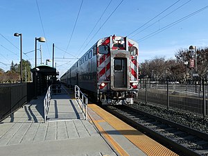
Downtown Mountain View station
Train station in Mountain View, California, U.S.
Distance: Approx. 1170 meters
Latitude and longitude: 37.394394,-122.075872
Downtown Mountain View station is an intermodal transit station providing public bus and rail service, located in Mountain View, California. The station is served by the Caltrain commuter rail service, for which it is simply called Mountain View station. Santa Clara VTA Orange Line light rail service is provided to an adjacent, dedicated light rail facility, known as Downtown Mountain View station.
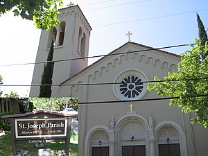
Saint Joseph Parish (Mountain View, California)
Church in California, USA
Distance: Approx. 312 meters
Latitude and longitude: 37.38814,-122.08158
Saint Joseph Parish in Mountain View, California, is a parish in the Roman Catholic Church. The parish and its church are located in Mountain View in the state of California, under the jurisdiction of the Roman Catholic Diocese of San Jose in California and its bishop. It is named after Saint Joseph, husband of Mary, the mother of Jesus; for whom the diocese and the nearby city of San Jose are also named.

Evelyn station
Distance: Approx. 1646 meters
Latitude and longitude: 37.390889,-122.066389
Evelyn station is a former VTA light rail station located in Mountain View, California. The station platform was on the then-single-track section east of Downtown Mountain View station. It was accessed via a pedestrian tunnel under the Caltrain tracks from Evelyn Avenue at the intersection with Pioneer Way.
Stream Processors, Inc.
Distance: Approx. 595 meters
Latitude and longitude: 37.38318889,-122.07835556
Stream Processors, Inc. (SPI), was a Silicon Valley–based fabless semiconductor company specializing in the design and manufacture of high-performance digital signal processors for applications including video surveillance, multi-function printers and video conferencing. The company ceased operations in 2009.

Mountain View Adobe
Multi-purpose structure in Mountain View, California
Distance: Approx. 1250 meters
Latitude and longitude: 37.39583333,-122.07694444
The Historic Adobe Building, also known as the Mountain View Adobe, is a multi-purpose structure in Mountain View, California. The building was placed on the National Register of Historic Places on October 28, 2002. The land under the structure was purchased by Mountain View in 1929 for $10 from Wallace and Alice Angelo; it was used for a pump station and reservoir and served as the town's primary water source.

Hale Creek
River in California, United States
Distance: Approx. 635 meters
Latitude and longitude: 37.38333333,-122.09027778
Hale Creek is a short stream originating in the foothills of Los Altos Hills, California in Santa Clara County, California, United States. Its source is in the Rancho San Antonio Open Space Preserve, west of Neary Quarry. The creek flows northeasterly 4.6 miles (7.4 km) through the cities of Los Altos Hills, Los Altos, and Mountain View before joining Permanente Creek.

Zume
US robot pizza and packaging company
Distance: Approx. 1428 meters
Latitude and longitude: 37.398925,-122.083925
Zume, Inc. was an American manufacturing-technology company headquartered in Camarillo, California. Founded in 2015 as an automated pizza parlor, in 2020 the company shifted to food packaging and delivery logistics.
Mountain View Academy (Mountain View, California)
Private parochial, day school in Mountain View, California, U.S.
Distance: Approx. 910 meters
Latitude and longitude: 37.3938722,-122.0871812
Mountain View Academy is a Seventh-day Adventist secondary school (grades 9–12) located in Mountain View, California. It is part of the Seventh-day Adventist education system, the world's second largest Christian school system.
Weather in this IP's area
clear sky
14 Celsius
14 Celsius
12 Celsius
16 Celsius
1011 hPa
90 %
1011 hPa
1008 hPa
10000 meters
0.52 m/s
1 m/s
331 degree
06:45:11
19:26:46