Country:
 USA
USARegion:
City:
Latitude and Longitude:
Time Zone:
Postal Code:
IP information under different IP Channel
ip-api
Country
Region
City
ASN
Time Zone
ISP
Blacklist
Proxy
Latitude
Longitude
Postal
Route
IPinfo
Country
Region
City
ASN
Time Zone
ISP
Blacklist
Proxy
Latitude
Longitude
Postal
Route
MaxMind
Country
Region
City
ASN
Time Zone
ISP
Blacklist
Proxy
Latitude
Longitude
Postal
Route
Luminati
Country
USASN
Time Zone
America/Chicago
ISP
INTERNAP-2BLK
Latitude
Longitude
Postal
db-ip
Country
Region
City
ASN
Time Zone
ISP
Blacklist
Proxy
Latitude
Longitude
Postal
Route
ipdata
Country
Region
City
ASN
Time Zone
ISP
Blacklist
Proxy
Latitude
Longitude
Postal
Route
Popular places and events near this IP address

Onizuka Air Force Station
Military space communications and satellite testing site in Sunnyvale, California
Distance: Approx. 1622 meters
Latitude and longitude: 37.40486111,-122.02875
Onizuka Air Force Station or Onizuka AFS was a United States Air Force installation in Sunnyvale, California, at the intersection of State Route 237 and North Mathilda Avenue. It operated from 1960 to 2010. One of its distinguishing feature was Building 1003, known locally as the Blue Cube and the "Cube" given its shape, color, and lack of windows.
Sunnyvale ESL shooting
Mass shooting in Sunnyvale, California, United States
Distance: Approx. 415 meters
Latitude and longitude: 37.4114,-122.0124
On February 16, 1988, a mass shooting occurred at the headquarters of ESL Incorporated in Sunnyvale, California, United States. 39-year-old Richard Farley shot and killed seven people and wounded four others. A former employee of the company, he stalked his co-worker Laura Black for four years beginning in 1984.

Moffett Park station
VTA light rail station in Sunnyvale, California
Distance: Approx. 2105 meters
Latitude and longitude: 37.402444,-122.033333
Moffett Park station is a light rail station operated by Santa Clara Valley Transportation Authority (VTA), located in Sunnyvale, California. Moffett Park was built as an infill station. This station is served by the Orange Line of the VTA light rail system.
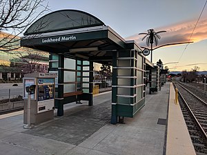
Lockheed Martin Transit Center
VTA light rail station in Sunnyvale, California
Distance: Approx. 1215 meters
Latitude and longitude: 37.409556,-122.02725
Lockheed Martin Transit Center (signed as simply Lockheed Martin station on many signs) is a light rail and transit bus station operated by Santa Clara Valley Transportation Authority (VTA), located in Sunnyvale, California. This station is served by the Orange Line of the VTA light rail system. The land for the transit center was donated by Lockheed Martin during the planning of VTA's Tasman West light rail extension.

Borregas station
VTA light rail station in Sunnyvale, California
Distance: Approx. 415 meters
Latitude and longitude: 37.41166667,-122.01805556
Borregas station is a light rail station operated by Santa Clara Valley Transportation Authority (VTA), located in Sunnyvale, California. This station is served by the Orange Line of the VTA light rail system. The station is located in an industrial area; nearby offices include the headquarters of Infinera and Ruckus Networks.
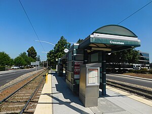
Crossman station
VTA light rail station in Sunnyvale, California
Distance: Approx. 674 meters
Latitude and longitude: 37.40916667,-122.01138889
Crossman station is a light rail station operated by Santa Clara Valley Transportation Authority (VTA), located in Sunnyvale, California. This station is served by the Orange Line of the VTA light rail system. It is located in an industrial area; nearby buildings include the headquarters of NetApp.

Fair Oaks station
VTA light rail station in Sunnyvale, California
Distance: Approx. 1403 meters
Latitude and longitude: 37.40277778,-122.00916667
Fair Oaks station is a light rail station operated by Santa Clara Valley Transportation Authority (VTA), located in Sunnyvale, California. This station is served by the Orange Line of the VTA light rail system.
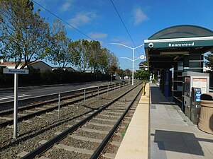
Reamwood station
VTA light rail station in Sunnyvale, California
Distance: Approx. 674 meters
Latitude and longitude: 37.40916667,-122.01138889
Reamwood station is a light rail station operated by Santa Clara Valley Transportation Authority (VTA), located in Sunnyvale, California. This station is served by the Orange Line of the VTA light rail system.
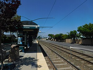
Vienna station (VTA)
VTA light rail station in Sunnyvale, California
Distance: Approx. 674 meters
Latitude and longitude: 37.40916667,-122.01138889
Vienna station is a light rail station operated by Santa Clara Valley Transportation Authority (VTA) in Sunnyvale, California. This station is served by the Orange Line of the VTA light rail system. No bus connections are available at this location.

John W. Christian Greenbelt
Distance: Approx. 1833 meters
Latitude and longitude: 37.399,-122.022
The John W. Christian Greenbelt is a stretch of green land in northern Sunnyvale, California.

Saratoga Creek
River in California, United States
Distance: Approx. 2426 meters
Latitude and longitude: 37.41722222,-121.98777778
Saratoga Creek is a north-northeast flowing creek in Santa Clara County, California.

Calabazas Creek (Santa Clara County)
River in California, United States
Distance: Approx. 2450 meters
Latitude and longitude: 37.41722222,-121.9875
Calabazas Creek is a 13.3-mile-long (21.4 km) northeast by northward-flowing stream originating on Table Mountain in Saratoga, California in Santa Clara County, California, United States. It courses through the cities of Saratoga, San Jose, Cupertino, Santa Clara and Sunnyvale, culminating in the Guadalupe Slough in south San Francisco Bay.
Weather in this IP's area
clear sky
15 Celsius
15 Celsius
12 Celsius
17 Celsius
1011 hPa
89 %
1011 hPa
1011 hPa
10000 meters
06:44:54
19:26:31