Country:
 USA
USARegion:
City:
Latitude and Longitude:
Time Zone:
Postal Code:
IP information under different IP Channel
ip-api
Country
Region
City
ASN
Time Zone
ISP
Blacklist
Proxy
Latitude
Longitude
Postal
Route
IPinfo
Country
Region
City
ASN
Time Zone
ISP
Blacklist
Proxy
Latitude
Longitude
Postal
Route
MaxMind
Country
Region
City
ASN
Time Zone
ISP
Blacklist
Proxy
Latitude
Longitude
Postal
Route
Luminati
Country
USASN
Time Zone
America/Chicago
ISP
INTERNAP-2BLK
Latitude
Longitude
Postal
db-ip
Country
Region
City
ASN
Time Zone
ISP
Blacklist
Proxy
Latitude
Longitude
Postal
Route
ipdata
Country
Region
City
ASN
Time Zone
ISP
Blacklist
Proxy
Latitude
Longitude
Postal
Route
Popular places and events near this IP address
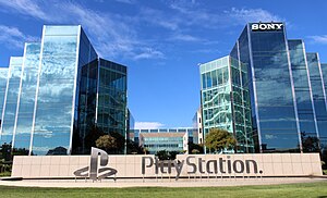
Sony Interactive Entertainment
Sony's video game division
Distance: Approx. 1092 meters
Latitude and longitude: 37.56055556,-122.28416667
Sony Interactive Entertainment LLC (SIE) is an American multinational video game and digital entertainment company based in San Mateo, California, and a subsidiary of Sony Group Corporation. Jointly established by two subsidiaries in 2016, it primarily operates the PlayStation brand of video game consoles and products. It is also the world's largest company in the video game industry based on its equity investments.
Bay Meadows Racetrack
Auto and horse racing track in San Mateo, California
Distance: Approx. 1171 meters
Latitude and longitude: 37.543361,-122.297739
Bay Meadows was a horse racing track in San Mateo, California from 1934 until 2008, in the San Francisco Bay Area in the United States.
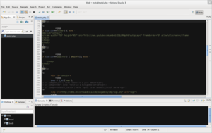
Aptana
Text editor
Distance: Approx. 561 meters
Latitude and longitude: 37.556588,-122.287681
Aptana, Inc. is a company that makes web application development tools for use with a variety of programming languages (such as JavaScript, Ruby, PHP and Python). Aptana's main products include Aptana Studio, Aptana Cloud and Aptana Jaxer.

Leo J. Ryan Memorial Park
Distance: Approx. 1791 meters
Latitude and longitude: 37.55856,-122.27153
Leo J. Ryan Memorial Park is a recreational city park, located in Foster City, California and run by the city government and local citizens. Originally called "Central Park", the park was renamed in 1979 in honor and memory of Congressman Leo J. Ryan. The park is situated on 20 acres (8 ha) which overlook Foster City's lagoon.

Hillsdale station (Caltrain)
Train station in San Mateo, California, U.S.
Distance: Approx. 1480 meters
Latitude and longitude: 37.54194444,-122.30111111
Hillsdale station is one of three Caltrain stations in San Mateo, California. The station is next to the Bay Meadows neighborhood and close to the Hillsdale Shopping Center.

Hayward Park station
Train station in San Mateo, California, U.S.
Distance: Approx. 1723 meters
Latitude and longitude: 37.55333333,-122.30944444
Hayward Park station is one of three Caltrain stations in San Mateo, California. It is located just to the north of the State Route 92 overcrossing, about 1,200 ft (370 m) south of the site of the original Southern Pacific station in Hayward Park (known as Leslie Station prior to 1936). It was relocated in 1999 because of a lack of parking at the original site, and because the previous station had been sited along a curve in the tracks near 16th Avenue.
San Mateo-Foster City School District
School district in California
Distance: Approx. 1632 meters
Latitude and longitude: 37.55,-122.30833333
San Mateo-Foster City School District is a school district in San Mateo and Foster City, California. It consists of twenty schools: three middle schools (Grades 6–8), fourteen elementary schools (TK/K–5), and three schools with all grades (K–8). With a total enrollment of approximately 12,500 students (in 2015–16), it is the largest school district in San Mateo County.

Peninsula Library System
Distance: Approx. 1715 meters
Latitude and longitude: 37.544342,-122.306928
The Peninsula Library System (PLS) is a consortium of public and community college libraries in San Mateo County, California, United States, which serves the part of the San Francisco Bay Area known as "The Peninsula". The system has dozens of branches in local communities and at various area community colleges, a bookmobile, and automated book kiosks called Library-a-Go-Go.
Japan Expo USA
Distance: Approx. 1194 meters
Latitude and longitude: 37.54611111,-122.30138889
Japan Expo USA was a three-day anime convention held in August at the San Mateo Event Center in San Mateo, California, United States. The convention was organized by SEFA Entertainment, based in San Francisco, California. It was the American subsidiary of the JTS Group, the organizing group of Japan Expo in Paris, France.
Bay Meadows (neighborhood)
Neighborhood in San Mateo, CA, US
Distance: Approx. 1171 meters
Latitude and longitude: 37.543361,-122.297739
Bay Meadows is an 83-acre mixed-use, transit-oriented development in the City of San Mateo, California. The neighborhood is divided into station/mixed-use and residential districts, which are further divided into 18 development blocks. The station/mixed-use district is primarily adjacent to Delaware Street, the major north–south street through the neighborhood.
Gurnick Academy
Private medical school in California
Distance: Approx. 1674 meters
Latitude and longitude: 37.54722,-122.30802
Gurnick Academy (also known as Gurnick Academy of Medical Arts) is a private for-profit higher-education institution in California providing nursing, imaging and allied health programs. The school’s corporate office is located in San Jose, California, and it operates six campuses, in San Jose, Concord, Modesto, Fresno, Sacramento and Los Angeles, as well as offering distance education online. The academy is operated and owned by the Gurnick Academy of Medical Arts, with Konstantin Gourji as the chief executive officer.
Bridgepointe Shopping Center
Shopping mall in California, U.S.
Distance: Approx. 1153 meters
Latitude and longitude: 37.5599,-122.2817
Bridgepointe Shopping Center is a shopping mall in San Mateo, California, United States. Opened in 1982 as San Mateo Fashion Island, it was originally an enclosed shopping mall featuring JCPenney, Bullock's, Liberty House, and Montgomery Ward as its anchor stores. Following the closures of Bullock's and Liberty House, the mall went into decline throughout the 1990s, leading to its closure and demolition in favor of a power center.
Weather in this IP's area
clear sky
13 Celsius
13 Celsius
12 Celsius
16 Celsius
1011 hPa
91 %
1011 hPa
1011 hPa
10000 meters
2.06 m/s
06:45:54
19:27:42