63.250.106.208 - IP Lookup: Free IP Address Lookup, Postal Code Lookup, IP Location Lookup, IP ASN, Public IP
Country:
Region:
City:
Location:
Time Zone:
Postal Code:
ISP:
ASN:
language:
User-Agent:
Proxy IP:
Blacklist:
IP information under different IP Channel
ip-api
Country
Region
City
ASN
Time Zone
ISP
Blacklist
Proxy
Latitude
Longitude
Postal
Route
db-ip
Country
Region
City
ASN
Time Zone
ISP
Blacklist
Proxy
Latitude
Longitude
Postal
Route
IPinfo
Country
Region
City
ASN
Time Zone
ISP
Blacklist
Proxy
Latitude
Longitude
Postal
Route
IP2Location
63.250.106.208Country
Region
ontario
City
mississauga
Time Zone
America/Toronto
ISP
Language
User-Agent
Latitude
Longitude
Postal
ipdata
Country
Region
City
ASN
Time Zone
ISP
Blacklist
Proxy
Latitude
Longitude
Postal
Route
Popular places and events near this IP address
Paramount Fine Foods Centre
Arena in Mississauga, Ontario
Distance: Approx. 2011 meters
Latitude and longitude: 43.6323,-79.6535
The Paramount Fine Foods Centre, formerly the Hershey Centre, is a multi-purpose sports and entertainment complex located in Mississauga, Ontario, Canada. Its current name was adopted on July 1, 2018, following a new naming rights agreement with Mississauga-based restaurant chain Paramount Fine Foods.

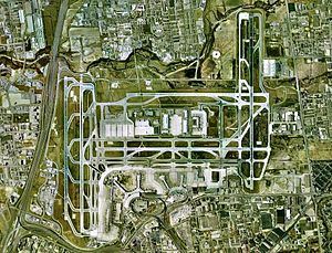
Toronto Pearson International Airport
Airport in Malton, Ontario, Canada
Distance: Approx. 3835 meters
Latitude and longitude: 43.67666667,-79.63055556
Toronto Pearson International Airport (IATA: YYZ, ICAO: CYYZ) is an international airport located in Mississauga, with a small portion of the airfield, along Silver Dart Drive north of Renforth Drive, extending into Toronto's western district of Etobicoke, Ontario, Canada. It is the main airport serving Toronto, its metropolitan area, and the surrounding region known as the Golden Horseshoe. The airport is named in honour of Lester B. Pearson, who served as the 14th Prime Minister of Canada (1963–1968) and received the Nobel Peace Prize in 1957 for his humanitarian work in peacekeeping.

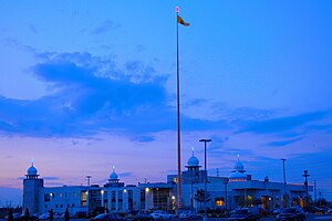
Ontario Khalsa Darbar
Gurdwara in Mississauga, Ontario
Distance: Approx. 3314 meters
Latitude and longitude: 43.6767,-79.67754
The Ontario Khalsa Darbar, popularly referred to as Dixie Gurdwara, is a Sikh Gurdwara (place of worship) in Mississauga, Ontario. One of the few Sikh Gurdwara in Canada, it attracts hundreds of celebrants for major religious festivals. A gurdwara, meaning "the doorway to the Guru", is the Sikh place of worship and may be referred to as a Sikh temple.

Air France Flight 358
2005 runway excursion accident in Canada
Distance: Approx. 2954 meters
Latitude and longitude: 43.65644444,-79.62472222
Air France Flight 358 was a regularly scheduled international flight from Charles de Gaulle Airport in Paris, France, to Toronto Pearson International Airport in Ontario, Canada. On the afternoon of 2 August 2005, while landing at Pearson airport, the Airbus A340-313E operating the route overran the runway and crashed into nearby Etobicoke Creek, approximately 300 m (980 ft) beyond the end of the runway. All 309 passengers and crew on board the Airbus survived, but twelve people sustained serious injuries.

Air Canada Flight 189
1978 plane crash of an Air Canada DC-9-32
Distance: Approx. 3005 meters
Latitude and longitude: 43.65972222,-79.62555556
Air Canada Flight 189 was an Air Canada flight from Ottawa to Vancouver via Toronto and Winnipeg. On June 26, 1978, the McDonnell Douglas DC-9 operating the flight crashed on takeoff in Toronto, killing two passengers.

Philip Pocock Catholic Secondary School
Catholic high school in Mississauga, Ontario, Canada
Distance: Approx. 3893 meters
Latitude and longitude: 43.625,-79.626
Philip Pocock Catholic Secondary School (alternatively called as Philip Pocock, PPCSS, PP, Philip Pocock CSS, or Pocock) is a Roman Catholic high school in Mississauga, Ontario, Canada. It is operated by the Dufferin-Peel Catholic District School Board and has approximately 1,350 students. The school includes an Extended French Program as well as an Advanced Placement Program for Mathematics and the Sciences (Biology, Physics, Chemistry).
CINA (AM)
Multicultural radio station in Mississauga, Ontario
Distance: Approx. 3566 meters
Latitude and longitude: 43.62555556,-79.63111111
CINA (1650 kHz) is a commercial AM radio station, licensed to Mississauga, Ontario, Canada and serving the Greater Toronto area. It broadcasts a South Asian format of talk radio, all-news radio and music shows. It is owned by Neeti Prakash Ray, who co-owns a sister station in Windsor, CINA-FM. By day, CINA is powered at 5,000 watts; however, to protect other stations from interference, at night it reduces power to 680 watts.
Baitul Hamd Mosque (Mississauga)
Mosque in Ontario, Canada
Distance: Approx. 2332 meters
Latitude and longitude: 43.63722222,-79.63694444
The Baitul Hamd Mosque (Urdu: بیت الحمد, lit. 'House of Praise') is an Ahmadiyy mosque in Mississauga, Ontario, in Canada. The mosque is run by the Ahmadiyya Muslim Community Canada (AMJ). In 1999, the AMJ purchased the building from Trinity Club House.
Toronto Area Control Centre
Airport
Distance: Approx. 3597 meters
Latitude and longitude: 43.67159683,-79.62736083
Toronto Area Control Center (ICAO: CZYZ) is one of seven area control centers in Canada operated by Nav Canada. The Toronto Area Control Centre is based near Toronto Pearson International Airport in Mississauga, Ontario. From the Toronto Area Control Centre, air traffic controllers provide en route and terminal control services to aircraft in the Toronto Flight Information Region (FIR).

Mississauga—Malton (federal electoral district)
Federal electoral district in Ontario, Canada
Distance: Approx. 590 meters
Latitude and longitude: 43.655,-79.66
Mississauga—Malton is a federal electoral district in Ontario. It encompasses a portion of Ontario previously included in the electoral districts of Bramalea—Gore—Malton, Mississauga—Brampton South and Mississauga—Streetsville. Mississauga—Malton was created by the 2012 federal electoral boundaries redistribution and was legally defined in the 2013 representation order.

Mississauga—Malton (provincial electoral district)
Provincial electoral district in Ontario, Canada
Distance: Approx. 590 meters
Latitude and longitude: 43.655,-79.66
Mississauga—Malton is a provincial electoral district in Ontario, Canada. It elects one member to the Legislative Assembly of Ontario. This riding was created in 2015.

Toronto Pearson International Airport heist
2023 Canadian heist
Distance: Approx. 3835 meters
Latitude and longitude: 43.67666667,-79.63055556
On April 17, 2023, a major theft occurred at Toronto Pearson International Airport in Canada, with over C$20 million (US$15 million) worth of gold and cash in foreign currency being stolen. In the evening of Monday, April 17, a container which contained goldbars and foreign currency was offloaded off an inbound aircraft and transferred to an Air Canada holding facility at the airport where Air Canada staff were tricked by a forged shipping document to load it onto a getaway truck. Nine people have been charged in relation to the heist.
Weather in this IP's area
overcast clouds
-12 Celsius
-19 Celsius
-12 Celsius
-10 Celsius
1027 hPa
63 %
1027 hPa
1004 hPa
10000 meters
4.63 m/s
200 degree
100 %
