Country:
 USA
USARegion:
City:
Latitude and Longitude:
Time Zone:
Postal Code:
IP information under different IP Channel
ip-api
Country
Region
City
ASN
Time Zone
ISP
Blacklist
Proxy
Latitude
Longitude
Postal
Route
IPinfo
Country
Region
City
ASN
Time Zone
ISP
Blacklist
Proxy
Latitude
Longitude
Postal
Route
MaxMind
Country
Region
City
ASN
Time Zone
ISP
Blacklist
Proxy
Latitude
Longitude
Postal
Route
Luminati
Country
USRegion
md
City
silverspring
ASN
Time Zone
America/New_York
ISP
Ses Astra S.A.
Latitude
Longitude
Postal
db-ip
Country
Region
City
ASN
Time Zone
ISP
Blacklist
Proxy
Latitude
Longitude
Postal
Route
ipdata
Country
Region
City
ASN
Time Zone
ISP
Blacklist
Proxy
Latitude
Longitude
Postal
Route
Popular places and events near this IP address

Maryland
U.S. state
Distance: Approx. 1896 meters
Latitude and longitude: 39,-77
Maryland (US: MERR-il-ənd) is a state in the Mid-Atlantic region of the United States. It borders Virginia to its south, West Virginia to its west, Pennsylvania to its north, Delaware and the Atlantic Ocean to its east, and the national capital of Washington, D.C. to the southwest. With a total area of 12,407 square miles (32,130 km2), Maryland is the ninth-smallest state by land area, and its population of 6,177,224 ranks it the 18th-most populous state and the fifth-most densely populated.

Montgomery Blair High School
Public (magnet) high school in Silver Spring, Maryland, United States
Distance: Approx. 362 meters
Latitude and longitude: 39.01805556,-77.01138889
Montgomery Blair High School (MBHS) is a public high school in the Four Corners neighborhood of Silver Spring, Maryland, United States. It is operated by Montgomery County Public Schools. Its enrollment of 3,204 makes it the largest school in Montgomery County and in the state.

Maryland's 4th congressional district
U.S. House district for Maryland
Distance: Approx. 1753 meters
Latitude and longitude: 39.03,-77
Maryland's 4th congressional district wraps around the eastern edge of Washington, D.C., taking in most of Prince George's County and a small portion of Montgomery County. It is home to several racially diverse middle-class suburbs, including College Park, Fort Washington, Greenbelt, and Laurel. With a median household income of $86,941, it is the wealthiest black-majority district in the United States.
WBQH
Radio station in Maryland, United States
Distance: Approx. 1823 meters
Latitude and longitude: 39.01388889,-77.02944444
WBQH (1050 AM) is a radio broadcasting station in the Washington, D.C. region, licensed to Silver Spring, Maryland. It broadcasts a regional Mexican format. It is owned by Hubbard Broadcasting, and is leased to United Media Group LLC. WBQH programming is heard on FM translator W228DI (93.5), also in Silver Spring.
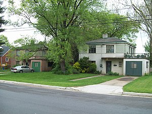
Polychrome Historic District
Historic house in Maryland, United States
Distance: Approx. 686 meters
Latitude and longitude: 39.01805556,-77.01583333
The Polychrome Historic District is a national historic district in the Four Corners neighborhood in Silver Spring, Montgomery County, Maryland. It recognizes a group of five houses built by John Joseph Earley in 1934 and 1935. Earley used precast concrete panels with brightly colored aggregate to produce the polychrome effect, with Art Deco details.

Woodmoor, Maryland
Neighborhood of Silver Spring, Maryland, US
Distance: Approx. 893 meters
Latitude and longitude: 39.02305,-77.004375
Woodmoor is a neighborhood in the northern section of Silver Spring, Maryland in southeastern Montgomery County, in the U.S. state of Maryland. Its borders extend from U.S. 29 to the west, Northwest Branch Park to the north, the Capital Beltway (I-95) to the east, and University Boulevard to the south. It lies on one of the "Four Corners" at the northeastern corner of the intersection of Colesville Road (U.S. 29), and University Boulevard (Maryland 193).

Four Corners, Maryland
Neighborhood in Montgomery County, Maryland, United States
Distance: Approx. 738 meters
Latitude and longitude: 39.02222222,-77.00694444
Four Corners is a neighborhood and census-designated place (CDP) in Montgomery County, Maryland, United States. Many residents consider the neighborhood a part of Silver Spring, to whose CDP it belonged until 2010. It had a population of 8,316 at the 2020 census.

Dale Drive station
Future light rail station in Maryland
Distance: Approx. 1832 meters
Latitude and longitude: 38.9999464,-77.014645
Dale Drive is a light rail station currently under construction. It will be part of the Purple Line in Maryland. The station will be located at the intersection of Dale Drive and Wayne Avenue, adjacent to Silver Spring International Middle School.
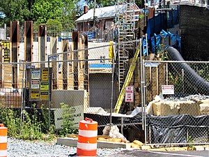
Manchester Place station
Distance: Approx. 1626 meters
Latitude and longitude: 39.0011,-77.0078
Manchester Place is a light rail station that is currently under construction. It will be part of the Purple Line in Maryland. The station will be located underground in between Wayne Avenue and Plymouth Street.

Franklin Knolls (Silver Spring, Maryland)
Neighborhood
Distance: Approx. 934 meters
Latitude and longitude: 39.014832,-76.997754
Franklin Knolls is a residential neighborhood located in Silver Spring, a census-designated place in Montgomery County.

Indian Spring
Neighborhood
Distance: Approx. 499 meters
Latitude and longitude: 39.012448,-77.012469
Indian Spring (also known as Indian Spring Terrace) is a mostly residential neighborhood of Silver Spring, Maryland. Located within the Silver Spring CDP, it is sometimes considered a southeastern neighborhood of Four Corners. It is one of the oldest established neighborhoods in Silver Spring.
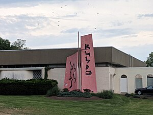
Temple Israel (Silver Spring, Maryland)
Former synagogue, now church in Silver Spring, Maryland, United States
Distance: Approx. 1230 meters
Latitude and longitude: 39.0087209,-76.9974763
Temple Israel is a former Conservative Jewish congregation and synagogue, located at 420 University Boulevard East, in the neighborhood of Montgomery Knolls, in Silver Spring, Maryland, in the United States. The congregation was established in 1951, the building was completed in 1952 and operated as a synagogue until 1997; when it was subsequently repurposed as the Mount Jezreel Baptist Church, a Baptist church building.
Weather in this IP's area
clear sky
11 Celsius
10 Celsius
9 Celsius
13 Celsius
1017 hPa
85 %
1017 hPa
1005 hPa
10000 meters
06:43:41
19:27:46