Country:
Region:
City:
Latitude and Longitude:
Time Zone:
Postal Code:
IP information under different IP Channel
ip-api
Country
Region
City
ASN
Time Zone
ISP
Blacklist
Proxy
Latitude
Longitude
Postal
Route
Luminati
Country
Region
ca
City
vallejo
ASN
Time Zone
America/Los_Angeles
ISP
SCOE-ASN-25664
Latitude
Longitude
Postal
IPinfo
Country
Region
City
ASN
Time Zone
ISP
Blacklist
Proxy
Latitude
Longitude
Postal
Route
db-ip
Country
Region
City
ASN
Time Zone
ISP
Blacklist
Proxy
Latitude
Longitude
Postal
Route
ipdata
Country
Region
City
ASN
Time Zone
ISP
Blacklist
Proxy
Latitude
Longitude
Postal
Route
Popular places and events near this IP address
KHGE
Radio station in Fresno, California
Distance: Approx. 9369 meters
Latitude and longitude: 36.819,-119.51
KHGE (102.7 FM, "102.7 The Wolf") is a commercial country radio station in Fresno, California, owned and operated by iHeartMedia. Its studios are located on Shaw Avenue in North Fresno, and the transmitter tower is east of Clovis. KHGE broadcasts two channels in HD. The HD-2 channel was known as "Salsa Bembé", with dance music in Spanish.
Centerville, Fresno County, California
Census-designated place in California, United States
Distance: Approx. 8664 meters
Latitude and longitude: 36.73388889,-119.49777778
Centerville (formerly, Kings River, King River, Scottsburgh, and Scottsburg) is a census-designated place in Fresno County, California. It is located on the Atchison, Topeka and Santa Fe Railroad 16 miles (26 km) east of Fresno, at an elevation of 394 feet (120 m). At the 2010 census, it had a population of 392.

Minkler, California
Census-designated place in California, United States
Distance: Approx. 7032 meters
Latitude and longitude: 36.72388889,-119.45805556
Minkler is a census-designated place in eastern Fresno County, California, United States. The place is located on Highway 180, 2.25 miles (3.6 km) east-southeast of Centerville and 7.6 miles north of Reedley at an elevation of 397 feet (121 m). It has a population of 1,003 people.
Piedra, California
Unincorporated community in California, United States
Distance: Approx. 4796 meters
Latitude and longitude: 36.81027778,-119.38194444
Piedra (Spanish for "Stone") is an unincorporated community in Fresno County, California. It is located on the south bank of the Kings River 23 miles (37 km) east of Fresno, at an elevation of 538 feet (164 m).
Tisechu, California
Distance: Approx. 8078 meters
Latitude and longitude: 36.8237,-119.3473
Tisechu (also, Tis-e-chu and Tishech) is a former Choinimni settlement in Fresno County, California. It was located at the confluence of Kings River and Mill Creek. The Choinimni were a branch of the Yokuts people.

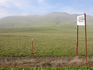
Jesse Morrow Mountain
Mountain in California, United States
Distance: Approx. 4783 meters
Latitude and longitude: 36.7360608,-119.4081809
Jesse Morrow Mountain is located in Fresno County, California. In December 2012, construction company Cemex agreed not to pursue mining operations which would turn much of the mountain into gravel for building projects.
Stoner House
United States historic place
Distance: Approx. 1736 meters
Latitude and longitude: 36.764606,-119.408684
The Stoner House, in Fresno County, California near Sanger, California, was built in 1910. It was listed on the National Register of Historic Places in 1985. The listing included two contributing buildings (a house and a barn) on 19.7 acres (8.0 ha).

Mount Campbell (California)
Mountain summit in California
Distance: Approx. 9026 meters
Latitude and longitude: 36.697222,-119.419167
Mount Campbell is an isolated mountain summit in the Sierra Nevada foothills, located in Fresno County, California. It is located in the center of a circle formed by the cities of Reedley (five miles to the south), Parlier (eight miles to the southwest), Sanger (seven miles to the west), Piedra (eight miles to the north), and Orange Cove (seven miles to the southeast). CA 180 runs across between Mount Campbell and the rest of the Sierra Nevada foothills.
Weather in this IP's area
clear sky
22 Celsius
21 Celsius
20 Celsius
23 Celsius
1014 hPa
21 %
1014 hPa
997 hPa
10000 meters
06:30:15
16:52:58