Country:
Region:
City:
Latitude and Longitude:
Time Zone:
Postal Code:
IP information under different IP Channel
ip-api
Country
Region
City
ASN
Time Zone
ISP
Blacklist
Proxy
Latitude
Longitude
Postal
Route
IPinfo
Country
Region
City
ASN
Time Zone
ISP
Blacklist
Proxy
Latitude
Longitude
Postal
Route
MaxMind
Country
Region
City
ASN
Time Zone
ISP
Blacklist
Proxy
Latitude
Longitude
Postal
Route
Luminati
Country
Region
nj
City
lincolnpark
ASN
Time Zone
America/New_York
ISP
MORRISBB
Latitude
Longitude
Postal
db-ip
Country
Region
City
ASN
Time Zone
ISP
Blacklist
Proxy
Latitude
Longitude
Postal
Route
ipdata
Country
Region
City
ASN
Time Zone
ISP
Blacklist
Proxy
Latitude
Longitude
Postal
Route
Popular places and events near this IP address

Lincoln Park, New Jersey
Populated place in Morris County, New Jersey, US
Distance: Approx. 887 meters
Latitude and longitude: 40.923751,-74.304235
Lincoln Park is a borough in Morris County, in the U.S. state of New Jersey. As of the 2020 United States census, the borough's population was 10,915, an increase of 394 (+3.7%) from the 2010 census count of 10,521, which in turn reflected a decline of 409 (−3.7%) from the 10,930 counted in the 2000 census. Lincoln Park was incorporated as a borough by an act of the New Jersey Legislature on March 11, 1922, from portions of Pequannock Township.

Lincoln Park Airport
Airport in Morris County, New Jersey
Distance: Approx. 3377 meters
Latitude and longitude: 40.9475,-74.31444444
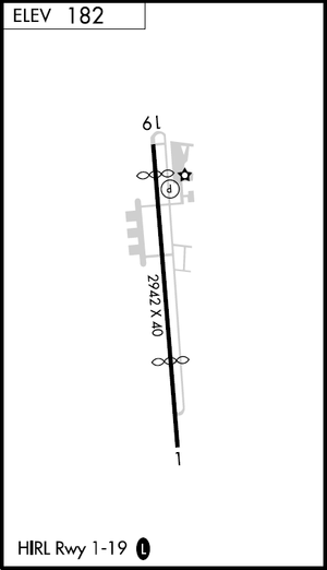
Lincoln Park Airport (FAA LID: N07) is a privately owned, public use airport located two nautical miles (4 km) north of the central business district of Lincoln Park, in Morris County, New Jersey, United States. It is included in the National Plan of Integrated Airport Systems for 2019–2023, which categorized it as a general aviation reliever airport.
Packanack Lake, New Jersey
Populated place in Passaic County, New Jersey, US
Distance: Approx. 3960 meters
Latitude and longitude: 40.9425,-74.25638889
Packanack Lake is an unincorporated lake community and census-designated place (CDP) in Wayne in Passaic County, in the U.S. state of New Jersey. The community is located 30 minutes northwest of Manhattan. The median income in Packanack Lake was $100,887, and the average income of households with children was $140,869.

Wayne Route 23 Transit Center
NJ Transit rail station
Distance: Approx. 4034 meters
Latitude and longitude: 40.8993,-74.2561
The Wayne Route 23 Transit Center is a mass transportation hub located in Wayne, New Jersey, USA. Operated by NJ Transit, the complex consists of two major components. One is a bus terminal that provides service to Port Authority Bus Terminal, Newark Penn Station, and intermediate points in the surrounding area. The other is a train platform that is connected to the Montclair-Boonton Line and offers service to Hoboken Terminal, connecting service to New York Penn Station, and local service to points between Montclair State University and Hackettstown.

Mountain View station (NJ Transit)
NJ Transit rail station
Distance: Approx. 2393 meters
Latitude and longitude: 40.91388889,-74.2675
Mountain View, signed on the platform as Mountain View–Wayne, is a station on the Montclair-Boonton Line of NJ Transit in Wayne, New Jersey. Prior to the Montclair Connection in 2002, the station was served by the Boonton Line. The station is located on Erie Avenue, just off of US 202 and Route 23 in Downtown Wayne.
Lincoln Park station
NJ Transit rail station
Distance: Approx. 746 meters
Latitude and longitude: 40.92416667,-74.30222222
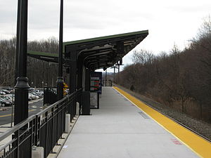
Lincoln Park is a station on NJ Transit's Montclair-Boonton Line in the borough of Lincoln Park, Morris County, New Jersey. The station is located near the Comly Road overpass, accessible from Main Street, Station Road and Park Avenue.
Lincoln Park Public Schools (New Jersey)
School district in Morris County, New Jersey, US
Distance: Approx. 1551 meters
Latitude and longitude: 40.935125,-74.296512
The Lincoln Park Public Schools are a community public school district that serves students in pre-kindergarten through eighth grade from Lincoln Park, in Morris County, in the U.S. state of New Jersey. As of the 2018–19 school year, the district, comprising two schools, had an enrollment of 914 students and 82.4 classroom teachers (on an FTE basis), for a student–teacher ratio of 11.1:1. The district is classified by the New Jersey Department of Education as being in District Factor Group "FG", the fourth-highest of eight groupings.
Great Piece Meadows
Distance: Approx. 3207 meters
Latitude and longitude: 40.89665,-74.31393
Great Piece Meadows is a 7,100-acre (29 km2) fresh water swamp located in the towns of Lincoln Park, Montville, and Fairfield in New Jersey. The wooded swamp is mostly inside the bow of the Passaic River which floods during the year from heavy rain or heavy snow melt. The meadows are part of the Northeastern coastal forests ecoregion.
Terhune Benjamin House
Building in New Jersey, U.S.
Distance: Approx. 1490 meters
Latitude and longitude: 40.9238,-74.3116
The Terhune Benjamin House was a historic farm and a former mill site located in Lincoln Park, New Jersey.

Lincoln Park History Museum
Historic site in Lincoln Park, New Jersey, United States
Distance: Approx. 1502 meters
Latitude and longitude: 40.9230428,-74.3119051
The Lincoln Park History Museum is an early-20th-century library and historic site located between U.S. Route 202 and the Morris Canal in Lincoln Park, New Jersey. It was built in 1927 as a public library serving the citizens of rural Lincoln Park. Since its decommissioning, it has served a different role as a history museum with exhibits about Lincoln Park, the Morris Canal, and New Jersey.

Mountain View station (Delaware, Lackawanna and Western Railroad)
Distance: Approx. 2990 meters
Latitude and longitude: 40.91355556,-74.26016667
Mountain View was a station on the Boonton Branch of the Delaware, Lackawanna and Western Railroad. Located in the Mountain View section of Wayne Township, New Jersey, the station was at the Parish Drive bridge over the tracks. The station was 20.8 miles (33.5 km) away from its terminus at Hoboken Terminal on the shores of the Hudson River, where connections would be made to New York City via ferry and the Hudson and Manhattan Railroad.

John Dods House and Tavern
United States historic place
Distance: Approx. 760 meters
Latitude and longitude: 40.91777778,-74.30194444
John Dods House and Tavern are located in the borough of Lincoln Park in Morris County, New Jersey, United States. The house, located at 11 Highland Street, was built in the early 1700s and the tavern, located at 8 Chapel Hill Road, was built around 1770. They were added to the National Register of Historic Places on August 12, 1977, for their significance in social history and transportation.
Weather in this IP's area
clear sky
25 Celsius
26 Celsius
23 Celsius
27 Celsius
1011 hPa
62 %
1011 hPa
1005 hPa
10000 meters
2.57 m/s
30 degree
06:42:10
18:59:32
