Country:
 USA
USARegion:
City:
Latitude and Longitude:
Time Zone:
Postal Code:
IP information under different IP Channel
ip-api
Country
Region
City
ASN
Time Zone
ISP
Blacklist
Proxy
Latitude
Longitude
Postal
Route
IPinfo
Country
Region
City
ASN
Time Zone
ISP
Blacklist
Proxy
Latitude
Longitude
Postal
Route
MaxMind
Country
Region
City
ASN
Time Zone
ISP
Blacklist
Proxy
Latitude
Longitude
Postal
Route
Luminati
Country
USRegion
nc
City
franklin
ASN
Time Zone
America/New_York
ISP
MORRISBB
Latitude
Longitude
Postal
db-ip
Country
Region
City
ASN
Time Zone
ISP
Blacklist
Proxy
Latitude
Longitude
Postal
Route
ipdata
Country
Region
City
ASN
Time Zone
ISP
Blacklist
Proxy
Latitude
Longitude
Postal
Route
Popular places and events near this IP address

Macon County, North Carolina
County in North Carolina, United States
Distance: Approx. 4765 meters
Latitude and longitude: 35.15,-83.42
Macon County is a county located in the U.S. state of North Carolina. As of the 2020 census, the population was 37,014. Its county seat is Franklin.
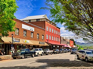
Franklin, North Carolina
Town in North Carolina, United States
Distance: Approx. 605 meters
Latitude and longitude: 35.17972222,-83.38111111
Franklin is a town in and the county seat of Macon County, North Carolina, United States. It is situated within the Nantahala National Forest. The population was reported to be 4,175 in the 2020 census, an increase from the total of 3,845 tabulated in 2010.

Cullasaja River
Stream in North Carolina, US
Distance: Approx. 1762 meters
Latitude and longitude: 35.175,-83.36972222
The Cullasaja River () is a short river located entirely in Macon County, North Carolina. It is a tributary of the Little Tennessee River into which it flows near the county seat of Franklin. (The Little Tennessee feeds the Tennessee, Ohio and Mississippi rivers.) The Cullasaja originates in the southeast, near Highlands, the county's only other town.
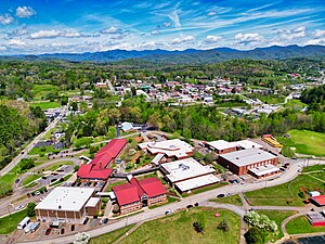
Franklin High School (North Carolina)
American public school in North Carolina
Distance: Approx. 892 meters
Latitude and longitude: 35.1765,-83.3806
Franklin High School is the largest 9th-12th grade public high school in Macon County, North Carolina. Franklin High is just parallel to downtown Franklin. It is part of the Macon County School System.
Macon Early College
American early college school in North Carolina
Distance: Approx. 2622 meters
Latitude and longitude: 35.1597,-83.3815
The Macon Early College high school is part of the early college program. It is located next to the Macon County branch of Southwestern Community College and Macon County's public library in Franklin, NC. Southwestern Community College is a partner to Macon Early College in that college courses are taken as a student of both schools. As of 2008 SCC has been ranked 4th in the list of America's best community colleges.
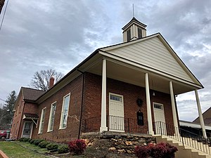
First Presbyterian Church (Franklin, North Carolina)
Historic church in North Carolina, United States
Distance: Approx. 242 meters
Latitude and longitude: 35.1825,-83.38388889
First Presbyterian Church, formerly the Franklin Presbyterian Church, is a church in Franklin, North Carolina, United States. It was built in 1856 and added to the National Register of Historic Places in 1987. In 1993, it was rewired, fitted with HVAC and given new interior walls.
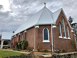
Saint Agnes Episcopal Church
Historic church in North Carolina, United States
Distance: Approx. 339 meters
Latitude and longitude: 35.18305556,-83.38277778
Saint Agnes Episcopal Church is a historic building located in Franklin, North Carolina, United States. It is a Chapel of All Saints Episcopal Church. From 1888 until 2014 St.
Albert Swain Bryson House
Historic house in North Carolina, United States
Distance: Approx. 926 meters
Latitude and longitude: 35.18388889,-83.37638889
The Albert Swain Bryson House, known locally as Hall of the Pines, is a historic house in Franklin, North Carolina. The 2+1⁄2-story brick and frame house occupies a prominent site on Pine Lane overlooking Main Street. It was built in the 1870s for Albert Swain Bryson, a prominent local farmer and magistrate.

Franklin Terrace Hotel
United States historic place
Distance: Approx. 250 meters
Latitude and longitude: 35.18361111,-83.38388889
The Franklin Terrace Hotel is a historic hotel at 67 Harrison Avenue in Franklin, North Carolina. The two story stuccoed-brick building was built in 1888, originally to serve as a girls boarding school. In 1902 it began serving as a local public school, and in 1915 it was converted into a tourist hotel.

Pendergrass Building
United States historic place
Distance: Approx. 584 meters
Latitude and longitude: 35.17972222,-83.38138889
The Pendergrass Building is a historic commercial building at 6 West Main Street in Franklin, North Carolina. The two-story brick building was built in 1904, and is a virtually unaltered example of retail construction of the period. It was used as a retail store until 1975.
Jesse R. Siler House
Historic house in North Carolina, United States
Distance: Approx. 233 meters
Latitude and longitude: 35.18083333,-83.38611111
The Jesse R. Siler House is a historic house at 115 West Main Street in Franklin, North Carolina. It is prominently sited at the base of the hill on which most of the city is located. A two-story log structure was built on this site c.

Angel Medical Center
Hospital in Franklin, North Carolina, United States
Distance: Approx. 2742 meters
Latitude and longitude: 35.1935,-83.3593
Angel Medical Center is a hospital located in Franklin, North Carolina certified by the United States Department of Health and Human Services. The hospital is licensed for 30 beds, plus a 17-bed emergency department. It is affiliated with Mission Health System, based in Asheville, N.C., and HCA Healthcare based in Nashville, Tennessee.
Weather in this IP's area
overcast clouds
26 Celsius
26 Celsius
24 Celsius
28 Celsius
1012 hPa
65 %
1012 hPa
940 hPa
10000 meters
2.68 m/s
2.68 m/s
227 degree
89 %
07:19:41
19:34:44