63.140.20.41 - IP Lookup: Free IP Address Lookup, Postal Code Lookup, IP Location Lookup, IP ASN, Public IP
Country:
Region:
City:
Location:
Time Zone:
Postal Code:
ISP:
ASN:
language:
User-Agent:
Proxy IP:
Blacklist:
IP information under different IP Channel
ip-api
Country
Region
City
ASN
Time Zone
ISP
Blacklist
Proxy
Latitude
Longitude
Postal
Route
db-ip
Country
Region
City
ASN
Time Zone
ISP
Blacklist
Proxy
Latitude
Longitude
Postal
Route
IPinfo
Country
Region
City
ASN
Time Zone
ISP
Blacklist
Proxy
Latitude
Longitude
Postal
Route
IP2Location
63.140.20.41Country
Region
washington
City
newport
Time Zone
America/Los_Angeles
ISP
Language
User-Agent
Latitude
Longitude
Postal
ipdata
Country
Region
City
ASN
Time Zone
ISP
Blacklist
Proxy
Latitude
Longitude
Postal
Route
Popular places and events near this IP address

Oldtown, Idaho
City in Idaho, United States
Distance: Approx. 2861 meters
Latitude and longitude: 48.1825,-117.005
Oldtown is a city in Bonner County, Idaho and suburb of Newport, Washington, with a population of 184 at the 2010 census. It is located on the Pend Oreille River, just east of Newport. There are no natural or physical barriers, and it is strictly a political division, separated by the straight-line state boundary.
Newport, Washington
City in Washington, United States
Distance: Approx. 859 meters
Latitude and longitude: 48.17833333,-117.05472222
Newport is a city in and the county seat of Pend Oreille County, Washington, United States. The population was 2,114 at the 2020 census.
Priest River Lamanna High School
Public school in Idaho, United States
Distance: Approx. 9524 meters
Latitude and longitude: 48.18788,-116.91559
Priest River Lamanna High School is a high school in Priest River, Idaho. Its former building, currently used by Priest River Junior High School, was added to the National Register of Historic Places in 1995.

Albeni Falls Dam
Dam in the state of Idaho
Distance: Approx. 3235 meters
Latitude and longitude: 48.18,-116.99972222
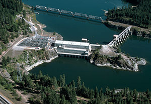
Albeni Falls Dam is located on the Pend Oreille River between Oldtown, Idaho, and Priest River, Idaho. It is located on the site of a natural waterfall named Albeni Falls, named after early pioneer Albeni Poirier. Construction on the dam began in 1951 and was completed in 1955 at a cost of $34 million ($261 million in 2007 dollars).
KUBS
Radio station in Newport, Washington
Distance: Approx. 2954 meters
Latitude and longitude: 48.17833333,-117.08305556
KUBS (91.5 FM) is a high school radio station broadcasting a country music format. Licensed to Newport, Washington, United States, the station is currently owned by Newport Consolidated School District #56415.
Hotel Charbonneau
Historic hotel in Priest River, Idaho, US
Distance: Approx. 9974 meters
Latitude and longitude: 48.179244,-116.908928
The Hotel Charbonneau is located at 88 Wisconsin Street (formally 207 Wisconsin Street) in Priest River, Idaho and is listed on the National Register of Historic Places. It was originally constructed in 1912 by Charles and Dora Charbonneau (architects PJ Young and Charles Charbonneau). During the first half of the 20th century, Priest River and the Hotel Charbonneau, which is located one block away from where the train station used to be, was a popular stopping-off point for people traveling to nearby Spokane, Coeur d'Alene, Sandpoint, and Priest Lake.

Dr. John and Viola Phillips House and Office
Historic house in Washington, United States
Distance: Approx. 246 meters
Latitude and longitude: 48.178233,-117.045901
The Dr. John and Viola Phillips House and Office, at S. 337 Spokane Ave. in Newport, Washington, is a historic house built in 1914.

Penrith, Washington
Unincorporated community in Pend Oreille County, Washington, United States
Distance: Approx. 5164 meters
Latitude and longitude: 48.15222222,-117.09944444
Penrith is an unincorporated community in Pend Oreille County, in the U.S. state of Washington.
Weather in this IP's area
broken clouds
-9 Celsius
-9 Celsius
-9 Celsius
-7 Celsius
1036 hPa
76 %
1036 hPa
931 hPa
10000 meters
0.96 m/s
1.32 m/s
52 degree
62 %

