Country:
 Puerto Rico
Region:
City:
Latitude and Longitude:
Time Zone:
Postal Code:
IP information under different IP Channel
ip-api
Country
Region
City
ASN
Time Zone
ISP
Blacklist
Proxy
Latitude
Longitude
Postal
Route
IPinfo
Country
Region
City
ASN
Time Zone
ISP
Blacklist
Proxy
Latitude
Longitude
Postal
Route
MaxMind
Country
Region
City
ASN
Time Zone
ISP
Blacklist
Proxy
Latitude
Longitude
Postal
Route
Luminati
Country
PRASN
Time Zone
America/Puerto_Rico
ISP
COQUI-NET
Latitude
Longitude
Postal
db-ip
Country
Region
City
ASN
Time Zone
ISP
Blacklist
Proxy
Latitude
Longitude
Postal
Route
ipdata
Country
Region
City
ASN
Time Zone
ISP
Blacklist
Proxy
Latitude
Longitude
Postal
Route
Popular places and events near this IP address
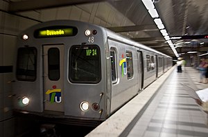
Tren Urbano
Rapid transit system in Puerto Rico
Distance: Approx. 2352 meters
Latitude and longitude: 18.39055,-66.10618
The Tren Urbano (English: Urban Train) is a 10.7-mile (17.2 km) automated rapid transit system that serves the municipalities of San Juan, Guaynabo, and Bayamón, in Puerto Rico. The Tren Urbano consists of 16 stations operating on 10.7 miles (17.2 km) of track along a single line. In 2023, the system had a ridership of 2,738,100, or about 16,200 per weekday as of the second quarter of 2024.

Fort Buchanan (Puerto Rico)
United States Army installation in Puerto Rico
Distance: Approx. 1899 meters
Latitude and longitude: 18.41055556,-66.12055556
United States Army Garrison Fort Buchanan, is a United States Army installation in Puerto Rico. It is located in the metropolitan area of the capital, San Juan.

Hato Rey
Barrio in San Juan, Puerto Rico
Distance: Approx. 2486 meters
Latitude and longitude: 18.4239,-66.0831
Hato Rey is a former barrio located in the northwest part of the dissolved municipality of Río Piedras. It now stretches over three barrios of the municipality of San Juan, Puerto Rico: Hato Rey Norte, Hato Rey Central, and Hato Rey Sur.
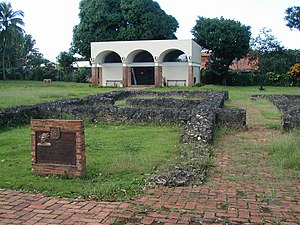
Caparra Archaeological Site
Archaeological site in Guaynabo municipality, Puerto Rico
Distance: Approx. 1414 meters
Latitude and longitude: 18.405,-66.11416667
Caparra is an archaeological site in the municipality of Guaynabo, Puerto Rico. It was declared a U.S. National Historic Landmark in 1994. The site contains the remains of the first Spanish capital of the island, settled in 1508 and officially abandoned in 1521.

Gobernador Piñero, San Juan, Puerto Rico
Administrative area of San Juan, Puerto Rico
Distance: Approx. 1202 meters
Latitude and longitude: 18.409372,-66.091421
Gobernador Piñero is one of the 18 barrios of the municipality of San Juan, Puerto Rico. With a population of 44,006 (2010) living in a land area of 4.44 square miles (11.5 km2), it is San Juan’s second most populated barrio after Santurce, and the fourth largest in land area. This district is named after Jesús T. Piñero who was the first and only native Puerto Rican governor of the territory under the American colonial administration in 1946.

Metropolitan Detention Center, Guaynabo
United States federal prison facility in Guaynabo, Puerto Rico
Distance: Approx. 1691 meters
Latitude and longitude: 18.42333333,-66.1125
The Metropolitan Detention Center, Guaynabo (MDC Guaynabo) is a United States federal prison facility in Guaynabo, Puerto Rico which holds male and female inmates of all security levels who are awaiting trial or sentencing. It is operated by the Federal Bureau of Prisons, a division of the United States Department of Justice. MDC Guaynabo is located next to Fort Buchanan U.S. Army base, and is 6 miles (9.7 km) west of San Juan, the capital of Puerto Rico.

Pueblo Viejo, Guaynabo, Puerto Rico
Barrio of Puerto Rico
Distance: Approx. 1188 meters
Latitude and longitude: 18.413688,-66.113591
Pueblo Viejo is a barrio in the municipality of Guaynabo, Puerto Rico. Its population in 2010 was 23,816.

San Patricio Plaza
Shopping mall located in Guaynabo, Puerto Rico
Distance: Approx. 587 meters
Latitude and longitude: 18.4091,-66.1076
San Patricio Plaza is a 640,000 square feet (59,000 m2) three-level enclosed shopping mall located in Guaynabo, Puerto Rico. The mall is located at the intersection of PR-2, PR-23, and PR-20, and has over 120 stores with its anchors being T.J. Maxx, Capri, Walgreens, PetSmart, Caribbean Cinemas and Office Depot, with two vacant anchor spots last occupied by Kmart and Bed, Bath & Beyond.
Academia San José
Christian school in Guaynabo, Puerto Rico
Distance: Approx. 1327 meters
Latitude and longitude: 18.404383,-66.112758
Academia San José High School was a Christian school, located in Villa Caparra, Puerto Rico. The school was officially shut down in May 2021 after years of financial issues.
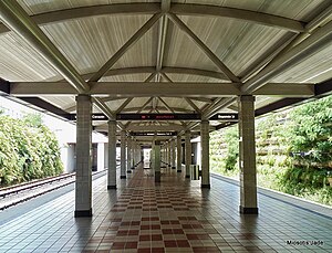
Martínez Nadal station
Rail station of the Tren Urbano system in San Juan, Puerto Rico
Distance: Approx. 2261 meters
Latitude and longitude: 18.39111111,-66.10166667
Martínez Nadal is a rapid transit station in San Juan agglomeration, Puerto Rico. It is located between Torrimar and Las Lomas stations on the sole line of the Tren Urbano system, in the Monacillo Urbano district of the city of San Juan close to the municipal border with Guaynabo. The station is named after the PR-20 highway located nearby, itself named after politician Rafael Martínez Nadal.
Las Lomas station
Rail station of the Tren Urbano system in San Juan, Puerto Rico
Distance: Approx. 2446 meters
Latitude and longitude: 18.39083333,-66.09444444
Las Lomas is a rapid transit station in San Juan agglomeration, Puerto Rico. It is located between Martínez Nadal and San Francisco stations on the sole line of the Tren Urbano system, in the Monacillo Urbano district of the city of San Juan. The station is named after Las Lomas neighborhood which it serves.
San Patricio State Forest
Forest in San Juan, Puerto Rico
Distance: Approx. 1035 meters
Latitude and longitude: 18.40922,-66.09307
San Patricio State Forest (Spanish: Bosque Estatal de San Patricio), also known as the San Patricio Urban Forest (Spanish: Bosque Urbano de San Patricio) is one of the 20 forests that make up the public forest system of Puerto Rico. This is a secondary or second-growth forest is located in the Gobernador Piñero district of San Juan, between the neighborhoods of Villa Borinquen, Caparra Heights and Borinquen Towers complex. The urban forest has entrances on Roosevelt Avenue and Ensenada Street.
Weather in this IP's area
few clouds
28 Celsius
33 Celsius
27 Celsius
29 Celsius
1013 hPa
87 %
1013 hPa
1011 hPa
10000 meters
3.6 m/s
90 degree
20 %
06:12:47
18:24:08