Country:
 France
Region:
City:
Latitude and Longitude:
Time Zone:
Postal Code:
IP information under different IP Channel
ip-api
Country
Region
City
ASN
Time Zone
ISP
Blacklist
Proxy
Latitude
Longitude
Postal
Route
IPinfo
Country
Region
City
ASN
Time Zone
ISP
Blacklist
Proxy
Latitude
Longitude
Postal
Route
MaxMind
Country
Region
City
ASN
Time Zone
ISP
Blacklist
Proxy
Latitude
Longitude
Postal
Route
Luminati
Country
 DE
DEASN
Time Zone
Europe/Berlin
ISP
euNetworks GmbH
Latitude
Longitude
Postal
db-ip
Country
Region
City
ASN
Time Zone
ISP
Blacklist
Proxy
Latitude
Longitude
Postal
Route
ipdata
Country
Region
City
ASN
Time Zone
ISP
Blacklist
Proxy
Latitude
Longitude
Postal
Route
Popular places and events near this IP address

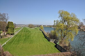
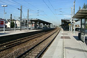
Maisons-Laffitte station
Distance: Approx. 204 meters
Latitude and longitude: 48.946,2.144
Maisons-Laffitte station is a railway station in Maisons-Laffitte, a northwestern suburb of Paris, France. It is on the Paris–Le Havre railway. The rer line A passes through the station.

Sartrouville
Commune in Île-de-France, France
Distance: Approx. 1976 meters
Latitude and longitude: 48.9372,2.1644
Sartrouville (French: [saʁtʁuvil] ) is a commune in the Yvelines department, Île-de-France, north central France. it is located in the north-western suburbs of Paris, 17.1 km (10.6 mi) from the center of Paris.

Maisons-Laffitte
Commune in Île-de-France, France
Distance: Approx. 244 meters
Latitude and longitude: 48.9469,2.1456
Maisons-Laffitte (French pronunciation: [mɛzɔ̃ lafit] ) is a commune in the Yvelines department in the northern Île-de-France region of France. It is a part of the affluent outer suburbs of northwestern Paris, 18.2 km (11.3 mi) from its centre. Maisons-Laffitte is famous for the Château de Maisons-Laffitte, built by architect François Mansart in the 17th century, and its horse racing track, the Maisons-Laffitte Racecourse.
Château de Maisons
French baroque château northwest of Paris
Distance: Approx. 841 meters
Latitude and longitude: 48.94722222,2.15388889
The Château de Maisons (now Château de Maisons-Laffitte [ʃato də mɛzɔ̃ lafit]), designed by François Mansart from 1630 to 1651, is a prime example of French baroque architecture and a reference point in the history of French architecture. The château is located in Maisons-Laffitte, a northwestern suburb of Paris, in the department of Yvelines, Île-de-France.
Maisons-Laffitte Racecourse
Distance: Approx. 2795 meters
Latitude and longitude: 48.96611111,2.16805556
The Hippodrome de Maisons-Laffitte at 1 avenue de la Pelouse in the northwestern Parisian suburb of Maisons-Laffitte in France was a turf horse racing facility and track for Thoroughbred flat racing. Opened in 1878 by Joseph Oller, inventor of the pari-mutuel machine, it sits on 92 hectares that belonged to the wealthy banker Jacques Laffitte. The nearby Château de Maisons-Laffitte is home to The Museum of the Racehorse.

Le Mesnil-le-Roi
Commune in Île-de-France, France
Distance: Approx. 1557 meters
Latitude and longitude: 48.9375,2.1275
Le Mesnil-le-Roi (French pronunciation: [lə menil lə ʁwa] ) is a commune in the Yvelines department in the Île-de-France region in north-central France. It is about 3.5 km (2 mi) from Saint-Germain-en-Laye. The name "Mesnil" comes from Latin: mansionilis meaning "little estate".
Sartrouville station
Distance: Approx. 1503 meters
Latitude and longitude: 48.938,2.157
Sartrouville station is a railway station serving Sartrouville, a northwestern suburb of Paris, France. It is on the Paris–Le Havre railway.
International School of France
Private school in France
Distance: Approx. 1666 meters
Latitude and longitude: 48.95944444,2.15611111
The International School of France, or Ermitage, is an international day and boarding school in Maisons-Laffitte, just outside Paris, France. The school was founded in 1941 by Anne-Marie Thommeret, a woman seeking to improve conditions of students during Nazi occupied France World War II. It offers an English bilingual education up to French Baccalaureate / International Baccalaureate (IB) level. This is a day school with 5- and 7-day boarding houses.
René Dousinelle
Distance: Approx. 718 meters
Latitude and longitude: 48.95,2.13333333
Sous lieutenant René Paul Louis Dousinelle was a French World War I flying ace credited with nine confirmed and three unconfirmed aerial victories.

Achères–Grand-Cormier station
Distance: Approx. 3763 meters
Latitude and longitude: 48.955,2.0922
Achères–Grand-Cormier station is a French railway station in Achères, Yvelines département, Île-de-France region. It is the only station on the RER A that is not accessible to people with disabilities.
Canton of Houilles
Distance: Approx. 3989 meters
Latitude and longitude: 48.93,2.19
The canton of Houilles is an administrative division of the Yvelines department, northern France. Its borders were modified at the French canton reorganisation which came into effect in March 2015. Its seat is in Houilles.
Canton of Sartrouville
Distance: Approx. 1535 meters
Latitude and longitude: 48.94,2.16
The canton of Sartrouville is an administrative division of the Yvelines department, northern France. Its borders were modified at the French canton reorganisation which came into effect in March 2015. Its seat is in Sartrouville.
Weather in this IP's area
clear sky
8 Celsius
8 Celsius
7 Celsius
9 Celsius
1018 hPa
93 %
1018 hPa
1014 hPa
10000 meters
0.45 m/s
2.24 m/s
88 degree
6 %
07:57:06
19:22:09