Country:
 Great Britain
Region:
City:
Latitude and Longitude:
Time Zone:
Postal Code:
IP information under different IP Channel
ip-api
Country
Region
City
ASN
Time Zone
ISP
Blacklist
Proxy
Latitude
Longitude
Postal
Route
IPinfo
Country
Region
City
ASN
Time Zone
ISP
Blacklist
Proxy
Latitude
Longitude
Postal
Route
MaxMind
Country
Region
City
ASN
Time Zone
ISP
Blacklist
Proxy
Latitude
Longitude
Postal
Route
Luminati
Country
GBASN
Time Zone
Europe/London
ISP
CloudCoCo Connect Limited
Latitude
Longitude
Postal
db-ip
Country
Region
City
ASN
Time Zone
ISP
Blacklist
Proxy
Latitude
Longitude
Postal
Route
ipdata
Country
Region
City
ASN
Time Zone
ISP
Blacklist
Proxy
Latitude
Longitude
Postal
Route
Popular places and events near this IP address

Theale
Village and civil parish in England
Distance: Approx. 757 meters
Latitude and longitude: 51.437,-1.077
Theale () is a village and civil parish in West Berkshire, England. It is 5 miles (8 km) southwest of Reading and 10 miles (16 km) east of Thatcham. The compact parish is bounded to the south and south-east by the Kennet & Avon Canal (which here incorporates the River Kennet), to the north by a golf course, to the east by the M4 motorway and to the west by the A340 road.

Calcot, Berkshire
Village in England
Distance: Approx. 1325 meters
Latitude and longitude: 51.441297,-1.049565
Calcot, or Calcot Row, is a village in West Berkshire, England. Calcot is within the built-up area of Reading, located about 3 miles (4.8 km) out of the town centre, and straddles the historic A4 Bath Road. It sits between the hamlet of Horncastle and Junction 12 of the M4 motorway.

Theale railway station
Railway station serving the village of Theale, Berkshire, England
Distance: Approx. 668 meters
Latitude and longitude: 51.433,-1.075
Theale railway station serves the village of Theale, England. It is 41 miles 22 chains (41.28 miles, 66.43 km) measured from London Paddington. The station is served by Great Western Railway local services between Reading and Newbury, limited semi-fast peak services between Bedwyn and London and a limited semi-fast service between London and Westbury, Taunton, Frome, Penzance and Exeter St Davids.
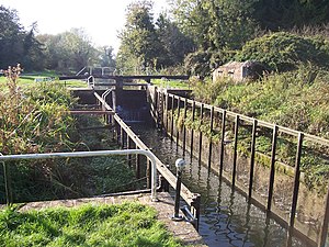
Garston Lock
Distance: Approx. 671 meters
Latitude and longitude: 51.43153,-1.05919
Garston Lock (grid reference SU655707) is a lock on the Kennet and Avon Canal. It is near the M4 motorway and near Reading, England. Garston Lock was built between 1718 and 1723 under the supervision of the engineer John Hore of Newbury, and this stretch of the river is now administered by Canal & River Trust and known as the Kennet Navigation.

Sheffield Lock
Distance: Approx. 548 meters
Latitude and longitude: 51.4309,-1.0687
Sheffield Lock, at grid reference SU648706, is a lock on the Kennet and Avon Canal, in the civil parish of Burghfield in the English county of Berkshire. It is also sometimes known as Shenfield Lock. Sheffield Lock was built between 1718 and 1723 under the supervision of the engineer John Hore of Newbury, and this stretch of the river is now administered by the Canal & River Trust as part of the Kennet Navigation.
Theale Green School
Academy in Theale, Berkshire, England
Distance: Approx. 1386 meters
Latitude and longitude: 51.43654,-1.08625
Theale Green School is a coeducational secondary school and sixth form with academy status, located in the village of Theale, Berkshire, England. The school has 721 pupils on roll, 99 of whom are in the sixth form.

Arlington Business Park
Distance: Approx. 164 meters
Latitude and longitude: 51.436,-1.06861
Arlington Business Park is a business park in Theale (west of Reading, Berkshire), England. specially designed to blend the benefits of a modern working environment with the benefits of outdoor living. The park is home to a number of major corporations such as Nokia, Laithwaites, KPMG, Wrigleys, Wolseley, Arrow ECS, Clearswift and Koch Media.
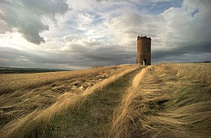
Wilder's Folly
Folly, belvedere, dovecote in UK, United Kingdom
Distance: Approx. 1403 meters
Latitude and longitude: 51.44819,-1.06725
Wilder's Folly (also known as Pincent's Kiln, Nunhide Tower and Flint's Folly) is a folly and dovecote at Nunhide, near the village of Sulham in the English county of Berkshire.

Draper's Osier Bed Stream
Stream in Berkshire, England
Distance: Approx. 490 meters
Latitude and longitude: 51.431779,-1.069837
Draper's Osier Bed Stream is a small stream in southern England, in the county of Berkshire. It is formed at a weir on a section of the River Kennet running alongside the Kennet and Avon Canal, and travels east for a while, before merging with the Kennet upstream of the head of the Holy Brook stream. An osier bed is where historically willows were planted and coppiced to produce withies which were used for basket making, fish-traps, and other purposes.

Pincent's Kiln
Site of Special Scientific Interest near Reading in the English county of Berkshire
Distance: Approx. 713 meters
Latitude and longitude: 51.442,-1.066
Pincent's Kiln is a 0.2-hectare (0.49-acre) geological Site of Special Scientific Interest situated between Theale and Calcot, on the western edge of the built-up area of Reading in the English county of Berkshire. It is a Geological Conservation Review site. The site is a former Quarry which reveals important geological features It is the only remaining permanent exposure of the Tertiary Reading Beds in the area from which they were first described.
RAF Theale
Former Royal Air Force station in Berkshire, England
Distance: Approx. 965 meters
Latitude and longitude: 51.42694444,-1.06555556
Royal Air Force Theale or more simply RAF Theale is a former Royal Air Force satellite station located south of Theale, Berkshire, England. The following units were here at some point: Relief Landing Ground for No. 8 Elementary Flying Training School RAF (September 1939 - July 1941) No.
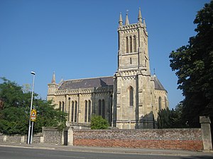
Holy Trinity Church, Theale
Church in England
Distance: Approx. 980 meters
Latitude and longitude: 51.436998,-1.080268
Holy Trinity Church, Theale is a Church of England parish church in the Diocese of Oxford. It was completed in 1832 in the Early English style, influenced by Salisbury Cathedral. The church is a Grade I listed building.
Weather in this IP's area
overcast clouds
13 Celsius
12 Celsius
12 Celsius
14 Celsius
1028 hPa
80 %
1028 hPa
1022 hPa
10000 meters
2.54 m/s
6.59 m/s
11 degree
100 %
06:41:21
19:16:54