Country:
 France
Region:
City:
Latitude and Longitude:
Time Zone:
Postal Code:
IP information under different IP Channel
ip-api
Country
Region
City
ASN
Time Zone
ISP
Blacklist
Proxy
Latitude
Longitude
Postal
Route
IPinfo
Country
Region
City
ASN
Time Zone
ISP
Blacklist
Proxy
Latitude
Longitude
Postal
Route
MaxMind
Country
Region
City
ASN
Time Zone
ISP
Blacklist
Proxy
Latitude
Longitude
Postal
Route
Luminati
Country
FRASN
Time Zone
Europe/Paris
ISP
Groupe convergence.com SAS
Latitude
Longitude
Postal
db-ip
Country
Region
City
ASN
Time Zone
ISP
Blacklist
Proxy
Latitude
Longitude
Postal
Route
ipdata
Country
Region
City
ASN
Time Zone
ISP
Blacklist
Proxy
Latitude
Longitude
Postal
Route
Popular places and events near this IP address

Pagolle
Commune in Nouvelle-Aquitaine, France
Distance: Approx. 5684 meters
Latitude and longitude: 43.2253,-0.9892
Pagolle (French pronunciation: [paɡɔl]; Basque: Pagola) is a commune in the Pyrénées-Atlantiques department in south-western France. It is located in the Northern Basque Country, partly in Lower Navarre and partly in Soule, two former provinces of France.

Aussurucq
Commune in Nouvelle-Aquitaine, France
Distance: Approx. 4107 meters
Latitude and longitude: 43.1503,-0.9325
Aussurucq (French pronunciation: [osyʁyk]; Basque: Altzürükü) is a commune in the Pyrénées-Atlantiques department in the Nouvelle-Aquitaine region of south-western France. The inhabitants are known as Altzürükütar.

Garindein
Commune in Nouvelle-Aquitaine, France
Distance: Approx. 4118 meters
Latitude and longitude: 43.2092,-0.9044
Garindein (French pronunciation: [ɡaʁɛ̃dɛ̃]; Basque: Garindaine) is a commune in the Pyrénées-Atlantiques department in south-western France. It is located in the former province of Soule.

Gotein-Libarrenx
Commune in Nouvelle-Aquitaine, France
Distance: Approx. 3649 meters
Latitude and longitude: 43.1911,-0.8997
Gotein-Libarrenx (French pronunciation: [ɡɔtɛ̃ libaʁɛ̃ks]; Basque: Gotaine-Irabarne) is a commune in the Pyrénées-Atlantiques department in south-western France. It is located in the former province of Soule. The steeple of the church is a trinitarian one.

Idaux-Mendy
Commune in Nouvelle-Aquitaine, France
Distance: Approx. 2462 meters
Latitude and longitude: 43.1819,-0.9144
Idaux-Mendy (Basque: Idauze-Mendi) is a commune in the Pyrénées-Atlantiques department in south-western France. It is located in the former province of Soule.

Menditte
Commune in Nouvelle-Aquitaine, France
Distance: Approx. 4372 meters
Latitude and longitude: 43.1631,-0.9006
Menditte (French pronunciation: [mɛ̃dit]; Basque: Mendikota) is a commune in the Pyrénées-Atlantiques department in south-western France. It is located in the historical province of Soule.

Musculdy
Commune in Nouvelle-Aquitaine, France
Distance: Approx. 2109 meters
Latitude and longitude: 43.1978,-0.9647
Musculdy (French pronunciation: [myskyldi]; Basque: Muskildi) is a commune in the Pyrénées-Atlantiques department in south-western France. It is located in the historical province of Soule.

Ordiarp
Commune in Nouvelle-Aquitaine, France
Distance: Approx. 112 meters
Latitude and longitude: 43.1864,-0.9428
Ordiarp (French pronunciation: [ɔʁdjaʁp]; Basque: Urdiñarbe) is a commune in the Pyrénées-Atlantiques department in south-western France. It is located in the former province of Soule.

Sauguis-Saint-Étienne
Commune in Nouvelle-Aquitaine, France
Distance: Approx. 5965 meters
Latitude and longitude: 43.1528,-0.8867
Sauguis-Saint-Étienne (Basque: Zalgize-Doneztebe) is a commune in the Pyrénées-Atlantiques department in south-western France. It is located in the former province of Soule.
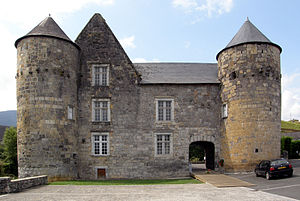
Château de Ruthie
Castle in Aussurucq in the Pyrénées-Atlantiques département of France
Distance: Approx. 4109 meters
Latitude and longitude: 43.15027778,-0.9325
The Château de Ruthie is a castle in the commune of Aussurucq in the Pyrénées-Atlantiques département of France. Construction took place at various times in the 11th, 15th, 17th and 18th centuries. It was listed as a monument historique by the French Ministry of Culture on 30 April 1925, giving protection to its internal decoration.
Canton of Montagne Basque
Distance: Approx. 5785 meters
Latitude and longitude: 43.22,-0.89
The canton of Montagne Basque (Basque Euskal Mendialdea) is an administrative division of the Pyrénées-Atlantiques department, southwestern France. It was created at the French canton reorganisation which came into effect in March 2015. Its seat is in Mauléon-Licharre.

Château de Mauléon
French castle
Distance: Approx. 5952 meters
Latitude and longitude: 43.21916,-0.886388
The Château de Mauléon, known as vieux château ("old castle"), is a castle in the commune of Mauléon-Licharre, in the Pyrénées-Atlantiques département of France. It was registered as a monument historique on 4 May 1925.
Weather in this IP's area
scattered clouds
15 Celsius
15 Celsius
15 Celsius
15 Celsius
1013 hPa
92 %
1013 hPa
991 hPa
10000 meters
2.36 m/s
2.47 m/s
190 degree
44 %
07:49:07
20:05:11