Country:
 Denmark
Region:
City:
Latitude and Longitude:
Time Zone:
Postal Code:
IP information under different IP Channel
ip-api
Country
Region
City
ASN
Time Zone
ISP
Blacklist
Proxy
Latitude
Longitude
Postal
Route
IPinfo
Country
Region
City
ASN
Time Zone
ISP
Blacklist
Proxy
Latitude
Longitude
Postal
Route
MaxMind
Country
Region
City
ASN
Time Zone
ISP
Blacklist
Proxy
Latitude
Longitude
Postal
Route
Luminati
Country
DKRegion
84
City
stenlose
ASN
Time Zone
Europe/Copenhagen
ISP
Telenor A/S
Latitude
Longitude
Postal
db-ip
Country
Region
City
ASN
Time Zone
ISP
Blacklist
Proxy
Latitude
Longitude
Postal
Route
ipdata
Country
Region
City
ASN
Time Zone
ISP
Blacklist
Proxy
Latitude
Longitude
Postal
Route
Popular places and events near this IP address

Birkerød
Town in Capital, Denmark
Distance: Approx. 1547 meters
Latitude and longitude: 55.83333333,12.43333333
Birkerød (Danish: [ˈpiɐ̯kəˌʁøˀð]) is a town in Rudersdal Municipality in the northern outskirts of Copenhagen, Denmark. It is surrounded by several lakes and small woodlands. Birkerød station is located on the Hillerød radial of the S-train suburban network.
Åsebakken Priory
Distance: Approx. 2384 meters
Latitude and longitude: 55.8567,12.4691
Åsebakken Priory, or the Priory of Our Lady of Åsebakken, is a Benedictine monastery of nuns at Birkerød, about 20 km north of Copenhagen in Denmark. The priory is part of the Beuronese Congregation within the Benedictine Confederation.

Birkerød railway station
Railway station in Rudersdal Municipality, Denmark
Distance: Approx. 1033 meters
Latitude and longitude: 55.84027778,12.42388889
Birkerød station is an S-train railway station serving the satellite town of Birkerød north of Copenhagen, Denmark. The station is located in the centre of the town, a short distance from Birkerød Church and Birkerød Lake. Birkerød station is located on the Hillerød radial of Copenhagen's S-train network, a hybrid suburban rail and rapid transit system serving Greater Copenhagen.
Ravnsnæs
Village near Sjælsø, Denmark
Distance: Approx. 2160 meters
Latitude and longitude: 55.86201667,12.45723056
Ravnsnæs is a small village with a population of 580 (1 January 2024), just south of Sjælsø in Denmark. Ravnsnæs is part of the Rudersdal Municipality, and is situated 3.5 km South West of Hørsholm. Watch pictures and fly-over video at landowner's website.

Special Support and Reconnaissance Company
Military unit
Distance: Approx. 3021 meters
Latitude and longitude: 55.8742,12.43
The Special Support and Reconnaissance Company (Danish: Særlig Støtte- og Rekognosceringskompagni), until 1 January 2007 known as the Patrol Company Army Operational Command (Danish: Patruljekompagniet) is the only remaining Long Range Surveillance Company (LRSC) / Long Range Reconnaissance Patrol (LRRP) Coy) in the Danish Armed Forces. The unit is part of the Danish Home Guard, and the only one of its kind, working directly for the Danish Army. It is the only unit in Danish Armed Forces that uses a woven fabric for its cap badge.

Høvelte railway halt
Railway halt in North Zealand, Denmark
Distance: Approx. 2955 meters
Latitude and longitude: 55.85083333,12.38805556
Høvelte railway halt (Danish: Høvelte Trinbræt) is a railway halt on the Hillerød radial of the S-train network in Greater Copenhagen, Denmark. It is located between Birkerød station and Allerød station and primarily serves Høvelte Barracks. There is only one station platform by the northbound track.
Center Sandholm
Danish public institution for asylum seekers
Distance: Approx. 3562 meters
Latitude and longitude: 55.8725,12.4
Center Sandholm, or Sandholm, is a public institution for asylum seekers in Denmark. It is located in Sandholm, Blovstrød, Allerød Kommune. Children and young people under 18 who have fled alone are received at Center Gribskov.

Magleås
Building in Høsterkøb, Denmark
Distance: Approx. 2207 meters
Latitude and longitude: 55.8538,12.4682
Magleås is a mansion in Høsterkøb near Birkerød in northern Zealand, Denmark. It is located in Rudersdal Municipality in the Capital Region of Denmark, 25 km. outside Copenhagen.
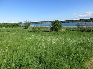
Sjælsø
Distance: Approx. 2089 meters
Latitude and longitude: 55.86527778,12.44388889
Sjælsø is a lake straddling the borders between the municipalities of Rudersdal, Allerød and Hørsholm in North Zealand to the north of Copenhagen, Denmark. Situated immediately to the north of the suburban town of Birkerød, it is surrounded by a mixture of farmland, pastures and small woodlands. The lake has an area of 293 hectares and is relatively shallow.

Sandholm
Danish estate
Distance: Approx. 3195 meters
Latitude and longitude: 55.87,12.40383333
Sandholm is an estate in the parish of Blovstrød, Allerød Municipality some 30 km north of Copenhagen, Denmark.
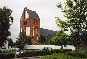
Birkerød Church
Church in Birkerød, Denmark
Distance: Approx. 783 meters
Latitude and longitude: 55.84078,12.4298
Birkerød Church (Danish: Birkerød Kirke) is a church at Birkerød, Rudersdal Municipality, Greater Copenhagen, Denmark. It is one of two churches in the parish of Birkerød, the other being Høsterkøb Church in Høsterkøb which dates to 1908. Birkerød Church is particularly noted for its Gothic frescoes (kalkmalerier).

Høsterkøb Church
Church building in Rudersdal Municipality, Denmark
Distance: Approx. 3419 meters
Latitude and longitude: 55.8514,12.4891
Høsterkøb Church (Danish: Høsterkøb Kirke) is a parish church in the village of Høsterkøb, Rudersdal Municipality, some 20 km north of central Copenhagen, Denmark.
Weather in this IP's area
scattered clouds
8 Celsius
5 Celsius
8 Celsius
9 Celsius
1013 hPa
86 %
1013 hPa
1007 hPa
10000 meters
5.65 m/s
11.24 m/s
240 degree
48 %
07:33:27
18:20:05