Country:
Region:
City:
Latitude and Longitude:
Time Zone:
Postal Code:
IP information under different IP Channel
ip-api
Country
Region
City
ASN
Time Zone
ISP
Blacklist
Proxy
Latitude
Longitude
Postal
Route
Luminati
Country
Region
c
City
kampala
ASN
Time Zone
Africa/Kampala
ISP
Gilat Telecom Ltd.
Latitude
Longitude
Postal
IPinfo
Country
Region
City
ASN
Time Zone
ISP
Blacklist
Proxy
Latitude
Longitude
Postal
Route
db-ip
Country
Region
City
ASN
Time Zone
ISP
Blacklist
Proxy
Latitude
Longitude
Postal
Route
ipdata
Country
Region
City
ASN
Time Zone
ISP
Blacklist
Proxy
Latitude
Longitude
Postal
Route
Popular places and events near this IP address

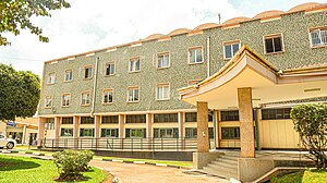
National Library of Uganda
National library of Uganda
Distance: Approx. 418 meters
Latitude and longitude: 0.3228,32.5747
The National Library of Uganda was established by an Act of Parliament in 2003, replacing the Public Libraries Board itself established in 1964. It is the legal deposit library for Uganda and was under the directorship of Gertrude Kayaga Mulindwa.

Watoto Church
Church in Kampala, Uganda
Distance: Approx. 455 meters
Latitude and longitude: 0.3189855,32.5749527
Watoto Church, formerly Kampala Pentecostal Church (KPC) is a Pentecostal church headquartered in Kampala, Uganda. Watoto means "the children" in Swahili.

Uganda National Mosque
Mosque by Muammar Gaddafi located in Kampala Hill, Kampala, Uganda
Distance: Approx. 684 meters
Latitude and longitude: 0.315539,32.568591
The Uganda National Mosque is a mosque located at Kampala Hill in the Old Kampala area of Kampala, Uganda. It is the largest mosque in East Africa in a country where, as of 2014, 13.7% of the population is Muslim. Completed in 2006, it accommodates up to 15,000 worshipers and can hold another 1,100 in the gallery, while the terrace will cater for another 3,500.

Kampala Hill
Place in Central Uganda, Uganda
Distance: Approx. 709 meters
Latitude and longitude: 0.31527778,32.56861111
Kampala Hill, commonly referred to as Old Kampala, is a hill in the centre of Kampala, Uganda's capital and largest city.
Hotel Equatoria
Building in Uganda
Distance: Approx. 410 meters
Latitude and longitude: 0.31805556,32.57361111
Hotel Equatoria was a hotel in Kampala, the capital of Uganda, the third-largest economy in the East African Community. It was a member of the Imperial Hotels Group.
Finance Trust Bank
Commercial bank in Uganda
Distance: Approx. 560 meters
Latitude and longitude: 0.32166667,32.57638889
Finance Trust Bank (FTB), commonly called Finance Trust, is a commercial bank in Uganda. It is licensed by the Bank of Uganda, the central bank and national banking regulator.

Law Development Centre
Legal school in Uganda
Distance: Approx. 493 meters
Latitude and longitude: 0.32444444,32.56861111
The Law Development Centre (LDC) is an educational institution in Uganda for higher learning that offers various legal courses ranging from one month to one year.
Pension Towers
Commercial in Kampala, Uganda
Distance: Approx. 648 meters
Latitude and longitude: 0.32083333,32.57722222
Pension Towers is a building under construction in Kampala, the capital of Uganda and the largest city in that country.
Quality Supermarkets
Ugandan supermarket chain
Distance: Approx. 507 meters
Latitude and longitude: 0.31666667,32.57
Quality Supermarkets is a Ugandan supermarket chain.
Case Medical Centre
Hospital in Central Region, Uganda
Distance: Approx. 555 meters
Latitude and longitude: 0.32444444,32.575
Case Medical Centre, also known as Case Hospital, is an urban, private, upscale, tertiary hospital in Kampala, the capital of Uganda and the largest city in that country. It is one of the few upscale private tertiary care hospitals in the city. The other four hospitals are: International Hospital Kampala, Kampala Hospital, Nakasero Hospital, UMC Victoria Hospital and Paragon Hospital.
Uganda Medical Association
Distance: Approx. 548 meters
Latitude and longitude: 0.31916667,32.57597222
The Uganda Medical Association (UMA), is a registered non-governmental, professional organization that brings together all the qualified and duly registered medical doctors in Uganda.

Fort Lugard
Building in Kampala, Uganda
Distance: Approx. 646 meters
Latitude and longitude: 0.31633738,32.5679461
Fort Lugard is a fort and a museum in Kampala which served as the colonial administrative site of the British Protectorate of Uganda. The fort was occupied by the Buganda Kingdom before President Idi Amin donated the land to the Uganda Muslim Supreme Council.
Weather in this IP's area
scattered clouds
20 Celsius
20 Celsius
20 Celsius
20 Celsius
1013 hPa
79 %
1013 hPa
886 hPa
10000 meters
1.16 m/s
1.79 m/s
358 degree
33 %
06:32:01
18:38:09