Country:
 Tanzania
Region:
City:
Latitude and Longitude:
Time Zone:
Postal Code:
IP information under different IP Channel
ip-api
Country
Region
City
ASN
Time Zone
ISP
Blacklist
Proxy
Latitude
Longitude
Postal
Route
IPinfo
Country
Region
City
ASN
Time Zone
ISP
Blacklist
Proxy
Latitude
Longitude
Postal
Route
MaxMind
Country
Region
City
ASN
Time Zone
ISP
Blacklist
Proxy
Latitude
Longitude
Postal
Route
Luminati
Country
 IL
ILASN
Time Zone
Asia/Jerusalem
ISP
Gilat Telecom Ltd.
Latitude
Longitude
Postal
db-ip
Country
Region
City
ASN
Time Zone
ISP
Blacklist
Proxy
Latitude
Longitude
Postal
Route
ipdata
Country
Region
City
ASN
Time Zone
ISP
Blacklist
Proxy
Latitude
Longitude
Postal
Route
Popular places and events near this IP address

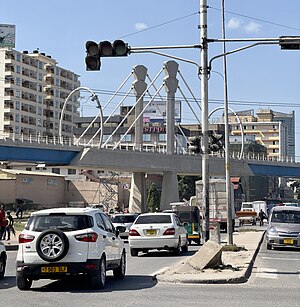
Dar es Salaam
Largest city in Tanzania and capital of Dar es Salaam Region
Distance: Approx. 274 meters
Latitude and longitude: -6.81611111,39.28027778
Dar es Salaam (; from Arabic: دَار السَّلَام, romanized: Dār as-Salām, lit. 'Abode of Peace') is the largest city and financial hub of Tanzania. It is also the capital of the Dar es Salaam Region. With a population of over five million people, Dar es Salaam is the largest city in East Africa and the sixth-largest in Africa.

Mafuta House
Distance: Approx. 652 meters
Latitude and longitude: -6.8151,39.288
Benjamin William Mkapa Pension Tower, formerly known as Mafuta House, is one of the tallest buildings in Dar es Salaam, Tanzania. It is a multi-million U.S. Dollar building owned by the National Social Security Fund (NSSF) that will be used for retail and commercial space. After a 5-year halt due to lack of funds by its previous owners, Tanzania Petroleum Development Corporation (TPDC) and the National Housing Corporation (NHC), its construction resumed in late 2004 when NSSF purchased the unfinished building and continued the construction.
Gerezani
Ward of Ilala District, Dar es Salaam Region
Distance: Approx. 566 meters
Latitude and longitude: -6.8183,39.2875
Gerezani (Kata ya Gerezani, in Swahili) is an administrative ward of the Ilala Municipical Council of the Dar es Salaam Region in Tanzania. The Kariakoo and Mchikichini wards border the ward on its northern side. The ward is bordered by Mchafukoge to the east.

Kisutu
Ward of Ilala District, Dar es Salaam Region
Distance: Approx. 344 meters
Latitude and longitude: -6.8169,39.2856
Kisutu (Kata ya Kisutu, in Swahili) is an administrative ward of the Ilala Municipal Council of the Dar es Salaam Region in Tanzania. Upanga East ward and Kivukoni ward both border the ward to the north and north-east. The ward is bordered to the south by Mchafukoge ward and to the west by Jangwani ward.
CRDB Bank
Commercial bank in Tanzania
Distance: Approx. 625 meters
Latitude and longitude: -6.81486111,39.28763889
CRDB Bank Plc is a commercial bank in Tanzania. It is licensed by the Bank of Tanzania, the central bank and national banking regulator. As of September 2022, CRDB Bank was the largest commercial bank in Tanzania.
Tanzania Public Service College
Public university in Tanzania
Distance: Approx. 307 meters
Latitude and longitude: -6.815,39.28083333
The Tanzania Public Service College (TPSC), an institution of higher learning in Tanzania, mandated to offer courses that prepare school leavers for effective delivery of public service to the citizens of the country. The institution also offers refresher courses to active public servants, to improve and update their knowledge-base and skills.

2013 Dar es Salaam building collapse
Structural failure in Tanzania
Distance: Approx. 268 meters
Latitude and longitude: -6.81832778,39.28464722
The Dar es Salaam building collapse occurred during the early hours of Good Friday on 29 March 2013 when a 16-floor residential apartment building collapsed on a nearby mosque compound, killing 36 people and trapping over 60 under the rubble.
Dar es Salaam School of Journalism
Distance: Approx. 205 meters
Latitude and longitude: -6.817628,39.284308
Dar es Salaam School of Journalism (DSJ) is a Tanzanian educational institution specializing in journalism. Established in 1998, it is the second private institution to provide journalism education in the country. The institution offers a wide range of programs, including certificates and diplomas in journalism, digital marketing, public relations, and information technology.

College of Business Education
Public university in Dar es Salaam, Tanzania
Distance: Approx. 350 meters
Latitude and longitude: -6.81433333,39.28122222
The College of Business Education (CBE) is a higher learning institution in Tanzania established in 1965, registered and accredited by the National Council for Technical Education (NACTE) to offer Certificate, Diploma and Degree Programmes in various fields of study.

Uhuru Monument
Monument in Dar es Salaam, Tanzania
Distance: Approx. 349 meters
Latitude and longitude: -6.8182,39.2795
The Uhuru Monument (also known as Uhuru Torch Monument) is a landmark monument and tourist attraction located in Mchafukoge ward of Ilala District in Dar es Salaam Region, Tanzania. It is a white obelisk with a replica of the Uhuru Torch mounted at its top. It is located at the Mnazi Mmoja Park in the city centre and is partly fenced.
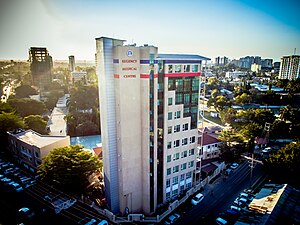
Regency Medical Centre
Hospital in Dar es Salaam, Tanzania
Distance: Approx. 593 meters
Latitude and longitude: -6.81297222,39.27925
Regency Medical Centre is a multi-specialty hospital located on Aly Khan Road, in Dar es Salaam, Tanzania. Established in 1999, the hospital was founded by Dr. Rajni Kanabar, who was also the hospital's Chairman and the convener of the Tanzania Babies Heart Project till 25 June 2019.
International Commercial Bank Tanzania
Commercial bank in Tanzania
Distance: Approx. 658 meters
Latitude and longitude: -6.81361111,39.27777778
International Commercial Bank Tanzania Limited (ICBT), is a commercial bank in Tanzania, the third-largest economy in the East African Community. It is licensed by the Bank of Tanzania, the country's central bank and national banking regulator.
Weather in this IP's area
clear sky
24 Celsius
25 Celsius
24 Celsius
24 Celsius
1017 hPa
83 %
1017 hPa
1015 hPa
10000 meters
3.42 m/s
6.25 m/s
128 degree
4 %
06:15:04
18:19:43