62.49.135.35 - IP Lookup: Free IP Address Lookup, Postal Code Lookup, IP Location Lookup, IP ASN, Public IP
Country:
Region:
City:
Location:
Time Zone:
Postal Code:
IP information under different IP Channel
ip-api
Country
Region
City
ASN
Time Zone
ISP
Blacklist
Proxy
Latitude
Longitude
Postal
Route
Luminati
Country
Region
eng
City
ealing
ASN
Time Zone
Europe/London
ISP
Vodafone Limited
Latitude
Longitude
Postal
IPinfo
Country
Region
City
ASN
Time Zone
ISP
Blacklist
Proxy
Latitude
Longitude
Postal
Route
IP2Location
62.49.135.35Country
Region
england
City
southport
Time Zone
Europe/London
ISP
Language
User-Agent
Latitude
Longitude
Postal
db-ip
Country
Region
City
ASN
Time Zone
ISP
Blacklist
Proxy
Latitude
Longitude
Postal
Route
ipdata
Country
Region
City
ASN
Time Zone
ISP
Blacklist
Proxy
Latitude
Longitude
Postal
Route
Popular places and events near this IP address

Southport
Town in Merseyside, England
Distance: Approx. 87 meters
Latitude and longitude: 53.6475,-3.00527778
Southport is a seaside town in the Metropolitan Borough of Sefton in Merseyside, England. It lies on the West Lancashire coastal plain and the east coast of the Irish Sea, approximately 17 miles (27 km) north of Liverpool and 15 miles (24 km) southwest of Preston. At the 2021 census, Southport had a population of 94,421, making it the eleventh most populous settlement in North West England and the third most populous settlement in the Liverpool City Region.

Southport (UK Parliament constituency)
Parliamentary constituency in the United Kingdom, 1885 onwards
Distance: Approx. 95 meters
Latitude and longitude: 53.647,-3.007
Southport is a constituency in Merseyside which has been represented in the House of Commons of the UK Parliament since 2024 by Patrick Hurley of the Labour Party.

Southport railway station
Railway station in Merseyside, England
Distance: Approx. 310 meters
Latitude and longitude: 53.647,-3.002
Southport railway station serves the town of Southport, Merseyside, England. The station is the terminal of the electricified Southport branch of the Northern Line of the electric Merseyrail network and the diesel-operated Manchester-Southport Line. It is the fourth busiest station on the Merseyrail network.
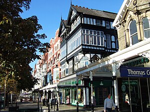
Lord Street, Southport
High street of Southport, Lancashire, England
Distance: Approx. 40 meters
Latitude and longitude: 53.648,-3.006
Lord Street is the main shopping street of Southport, in Merseyside. It is 1 mile (1.6 km) long, with a roundabout marking each end of the street. There are many water features, gardens and architectural buildings along the entire street, with a mix of residential, commercial and public buildings.
Wayfarers Arcade
Shopping mall in Merseyside, England
Distance: Approx. 79 meters
Latitude and longitude: 53.6485,-3.0067
Wayfarers Arcade (previously the Leyland Arcade and Burton Arcade) is a Grade II listed structure located in the seaside town of Southport, Merseyside on the famous boulevard of Lord Street in the town centre. The arcade is a near untouched building with the glass dome and Victorian shop fronts below it, creating a shopping arcade.

Monumental Obelisk, Southport
Memorial to 1886 lifeboat disaster
Distance: Approx. 221 meters
Latitude and longitude: 53.6485,-3.00964
The Monumental Obelisk, Southport, stands on the Promenade in Southport. Merseyside, England. It commemorates a number of events, mainly relating to the work of the Southport lifeboats, and in particular the loss of fourteen lifeboatmen when their boat capsized in 1886.

Southport War Memorial
Distance: Approx. 171 meters
Latitude and longitude: 53.6487,-3.0044
Southport War Memorial is in London Square, Lord Street, Southport, Merseyside, England. It consists of an obelisk flanked by two colonnades in the form of Greek temples. Outside the colonnades are memorial gardens, each containing a Pool of Remembrance and fountains.
Southport Model Railway Village
Tourist attraction in Lancashire, England
Distance: Approx. 282 meters
Latitude and longitude: 53.6487,-3.0105
Southport Model Railway Village is a tourist attraction located in Southport, England. It is a model village with a focus on trains and railways.

Southport Arts Centre
Historic site in Merseyside, England
Distance: Approx. 74 meters
Latitude and longitude: 53.6472,-3.006
Southport Arts Centre, formerly known as Cambridge Hall, is on the east side of Lord Street, Southport, Sefton, Merseyside, England, and stands between Southport Town Hall and the Atkinson Art Gallery and Library. It was built in 1873–74 and originally contained an assembly hall. The centre contains mixed architectural styles and has a tall clock tower at the right end.

Southport Town Hall
Municipal building in Southport, Merseyside, England
Distance: Approx. 68 meters
Latitude and longitude: 53.6475,-3.0056
Southport Town Hall is on the east side of Lord Street, Southport, Sefton, Merseyside, England. It was built in 1852–53 in Palladian style, and extended to the rear on three occasions later in the century. The town hall has a symmetrical stuccoed façade with a central staircase leading up to a porch flanked by columns.

Atkinson Art Gallery and Library
Historic site in Merseyside, England
Distance: Approx. 89 meters
Latitude and longitude: 53.647,-3.0065
The Atkinson is a building on the east side of Lord Street extending round the corner into Eastbank Street, Southport, Sefton, Merseyside, England. The building is a combination of two former buildings, the original Atkinson Art Gallery and Library that opened in 1878, and the adjacent Manchester and Liverpool District Bank that was built in 1879. These were combined in 1923–24 and the interiors have been integrated.

Dune Radio
Radio station
Distance: Approx. 56 meters
Latitude and longitude: 53.6483,-3.0064
Dune Radio (formerly Sandgrounder Radio) is an Independent Local Radio station for Liverpool, The Wirral, Southport, Blackpool and the North West Coast of England. The station broadcasts on DAB Digital Radio and Online (website/App/Smart Speakers) as well as on Freeview Channel 277 across the Granada region. The station started life as a 28-day RSL (Restricted Service Licence) covering Southport on FM in November 2015.
Weather in this IP's area
mist
9 Celsius
6 Celsius
7 Celsius
11 Celsius
1021 hPa
100 %
1021 hPa
1019 hPa
2500 meters
6.17 m/s
270 degree
75 %

