Country:
Region:
City:
Latitude and Longitude:
Time Zone:
Postal Code:
IP information under different IP Channel
ip-api
Country
Region
City
ASN
Time Zone
ISP
Blacklist
Proxy
Latitude
Longitude
Postal
Route
Luminati
Country
Region
11
City
lisbon
ASN
Time Zone
Europe/Lisbon
ISP
Servicos De Comunicacoes E Multimedia S.A.
Latitude
Longitude
Postal
IPinfo
Country
Region
City
ASN
Time Zone
ISP
Blacklist
Proxy
Latitude
Longitude
Postal
Route
db-ip
Country
Region
City
ASN
Time Zone
ISP
Blacklist
Proxy
Latitude
Longitude
Postal
Route
ipdata
Country
Region
City
ASN
Time Zone
ISP
Blacklist
Proxy
Latitude
Longitude
Postal
Route
Popular places and events near this IP address

Church of São Francisco (Porto)
Church in Porto, Portugal
Distance: Approx. 73 meters
Latitude and longitude: 41.141016,-8.61574
The Church of Saint Francis (Portuguese: Igreja de São Francisco) is the most prominent Gothic monument in Porto, Portugal, being also noted for its outstanding Baroque inner decoration.

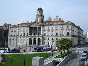
Palácio da Bolsa
Historical building in Porto, Portugal
Distance: Approx. 111 meters
Latitude and longitude: 41.141367,-8.615428
The Stock Exchange Palace (Portuguese: Palácio da Bolsa) is a historical building in Porto, Portugal. The palace was built in the 19th century by the city's Commercial Association (Portuguese: Associação Comercial do Porto) in Neoclassical style.
Casa do Infante
Residence in São Nicolau e Vitória, Portugal
Distance: Approx. 176 meters
Latitude and longitude: 41.14080556,-8.6145
The Casa do Infante (House of the Prince), or alternately as the Alfândega Velha (Old Customshouse), is a historical house in the civil parish of Cedofeita, Santo Ildefonso, Sé, Miragaia, São Nicolau e Vitória, in the municipality of Porto, in northern Portugal. The house was originally built in the 14th century as customs and mint, although its present condition derives mostly from a remodelling carried out in the 17th century. Its name derived from an oral tradition that suggested the house was the birthplace of Prince Henry the Navigator in 1394.

Ribeira Square
Historical square in Porto, Portugal
Distance: Approx. 303 meters
Latitude and longitude: 41.1407,-8.613
The Ribeira Square (Portuguese: Praça da Ribeira) is a historical square in Porto, Portugal.
Factory House
Factory House in Sé, Portugal
Distance: Approx. 256 meters
Latitude and longitude: 41.14138889,-8.61361111
The British Factory House (Portuguese: Feitoria Inglesa), also known as the British Association House, is an 18th-century Neo-Palladian building located in the northern Portuguese centre of Porto, associated with the influence of Britain in the port wine industry. This building is part of a group of buildings and infrastructure that mark the British presence in the city of Porto, which include the Oporto Cricket and Lawn Tennis Club (founded 1855) and the Oporto British School (1894).

English Club of Porto
Residence in São Nicolau e Vitória, Portugal
Distance: Approx. 297 meters
Latitude and longitude: 41.14333333,-8.61805556
The English Club of Porto (Portuguese: Edifício na Rua das Virtudes/Clube dos Ingleses), is the name referring to the building along Rua das Virtudes, a 14th-century manorhouse situated in the Portugueses civil parish of Cedofeita, Santo Ildefonso, Sé, Miragaia, São Nicolau e Vitória, municipality of Porto.

Palace of São João Novo
Palace in São Nicolau e Vitória, Portugal
Distance: Approx. 204 meters
Latitude and longitude: 41.1425,-8.61777778
The Palace of São João Novo (Portuguese: Palácio de São João Novo) is a palace/residence in the civil parish of Cedofeita, Santo Ildefonso, Sé, Miragaia, São Nicolau e Vitória, in the municipality of Porto, in the Portuguese district of the same name.
Palacete de Belomonte
Palacette in São Nicolau e Vitória, Portugal
Distance: Approx. 183 meters
Latitude and longitude: 41.1425,-8.61611111
The Palacette of Belomonte (Portuguese: Palacete de Belomonte/Palácio de Belomonte/Casa dos Pacheco Pereira) is a former-residence on Rua de Belomonte, in the civil parish of Cedofeita, Santo Ildefonso, Sé, Miragaia, São Nicolau e Vitória, in the northern Portuguese city of Porto.
Fountain of Rua das Taipas
Fountain in Porto, Portugal
Distance: Approx. 259 meters
Latitude and longitude: 41.14305556,-8.61777778
The Fountain of Rua das Taipas (Portuguese: Chafariz da Rua das Taipas) is a fountain in the civil parish of Cedofeita, Santo Ildefonso, Sé, Miragaia, São Nicolau e Vitória, in the municipality of Porto, Portugal.
Igreja dos Grilos
Church in Porto, Portugal
Distance: Approx. 361 meters
Latitude and longitude: 41.1419,-8.6125
Igreja dos Grilos is a church and convent in Porto, Portugal.
Igreja de São Bento da Vitória
Distance: Approx. 369 meters
Latitude and longitude: 41.14416667,-8.61583333
Igreja de São Bento da Vitória is a church in Portugal. It is classified as a National Monument.

2017 Red Bull Air Race of Porto
Distance: Approx. 197 meters
Latitude and longitude: 41.13916667,-8.61611111
The 2017 Red Bull Air Race of Porto was the fifth round of the 2017 Red Bull Air Race World Championship season, the twelfth season of the Red Bull Air Race World Championship. The event was held on Douro River in Porto, Portugal.
Weather in this IP's area
clear sky
14 Celsius
14 Celsius
14 Celsius
16 Celsius
1018 hPa
88 %
1018 hPa
1014 hPa
10000 meters
07:26:21
17:13:22


