Country:
 Germany
Region:
City:
Latitude and Longitude:
Time Zone:
Postal Code:
IP information under different IP Channel
ip-api
Country
Region
City
ASN
Time Zone
ISP
Blacklist
Proxy
Latitude
Longitude
Postal
Route
IPinfo
Country
Region
City
ASN
Time Zone
ISP
Blacklist
Proxy
Latitude
Longitude
Postal
Route
MaxMind
Country
Region
City
ASN
Time Zone
ISP
Blacklist
Proxy
Latitude
Longitude
Postal
Route
Luminati
Country
DERegion
bw
City
esslingenamneckar
ASN
Time Zone
Europe/Berlin
ISP
euNetworks GmbH
Latitude
Longitude
Postal
db-ip
Country
Region
City
ASN
Time Zone
ISP
Blacklist
Proxy
Latitude
Longitude
Postal
Route
ipdata
Country
Region
City
ASN
Time Zone
ISP
Blacklist
Proxy
Latitude
Longitude
Postal
Route
Popular places and events near this IP address

Frankfurt Airport
Major international airport serving Frankfurt am Main, Hesse, Germany
Distance: Approx. 4319 meters
Latitude and longitude: 50.03333333,8.57055556
Frankfurt Airport (German: Flughafen Frankfurt Main [ˈfluːkhaːfn̩ ˈfʁaŋkfʊʁt ˈmaɪn]) (IATA: FRA, ICAO: EDDF), is Germany's main international airport by passenger numbers, located in Frankfurt, Germany's fifth-largest city. In the German Aeronautical Information Publication, its name is Frankfurt Main Airport. The airport is operated by Fraport and serves as the main hub for Lufthansa, including Lufthansa CityLine and Lufthansa Cargo as well as Condor and AeroLogic.

Rhein-Main Air Base
United States Air Force Base in Germany (Permanently Closed)
Distance: Approx. 4010 meters
Latitude and longitude: 50.03019444,8.58804722
Rhein-Main Air Base was a United States Air Force air base near the city of Frankfurt am Main, Germany. It was a Military Airlift Command (MAC) and United States Air Forces in Europe (USAFE) installation, occupying the south side of Frankfurt Airport. Its military airport codes (IATA: FRF, ICAO: EDAF) are discontinued.

Mörfelden-Walldorf
Town in Hesse, Germany
Distance: Approx. 710 meters
Latitude and longitude: 50,8.58333333
Mörfelden-Walldorf is a town in the Groß-Gerau district, situated in the Frankfurt Rhine-Main region in the federal state (Bundesland) Hesse, Germany.
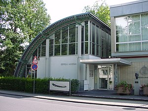
Zeppelin Museum Zeppelinheim
Distance: Approx. 5186 meters
Latitude and longitude: 50.0349,8.6145
Zeppelin Museum Zeppelinheim is located in Neu-Isenburg near Frankfurt am Main. The design of the museum building, constructed in 1988, resembles a quarter section of the hull of the LZ 10. The transport airships Graf Zeppelin and Hindenburg, as well as the second Graf Zeppelin (LZ 130), were based near the present site of the museum, on a site later occupied by the Rhein-Main Air Base.

Schloß Wolfsgarten
Distance: Approx. 4701 meters
Latitude and longitude: 49.98027778,8.63927778
Schloss Wolfsgarten is a former hunting seat of the ruling family of Hesse-Darmstadt, located in the German state of Hessen, approximately 15 kilometers south of Frankfurt am Main. The hunting lodge was established between 1722 and 1724 by Landgrave Ernst Ludwig of Hesse-Darmstadt. Ernst Ludwig's purpose in establishing Wolfsgarten was to pursue his passion for hunting with dogs which he introduced into Hesse in 1709.
Oberwaldberg
Mountain in Germany
Distance: Approx. 1236 meters
Latitude and longitude: 49.98861111,8.59194444
Oberwaldberg is a mountain of Hesse, Germany.

Gundbach
River in Germany
Distance: Approx. 5477 meters
Latitude and longitude: 49.9771,8.5062
Gundbach is a river of Hesse, Germany. At its confluence with the Geräthsbach west of Mörfelden-Walldorf, the Schwarzbach is formed.

Zeppelinheim station
Railway station in Neu-Isenburg, Germany
Distance: Approx. 5101 meters
Latitude and longitude: 50.036958,8.60554
Zeppelinheim station is a station in the district of Zeppelinheim of the town of Neu-Isenburg in the German state of Hesse. It is located in the urban periphery of Frankfurt am Main and adjacent to Frankfurt Airport. The station is at the junction with a connecting curve from the Mannheim–Frankfurt railway to Frankfurt Airport long-distance station.
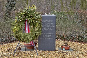
KZ Walldorf
Distance: Approx. 2702 meters
Latitude and longitude: 50.01877778,8.58347222
KZ Walldorf was a subcamp of the Natzweiler-Struthof concentration camp and existed from 22 August to 24 November 1944 near the village of Walldorf in Hesse. Erected after the deportations of the Jews in Hungary as part of the Nazi extermination through labour plan, about 1,700 female inmates were assigned to work on the first paved runway of the nearby Rhein-Main Airport.

Langen (Hess) station
Railway station in Langen, Hesse, Germany
Distance: Approx. 5677 meters
Latitude and longitude: 49.99345,8.656905
Langen (Hess) station is in the town of Langen in the German state of Hesse. It was opened in 1846 with the Main-Neckar Railway and is now served by the Rhine-Main S-Bahn. The station has two side platforms, an island platform and a through track without a platform.

Dorian Gray (club)
Distance: Approx. 6271 meters
Latitude and longitude: 50.051094,8.57416613
Dorian Gray was a nightclub in the 1980s and 1990s, located in Frankfurt Airport in Frankfurt am Main, Germany. Founders Gerd Schüler and Michael Presinger opened the club on November 8, 1978, intending to offer events similar to those at Studio 54 in New York City. Dorian Gray was one of the largest nightclubs in Germany at that time.

Rhein-Main Air Base bombing
Distance: Approx. 3918 meters
Latitude and longitude: 50.0298,8.5834
The Rhein-Main Air Base bombing was a terrorist car bomb attack against the American Rhein-Main Air Base near Frankfurt am Main in West Germany on 8 August 1985. Two Americans were killed and more than 20 people were injured. The blast was powerful and caused debris and damage to the base including to 30 vehicles, trees and windows.
Weather in this IP's area
mist
15 Celsius
14 Celsius
14 Celsius
16 Celsius
1014 hPa
90 %
1014 hPa
1002 hPa
10000 meters
1.03 m/s
100 %
07:52:36
18:28:38