Country:
 USA
USARegion:
City:
Latitude and Longitude:
Time Zone:
Postal Code:
IP information under different IP Channel
ip-api
Country
Region
City
ASN
Time Zone
ISP
Blacklist
Proxy
Latitude
Longitude
Postal
Route
IPinfo
Country
Region
City
ASN
Time Zone
ISP
Blacklist
Proxy
Latitude
Longitude
Postal
Route
MaxMind
Country
Region
City
ASN
Time Zone
ISP
Blacklist
Proxy
Latitude
Longitude
Postal
Route
Luminati
Country
 DE
DERegion
he
City
frankfurtammain
ASN
Time Zone
Europe/Berlin
ISP
euNetworks GmbH
Latitude
Longitude
Postal
db-ip
Country
Region
City
ASN
Time Zone
ISP
Blacklist
Proxy
Latitude
Longitude
Postal
Route
ipdata
Country
Region
City
ASN
Time Zone
ISP
Blacklist
Proxy
Latitude
Longitude
Postal
Route
Popular places and events near this IP address
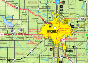
Oaklawn-Sunview, Kansas
Unincorporated community in Sedgwick County, Kansas
Distance: Approx. 1632 meters
Latitude and longitude: 37.61027778,-97.29694444
Oaklawn-Sunview is a census-designated place (CDP) in Sedgwick County, Kansas, United States. As of the 2020 census, the population was 2,880. It is located on the south side of Wichita along the west side of K-15 (Southeast Blvd) and 47th Street South intersection.

McConnell Air Force Base
US Air Force base near Wichita, Kansas, United States
Distance: Approx. 3661 meters
Latitude and longitude: 37.62305556,-97.26722222
McConnell Air Force Base (IATA: IAB, ICAO: KIAB, FAA LID: IAB) is a United States Air Force base located four miles (6 km) southeast of the central business district of Wichita, a city in Sedgwick County, Kansas, United States. The airbase was named in honor of the brothers Fred and Thomas McConnell of Wichita, who had both been Air Force pilots and veterans of World War II. It is the home of Air Mobility Command's 22nd Air Refueling Wing (22 ARW), Air Force Reserve Command's 931st Air Refueling Wing (931 ARW), and the Kansas Air National Guard's 184th Wing (184 W). McConnell's primary mission is to provide global reach by conducting air refueling and airlift where and when needed.
Herman Hill riot
Riot in Wichita, Kansas, United States
Distance: Approx. 4023 meters
Latitude and longitude: 37.64888889,-97.33861111
The 1979 Easter Sunday Herman Hill riot in Wichita, Kansas, United States – a confrontation between 500 law-enforcement personnel (from Wichita and surrounding jurisdictions) and the 3,500 attendees at a rock concert in Herman Hill Park – was one of the largest riots in the history of Wichita, drawing national attention and creating political and legal controversy. The event resulted in over 50 injuries, to more than two dozen police officers and dozens of civilians, and over 80 arrests. Tear gas was used and firearms were discharged.

Joyland Amusement Park (Wichita, Kansas)
Defunct American amusement park
Distance: Approx. 2225 meters
Latitude and longitude: 37.641223,-97.30388
Joyland Amusement Park was an amusement park in Wichita, Kansas, United States. It was in continuous operation from 1949 to 2004, standing vacant for two years before closing permanently in 2006. It was once the largest theme park in central Kansas and featured a wooden roller coaster as well as 15 other rides.
Wichita South High School
High school in Wichita, Kansas
Distance: Approx. 3424 meters
Latitude and longitude: 37.631748,-97.345361
Wichita South High School, known locally as South, is a public secondary school in Wichita, Kansas. It is operated by Wichita USD 259 school district and serves students in grades 9 to 12. It is also known as Wichita High School South.

Kansas Aviation Museum
Aviation Museum in Wichita, Kansas USA
Distance: Approx. 3312 meters
Latitude and longitude: 37.63222222,-97.27361111
The Kansas Aviation Museum is a museum located in Wichita, Kansas, United States, near 31st South and George Washington Blvd. The building, designed by Glen H. Thomas, was the former Wichita Municipal Airport terminal from 1935 to 1954. In February of 2024, the Wichita City Council approved an honorary over-naming of George Washington Blvd.

Riverside Township, Sedgwick County, Kansas
Township in Kansas, United States
Distance: Approx. 2330 meters
Latitude and longitude: 37.60138889,-97.31555556
Riverside Township is a township in Sedgwick County, Kansas, United States. As of the 2000 United States Census, it had a population of 15,694.
Chisholm Creek (Kansas)
Stream in Sedgwick County, Kansas, U.S.
Distance: Approx. 1175 meters
Latitude and longitude: 37.631682,-97.304767
Chisholm Creek is a stream in Sedgwick County, Kansas, in the United States. Chisholm Creek was named for Jesse Chisholm, a pioneer who settled on the creek in the 1860s.
South Central, Wichita, Kansas
Neighborhood in Sedgwick, Kansas, United States
Distance: Approx. 4913 meters
Latitude and longitude: 37.66027778,-97.33555556
South Central is a neighborhood in Wichita, Kansas, United States. A mixed commercial and residential area on the east bank of the Arkansas River, it is among the city’s oldest neighborhoods.
Linwood, Wichita, Kansas
Neighborhood in Sedgwick, Kansas, United States
Distance: Approx. 5281 meters
Latitude and longitude: 37.66805556,-97.32083333
Linwood is a residential neighborhood in Wichita, Kansas, United States. It lies in the south-central part of the city west of Interstate 135.
Southwest, Wichita, Kansas
Neighborhood in Sedgwick, Kansas, United States
Distance: Approx. 4619 meters
Latitude and longitude: 37.63777778,-97.35694444
Southwest is a mixed commercial and residential neighborhood in Wichita, Kansas, United States. It consists of a large area west of the Arkansas River in the southern part of the city.
South City, Wichita, Kansas
Neighborhood in Sedgwick, Kansas, United States
Distance: Approx. 2120 meters
Latitude and longitude: 37.6375,-97.32194444
South City is a neighborhood in Wichita, Kansas, United States. A mixed commercial, industrial, and residential area, it lies on the east bank of the Arkansas River in the south-central part of the city.
Weather in this IP's area
clear sky
14 Celsius
13 Celsius
12 Celsius
15 Celsius
1021 hPa
69 %
1021 hPa
975 hPa
10000 meters
4.12 m/s
110 degree
07:05:53
19:47:56