Country:
 Switzerland
Region:
City:
Latitude and Longitude:
Time Zone:
Postal Code:
IP information under different IP Channel
ip-api
Country
Region
City
ASN
Time Zone
ISP
Blacklist
Proxy
Latitude
Longitude
Postal
Route
IPinfo
Country
Region
City
ASN
Time Zone
ISP
Blacklist
Proxy
Latitude
Longitude
Postal
Route
MaxMind
Country
Region
City
ASN
Time Zone
ISP
Blacklist
Proxy
Latitude
Longitude
Postal
Route
Luminati
Country
CHRegion
zh
City
forchsudlteil
ASN
Time Zone
Europe/Zurich
ISP
Genossenschaft GGA Maur
Latitude
Longitude
Postal
db-ip
Country
Region
City
ASN
Time Zone
ISP
Blacklist
Proxy
Latitude
Longitude
Postal
Route
ipdata
Country
Region
City
ASN
Time Zone
ISP
Blacklist
Proxy
Latitude
Longitude
Postal
Route
Popular places and events near this IP address

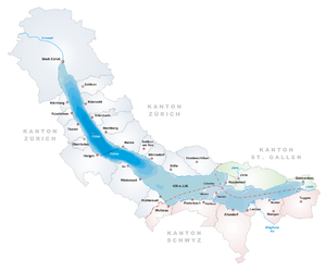
Greifensee (lake)
Lake in Switzerland
Distance: Approx. 3946 meters
Latitude and longitude: 47.35,8.68333333
Greifensee is a lake in the canton of Zürich in Switzerland.

Zumikon
Municipality in Zurich, Switzerland
Distance: Approx. 2072 meters
Latitude and longitude: 47.33333333,8.61666667
Zumikon is a municipality in the district of Meilen in the canton of Zürich in Switzerland. It is located in the Pfannenstiel region.
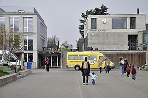
Inter-Community School Zurich
School in Zumikon, Switzerland
Distance: Approx. 1932 meters
Latitude and longitude: 47.338,8.6223
The Inter-Community School Zurich (ICS or ICSZ) is a private, independent, international, co-educational day school and offers a comprehensive educational programme in English for children from ages of 3 to 18. The school is international in character and welcomes students of all nationalities. Since 1971, the Inter-Community School has been located in Zumikon near Zurich, Switzerland.

Aabach (Greifensee)
River in Switzerland
Distance: Approx. 4379 meters
Latitude and longitude: 47.3516,8.6888
The Aabach (also Aa, or Ustermer Aa for disambiguation with the Mönchaltorfer Aa) is a minor river in the canton of Zürich, Switzerland. At a length of 11.2 kilometres (7.0 mi), it flows from Pfäffikersee to the Greifensee. Its valley is known as Aatal ("Aa Valley"), eponymous of the settlement Aathal.
Uster District
District in Switzerland
Distance: Approx. 3946 meters
Latitude and longitude: 47.35,8.68333333
Uster District is one of the twelve districts of the canton of Zürich, Switzerland. Its capital is the city of Uster. The German-speaking district has a population of 135,234 (as of 31 December 2020).
Maur, Switzerland
Municipality in Zurich, Switzerland
Distance: Approx. 3076 meters
Latitude and longitude: 47.35,8.66666667
Maur is a municipality in the district of Uster in the canton of Zürich in Switzerland.

Wulp Castle
Distance: Approx. 2867 meters
Latitude and longitude: 47.32158333,8.60586111
The ruins of Wulp Castle (‹See Tfd›German: Ruine Wulp or Burg Wulp) is a castle located besides Küsnachter Tobel in the municipality of Küsnacht and the canton of Zurich in Switzerland. It was built during the high Middle Ages. Despite this, the castle is documented only in a few found texts, and much of the castle's history is not known.

Forch
Distance: Approx. 846 meters
Latitude and longitude: 47.325,8.65333333
Forch is a village and a mountain pass (el. 682 m (2,238 ft)) located in the municipalities of Küsnacht and Maur in the canton of Zürich, Switzerland.
Goldcoast (Switzerland)
Eastern shore of Lake Zürich
Distance: Approx. 4340 meters
Latitude and longitude: 47.29805556,8.60527778
The Swiss Goldcoast (‹See Tfd›German: Goldküste) is the name given to the lower eastern shore of the Lake Zürich. This prosperous region lies on the north-eastern shore of the lake and thus benefits from the evening sun. The Goldcoast is noted for its low tax rate and high property prices.

Küsnachter Tobel
River in Switzerland
Distance: Approx. 4035 meters
Latitude and longitude: 47.31846111,8.59105
Küsnachter Tobel (lit. 'Küsnacht Gorge') is a small river canyon or gorge, respectively, on the southwestern slope of the Pfannenstiel mountain in the canton of Zürich, Switzerland, formed by the Küsnachter Dorfbach (lit. 'Küsnacht village creek'), which drains into Lake Zurich.
Öschbrig
Mountain in Switzerland
Distance: Approx. 4057 meters
Latitude and longitude: 47.35833333,8.61388889
Öschbrig (also known as Oetlisberg) with an elevation of 696 metres (2,283 ft), is a wooded mountain in Switzerland overlooking to the east Zürichsee (Lake Zürich).

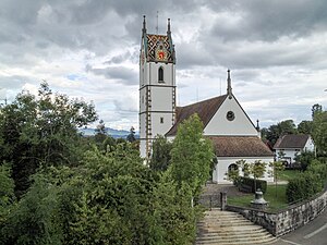
Forch railway station
Railway station in Switzerland
Distance: Approx. 464 meters
Latitude and longitude: 47.32532,8.64794
Forch is a railway station in the Swiss canton of Zürich and the municipality of Küsnacht. It is the principal intermediate station and headquarters of the Forchbahn (FB), which is operated as Zürich S-Bahn service S18 and provides links to the city of Zürich and the nearby village of Esslingen. The station is operated by the Forchbahn, and serves the village of Forch.
Weather in this IP's area
light rain
9 Celsius
9 Celsius
8 Celsius
10 Celsius
1010 hPa
88 %
1010 hPa
926 hPa
10000 meters
1.54 m/s
75 %
07:32:45
18:53:19