Country:
 Czech Republic
Region:
City:
Latitude and Longitude:
Time Zone:
Postal Code:
IP information under different IP Channel
ip-api
Country
Region
City
ASN
Time Zone
ISP
Blacklist
Proxy
Latitude
Longitude
Postal
Route
IPinfo
Country
Region
City
ASN
Time Zone
ISP
Blacklist
Proxy
Latitude
Longitude
Postal
Route
MaxMind
Country
Region
City
ASN
Time Zone
ISP
Blacklist
Proxy
Latitude
Longitude
Postal
Route
Luminati
Country
CZRegion
10
City
prague
ASN
Time Zone
Europe/Prague
ISP
Vodafone Czech Republic a.s.
Latitude
Longitude
Postal
db-ip
Country
Region
City
ASN
Time Zone
ISP
Blacklist
Proxy
Latitude
Longitude
Postal
Route
ipdata
Country
Region
City
ASN
Time Zone
ISP
Blacklist
Proxy
Latitude
Longitude
Postal
Route
Popular places and events near this IP address
Third Czechoslovak Republic
Republic in Central Europe from 1945 to 1948
Distance: Approx. 439 meters
Latitude and longitude: 50.0833,14.4667
The Third Czechoslovak Republic (Czech: Třetí Československá republika; Slovak: Tretia česko-slovenská republika), officially the Czechoslovak Republic (Czech: Československá republika; Slovak: Československá republika), was a sovereign state from April 1945 to February 1948 following the end of World War II. After the fall of Nazi Germany, the country was reformed and reassigned coterminous borders as its pre-war predecessor state, First Czechoslovak Republic; it likewise restored the predecessor's international recognition. Due to the rise of the Communist Party of Czechoslovakia (KSČ), Czechoslovakia fell within the Soviet sphere of influence, and this circumstance dominated any plans or strategies for post-war reconstruction. Consequently, the political and economic organisation of Czechoslovakia became largely a matter of negotiations between Edvard Beneš and the Communist Party members exiled in Moscow.
Czech and Slovak Federative Republic
Republic in Central Europe between 1990 and 1992
Distance: Approx. 435 meters
Latitude and longitude: 50.08333333,14.46666667
After the Velvet Revolution in late-1989, Czechoslovakia adopted the official short-lived country name Czech and Slovak Federative Republic (Czech: Česká a Slovenská Federativní Republika, Slovak: Česká a Slovenská Federatívna Republika; ČSFR) during the period from 23 April 1990 until 31 December 1992, after which the country was peacefully dissolved into the Czech Republic and the Slovak Republic.

Czech Socialist Republic
Part of Czechoslovakia between 1969 and 1990
Distance: Approx. 439 meters
Latitude and longitude: 50.0833,14.4667
The Czech Socialist Republic (Czech: Česká socialistická republika, ČSR) was a republic within the Czechoslovak Socialist Republic. The name was used from 1 January 1969 to November 1989, when the previously unitary Czechoslovak state changed into a federation. From 1990 to 1992, the Czech Republic (Czech: Česká republika, ČR) existed as a federal subject within the Czech and Slovak Federative Republic, and later became the independent Czech Republic.

Prague 3
Place in Czech Republic
Distance: Approx. 525 meters
Latitude and longitude: 50.08444444,14.45416667
Prague 3 (formally the Prague 3 Municipal District, Czech: Městská čast Praha 3), is a second-tier municipality in Prague. It is geographically identical to the national administrative district (správní obvod) and city administrative district (městský obvod) of the same name. The district includes most of the cadastral area of Žižkov and parts of Vinohrady, Vysočany and Strašnice.

Church of Saint Roch, Žižkov
Distance: Approx. 322 meters
Latitude and longitude: 50.0825,14.46027778
The Church of Saint Roch, located on Olšany Square (Czech: Olšanské náměstí), is the oldest church in present-day Žižkov, a cadastral district of Prague, Czech Republic. The Baroque structure was built between 1680 and 1682 by Jan Hainric, probably according to plans by the renowned French architect Jean Baptiste Mathey.

Unicorn University
Distance: Approx. 209 meters
Latitude and longitude: 50.08683333,14.46309722
Unicorn University, formerly known as Unicorn College, is a vocationally oriented private university located in Prague. It was established in 2007 by Unicorn a.s. The institution was transferred under the ownership of Unicorn Learning Centre a.s.

Czech College
College in Prague, Czech Republic
Distance: Approx. 471 meters
Latitude and longitude: 50.08570833,14.45484167
Czech College is a further education institute located in Žižkov, Prague, Czech Republic, approved by the Ministry of Education, Youth and Sports. The college is partnered with the University of Northampton to deliver selected programs in Prague. The college runs undergraduate and postgraduate programs from four separate schools, and has approximately 130+ students, of which 90% are international.

Parukářka Park
Mountain and park in Prague, Czech Republic
Distance: Approx. 63 meters
Latitude and longitude: 50.08475278,14.46162778
Parukářka Park is a park in Žižkov, Prague, Czech Republic.

Statue of Jaroslav Hašek
Sculpture in Prague, Czech Republic
Distance: Approx. 640 meters
Latitude and longitude: 50.08652222,14.45263889
The statue of Jaroslav Hašek (Czech: Socha Jaroslava Haška) is an outdoor monument and equestrian statue by Karel Nepraš and Karolína Neprašová, installed at Prokopovo náměstí in the Žižkov district of Prague, Czech Republic. The sculpture was installed in 2005, having been completed by Nepraš's daughter Karolína after his death. It is located in an area where Hašek lived during writing of his famous novel The Good Soldier Švejk.

Statue of Karel Havlíček Borovský, Prague
Statue in Prague, Czech Republic
Distance: Approx. 510 meters
Latitude and longitude: 50.08510833,14.45426111
The statue of Karel Havlíček Borovský (Czech: Socha Karla Havlíčka Borovského) is an outdoor sculpture in Žižkov, Prague, Czech Republic.

CETIN building
Distance: Approx. 572 meters
Latitude and longitude: 50.08357778,14.46894167
The CETIN building was a building complex in Žižkov, Prague 3 district near Olšany Cemetery. Built in 1979 as the Central Telecommunications Building (Czech: Ústřední telekomunikační budova), it became the headquarters of major operators such as SPT Telecom and O2 Czech Republic after the Velvet Revolution and formation of the Czech Republic. In 2017, the complex was bought by Czech developer Central Group, and until 2022, it served as headquarters of the CETIN telecommunications company.
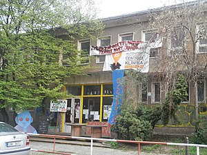
Klinika
Evicted self-managed project in Prague, Czech Republic
Distance: Approx. 450 meters
Latitude and longitude: 50.0877775,14.4663731
Klinika was a squatted self-managed social centre in Žižkov, Prague, from 2014 until 2019. It followed in the tradition of anarchist projects such as Ladronka and Milada.
Weather in this IP's area
clear sky
13 Celsius
13 Celsius
12 Celsius
15 Celsius
1024 hPa
86 %
1024 hPa
993 hPa
10000 meters
2.57 m/s
360 degree
06:44:22
19:07:28