Country:
 Czech Republic
Region:
City:
Latitude and Longitude:
Time Zone:
Postal Code:
IP information under different IP Channel
ip-api
Country
Region
City
ASN
Time Zone
ISP
Blacklist
Proxy
Latitude
Longitude
Postal
Route
IPinfo
Country
Region
City
ASN
Time Zone
ISP
Blacklist
Proxy
Latitude
Longitude
Postal
Route
MaxMind
Country
Region
City
ASN
Time Zone
ISP
Blacklist
Proxy
Latitude
Longitude
Postal
Route
Luminati
Country
CZRegion
64
City
brno
ASN
Time Zone
Europe/Prague
ISP
Vodafone Czech Republic a.s.
Latitude
Longitude
Postal
db-ip
Country
Region
City
ASN
Time Zone
ISP
Blacklist
Proxy
Latitude
Longitude
Postal
Route
ipdata
Country
Region
City
ASN
Time Zone
ISP
Blacklist
Proxy
Latitude
Longitude
Postal
Route
Popular places and events near this IP address

South Moravian Region
Region of the Czech Republic
Distance: Approx. 770 meters
Latitude and longitude: 49.16666667,16.58333333
The South Moravian Region (Czech: Jihomoravský kraj; German: Südmährische Region, pronounced [zyːtˈmɛːʁɪʃə ʁeˈɡi̯oːn]; Slovak: Juhomoravský kraj), or just South Moravia, is an administrative unit (kraj) of the Czech Republic, located in the south-western part of its historical region of Moravia (an exception is Jobova Lhota which traditionally belongs to Bohemia). The region's capital is Brno, the nation's 2nd largest city. South Moravia is bordered by the South Bohemian Region to the west, Vysočina Region to the north-west, Pardubice Region to the north, Olomouc Region to the north-east, Zlín Region to the east, Trenčín and Trnava Regions, Slovakia to the south-east and Lower Austria, Austria to the south.
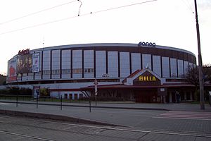
Winning Group Arena
Ice hockey stadium in the Czech Republic
Distance: Approx. 3194 meters
Latitude and longitude: 49.18542,16.602053
Winning Group Arena, is an indoor arena in Brno, Czech Republic. The capacity of the arena is 7,700 people and it was built in 1982. It is currently home to the HC Kometa Brno ice hockey team.
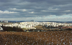
Brno-Bohunice
Place in South Moravia, Czech Republic
Distance: Approx. 777 meters
Latitude and longitude: 49.16944444,16.57916667
Brno-Bohunice is a municipal district of the city of Brno, the second largest city in the Czech Republic. It is located in the southwest part of the city. It is first mentioned in 1237.

Brno Exhibition Centre
Distance: Approx. 2709 meters
Latitude and longitude: 49.1875,16.57805556
Brno Exhibition Center (Czech: Brněnské výstaviště) is a convention centre based in Brno, Czech Republic. It was established in 1928. The centre occupies a site on 667,000 square metres (7,180,000 sq ft) and provides a total net exhibition area of 125,496 square metres (1,350,830 sq ft) including open-air space and exhibition halls with an exhibition area of 61,479 square metres (661,750 sq ft).

Moravany (Brno-Country District)
Municipality in South Moravian, Czech Republic
Distance: Approx. 1981 meters
Latitude and longitude: 49.14555556,16.57611111
Moravany (German: Morbes) is a municipality and village in Brno-Country District in the South Moravian Region of the Czech Republic. It has about 3,500 inhabitants.

Nebovidy (Brno-Country District)
Municipality in South Moravian, Czech Republic
Distance: Approx. 2947 meters
Latitude and longitude: 49.14138889,16.55138889
Nebovidy is a municipality and village in Brno-Country District in the South Moravian Region of the Czech Republic. It has about 900 inhabitants. Nebovidy lies approximately 9 kilometres (6 mi) south-west of Brno and 186 km (116 mi) south-east of Prague.
Ostopovice
Municipality in South Moravian, Czech Republic
Distance: Approx. 2092 meters
Latitude and longitude: 49.16111111,16.54555556
Ostopovice is a municipality and village in Brno-Country District in the South Moravian Region of the Czech Republic. It has about 1,700 inhabitants. Ostopovice lies approximately 7 kilometres (4 mi) south-west of Brno and 185 km (115 mi) south-east of Prague.
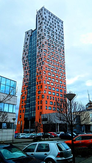
AZ Tower
Distance: Approx. 2681 meters
Latitude and longitude: 49.17583333,16.60555556
The AZ Tower is a high rise building in the city of Brno, Czech Republic. The tower is 111 m (364 ft) tall, and it has 30 floors. It is currently the tallest building in the Czech Republic.

Spielberk Towers
Distance: Approx. 3141 meters
Latitude and longitude: 49.18222222,16.60611111
Spielberk Towers are two high-rises in Brno, Czech Republic. The towers are part of the complex Spielberk Office Centre. The towers are named as Tower A and Tower B. The lower tower is named Tower A and the taller tower is named Tower B. The Tower A is 53 metres high and the taller Tower B is 85 metres high.
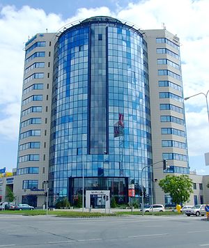
M-Palace
Office in Brno, Czech Republic
Distance: Approx. 2704 meters
Latitude and longitude: 49.17720556,16.60456444
M-Palace (Czech: M-Palác) is a high-rise building in Brno, Czech Republic. The building is 60 meters high and it is one of the tallest buildings in Brno. The building consists of a sixteen-floors tower and two-floors building.

2016 UEC European Track Championships (under-23 & junior)
Cycling championship held in Montichiari, Italy
Distance: Approx. 2409 meters
Latitude and longitude: 49.1847,16.579
The 2016 UEC European Track Championships (under-23 & junior) were the 16th continental championships for European under-23 and junior track cyclists, and the 7th since the event was renamed following the reorganisation of European track cycling in 2010. The event took place at the Velodromo Fassa Bortolo in Montichiari, Italy from 12 to 17 July 2016.

Brno-Nový Lískovec
Self-governing District of Brno in South Moravian Region, Czech Republic
Distance: Approx. 1933 meters
Latitude and longitude: 49.17777778,16.55944444
Brno-Nový Lískovec is one of the 29 self-governing districts of Brno, Czech Republic, located in the southwestern part of the city. It consists of the urban district of Nový Lískovec (German: Neu Leskau, lit. 'New Lískovec')), originally a settlement of the municipality of Lískovec, with which it was annexed to Brno in 1919.
Weather in this IP's area
clear sky
14 Celsius
14 Celsius
12 Celsius
16 Celsius
1022 hPa
62 %
1022 hPa
996 hPa
10000 meters
2.68 m/s
40 degree
06:36:13
18:58:43