Country:
Region:
City:
Latitude and Longitude:
Time Zone:
Postal Code:
IP information under different IP Channel
ip-api
Country
Region
City
ASN
Time Zone
ISP
Blacklist
Proxy
Latitude
Longitude
Postal
Route
IPinfo
Country
Region
City
ASN
Time Zone
ISP
Blacklist
Proxy
Latitude
Longitude
Postal
Route
MaxMind
Country
Region
City
ASN
Time Zone
ISP
Blacklist
Proxy
Latitude
Longitude
Postal
Route
Luminati
Country
Region
eng
City
bishopsstortford
ASN
Time Zone
Europe/London
ISP
TalkTalk
Latitude
Longitude
Postal
db-ip
Country
Region
City
ASN
Time Zone
ISP
Blacklist
Proxy
Latitude
Longitude
Postal
Route
ipdata
Country
Region
City
ASN
Time Zone
ISP
Blacklist
Proxy
Latitude
Longitude
Postal
Route
Popular places and events near this IP address

Macclesfield (UK Parliament constituency)
Parliamentary constituency in the United Kingdom, 1885 onwards
Distance: Approx. 660 meters
Latitude and longitude: 53.31666667,-2.13333333
Macclesfield is a constituency in Cheshire represented in the House of Commons of the UK Parliament since 2024 by Tim Roca, a member of the Labour Party.

Woodford, Greater Manchester
Village in Stockport, Greater Manchester, England
Distance: Approx. 2310 meters
Latitude and longitude: 53.339,-2.156
Woodford is a village in the Metropolitan Borough of Stockport, Greater Manchester, England. It lies in the historic county of Cheshire, 5.2 miles (8.4 km) south of Stockport, 5.7 miles (9.2 km) north-west of Macclesfield and 10.7 miles (17.2 km) south-east of Manchester. Woodford was a hamlet in the parish of Prestbury throughout the Middle Ages.

Adlington, Cheshire
Human settlement in England
Distance: Approx. 568 meters
Latitude and longitude: 53.319,-2.133
Adlington is a village and civil parish in the unitary authority of Cheshire East and the ceremonial county of Cheshire, England. It is known as Eduluintune in the Domesday Book. According to the 2001 census the civil parish had a population of 1,081 people across 401 households.

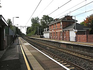
Adlington railway station (Cheshire)
Railway station in Cheshire, England
Distance: Approx. 486 meters
Latitude and longitude: 53.32,-2.134
Adlington (Cheshire) railway station serves the village of Adlington in Cheshire, England. It was staffed for many years but is now unstaffed. The station building is privately owned.

Macclesfield Rural District
Distance: Approx. 1555 meters
Latitude and longitude: 53.33333333,-2.13333333
Macclesfield Rural District was a rural district of Cheshire, England from 1894 to 1974. Macclesfield as a Municipal Borough and Bollington as an urban district formed an enclave which was surrounded by Macclesfield RD. The district was formed in 1894 based on Macclesfield rural sanitary district by the Local Government Act 1894. It was abolished under the Local Government Act 1972 in 1974 and became part of the new Macclesfield borough, which was itself abolished in 2009.

Woodford Aerodrome
Former airport and aircraft factory in the United Kingdom
Distance: Approx. 2051 meters
Latitude and longitude: 53.33805556,-2.14888889
Woodford Aerodrome (ICAO: EGCD) is a former airfield and aircraft factory at Woodford, Greater Manchester, England, 6 NM (11 km; 6.9 mi) north of Macclesfield. It was opened by the Avro company after the First World War and became an important production centre for military aircraft in the Second World War. Notable planes made at the factory include the Avro Anson, Avro Lancaster, Avro Shackleton and Avro Vulcan.

Adlington Hall
Country house in Cheshire, England
Distance: Approx. 233 meters
Latitude and longitude: 53.3209,-2.1446
Adlington Hall is a country house near Adlington, Cheshire. The oldest part of the existing building, the Great Hall, was constructed between 1480 and 1505; the east wing was added in 1581. The Legh family has lived in the hall and in previous buildings on the same site since the early 14th century.

Mottram Hall
Historic site in Cheshire, England
Distance: Approx. 2344 meters
Latitude and longitude: 53.3115,-2.1734
Mottram Hall (also known as Mottram New Hall or the Mottram Hall Hotel) is a former country house to the northeast of the village of Mottram St. Andrew, Cheshire, England. It is recorded in the National Heritage List for England as a designated Grade II* listed building.
Bonis Hall
Distance: Approx. 1460 meters
Latitude and longitude: 53.30752,-2.14689
Bonis Hall is a former country house to the north of Prestbury, Cheshire, England. It was the seat of the Pigot family until 1746, when it was bought by Charles Legh of Adlington. In the early part of the 19th century it was remodelled and used by the Legh family as a dower house.
Mill House, Adlington
Country house in Cheshire, England
Distance: Approx. 1370 meters
Latitude and longitude: 53.3079,-2.14073
Mill House is a former country house in the parish of Adlington, Cheshire, England. It is dated 1603, and was built by Sir Uriah Legh, of the Legh family of Adlington, as a dower house. Alterations were made to it in the middle of the 18th century and in the early 20th century.
Willot Hall
Country house in Cheshire, England
Distance: Approx. 1862 meters
Latitude and longitude: 53.31933,-2.16926
Willot Hall is a country house in the parish of Prestbury, some 4.5 km to the east of Wilmslow, Cheshire, England. It originated as a medieval hall house in the later part of the 15th century. This was encased in stone in the 17th century.

Avro Heritage Museum
Aviation museum in Greater Manchester, England
Distance: Approx. 1804 meters
Latitude and longitude: 53.33502,-2.15228
Avro Heritage Museum is an aviation museum in Woodford, Greater Manchester, England, that opened on 13 November 2015. It is located at the former Woodford Aerodrome, and it replaced the former Avro Heritage Centre.
Weather in this IP's area
few clouds
14 Celsius
14 Celsius
14 Celsius
15 Celsius
1009 hPa
79 %
1009 hPa
996 hPa
10000 meters
4.92 m/s
8.94 m/s
159 degree
20 %
07:41:11
18:05:47