62.182.107.93 - IP Lookup: Free IP Address Lookup, Postal Code Lookup, IP Location Lookup, IP ASN, Public IP
Country:
Region:
City:
Location:
Time Zone:
Postal Code:
IP information under different IP Channel
ip-api
Country
Region
City
ASN
Time Zone
ISP
Blacklist
Proxy
Latitude
Longitude
Postal
Route
Luminati
Country
Region
24
City
myszkow
ASN
Time Zone
Europe/Warsaw
ISP
P. P. H. U. 'HI-TECH' Michal Bialas
Latitude
Longitude
Postal
IPinfo
Country
Region
City
ASN
Time Zone
ISP
Blacklist
Proxy
Latitude
Longitude
Postal
Route
IP2Location
62.182.107.93Country
Region
slaskie
City
myszkow
Time Zone
Europe/Warsaw
ISP
Language
User-Agent
Latitude
Longitude
Postal
db-ip
Country
Region
City
ASN
Time Zone
ISP
Blacklist
Proxy
Latitude
Longitude
Postal
Route
ipdata
Country
Region
City
ASN
Time Zone
ISP
Blacklist
Proxy
Latitude
Longitude
Postal
Route
Popular places and events near this IP address

Myszków
Place in Silesian Voivodeship, Poland
Distance: Approx. 885 meters
Latitude and longitude: 50.57055556,19.31444444
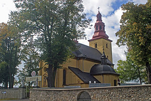
Myszków [ˈmɨʂkuf] is a town in Poland, with 31,650 inhabitants (2019). Situated on the Warta river in the Silesian Voivodeship (since 1999), previously in Częstochowa Voivodeship (1975–1998), it is the capital of Myszków County. Myszków historically belongs to Lesser Poland, and the area where the town is located was, until the Partitions of Poland, part of Kraków Voivodeship's County of Lelów.

Myszków County
County in Silesian Voivodeship, Poland
Distance: Approx. 1065 meters
Latitude and longitude: 50.58333333,19.31666667
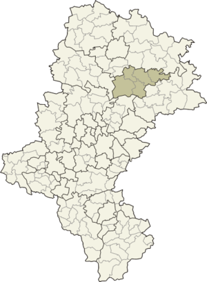
Myszków County (Polish: powiat myszkowski) is a unit of territorial administration and local government (powiat) in Silesian Voivodeship, southern Poland. It came into being on January 1, 1999, as a result of the Polish local government reforms passed in 1998. Its administrative seat and largest town is Myszków, which lies 44 kilometres (27 mi) north-east of the regional capital Katowice.
Gmina Żarki
Gmina in Silesian Voivodeship, Poland
Distance: Approx. 6711 meters
Latitude and longitude: 50.62805556,19.37027778
Gmina Żarki is an urban-rural gmina (administrative district) in Myszków County, Silesian Voivodeship, in southern Poland. Its seat is the town of Żarki, which lies approximately 7 kilometres (4 mi) north-east of Myszków and 50 km (31 mi) north-east of the regional capital Katowice. The gmina covers an area of 100.67 square kilometres (38.9 sq mi), and as of 2019 its total population is 8,446.
Koclin
Village in Silesian Voivodeship, Poland
Distance: Approx. 5948 meters
Latitude and longitude: 50.56277778,19.24277778
Koclin [ˈkɔt͡slin] is a village in the administrative district of Gmina Koziegłowy, within Myszków County, Silesian Voivodeship, in southern Poland. It lies approximately 7 kilometres (4 mi) south-east of Koziegłowy, 6 km (4 mi) south-west of Myszków, and 39 km (24 mi) north-east of the regional capital Katowice.
Lgota Górna
Village in Silesian Voivodeship, Poland
Distance: Approx. 6457 meters
Latitude and longitude: 50.60027778,19.24222222
Lgota Górna [ˈlɡɔta ˈɡurna] is a village in the administrative district of Gmina Koziegłowy, within Myszków County, Silesian Voivodeship, in southern Poland. It lies approximately 6 kilometres (4 mi) east of Koziegłowy, 6 km (4 mi) west of Myszków, and 43 km (27 mi) north-east of the regional capital Katowice.
Lgota-Nadwarcie
Village in Silesian Voivodeship, Poland
Distance: Approx. 6264 meters
Latitude and longitude: 50.60666667,19.25111111
Lgota-Nadwarcie [ˈlɡɔta nadˈvart͡ɕɛ] is a village in the administrative district of Gmina Koziegłowy, within Myszków County, Silesian Voivodeship, in southern Poland. It lies approximately 7 kilometres (4 mi) east of Koziegłowy, 6 km (4 mi) north-west of Myszków, and 44 km (27 mi) north-east of the regional capital Katowice.

Pińczyce
Village in Silesian Voivodeship, Poland
Distance: Approx. 5975 meters
Latitude and longitude: 50.55,19.25
Pińczyce [piɲˈt͡ʂɨt͡sɛ] is a village in the administrative district of Gmina Koziegłowy, within Myszków County, Silesian Voivodeship, in southern Poland. It lies approximately 9 kilometres (6 mi) south-east of Koziegłowy, 6 km (4 mi) south-west of Myszków, and 38 km (24 mi) north-east of the regional capital Katowice.
Postęp, Silesian Voivodeship
Village in Silesian Voivodeship, Poland
Distance: Approx. 4938 meters
Latitude and longitude: 50.6,19.26666667
Postęp [ˈpɔstɛmp] is a village in the administrative district of Gmina Koziegłowy, within Myszków County, Silesian Voivodeship, in southern Poland. It lies approximately 8 kilometres (5 mi) east of Koziegłowy, 4 km (2 mi) north-west of Myszków, and 44 km (27 mi) north-east of the regional capital Katowice.
Pustkowie Lgockie
Village in Silesian Voivodeship, Poland
Distance: Approx. 5530 meters
Latitude and longitude: 50.55361111,19.25416667
Pustkowie Lgockie [pustˈkɔvjɛ ˈlɡɔt͡skʲɛ] is a village in the administrative district of Gmina Koziegłowy, within Myszków County, Silesian Voivodeship, in southern Poland. It lies approximately 9 kilometres (6 mi) south-east of Koziegłowy, 6 km (4 mi) south-west of Myszków, and 39 km (24 mi) north-east of the regional capital Katowice.
Stara Huta, Silesian Voivodeship
Village in Silesian Voivodeship, Poland
Distance: Approx. 5928 meters
Latitude and longitude: 50.54305556,19.25777778
Stara Huta [ˈstara ˈxuta] is a village in the administrative district of Gmina Koziegłowy, within Myszków County, Silesian Voivodeship, in southern Poland. It lies approximately 10 kilometres (6 mi) south-east of Koziegłowy, 7 km (4 mi) south-west of Myszków, and 38 km (24 mi) north-east of the regional capital Katowice.
Żarki-Letnisko
Village in Silesian Voivodeship, Poland
Distance: Approx. 6170 meters
Latitude and longitude: 50.61666667,19.26666667
Żarki-Letnisko [ˈʐarki lɛtˈniskɔ] is a village in the administrative district of Gmina Poraj, within Myszków County, Silesian Voivodeship, in southern Poland. It lies approximately 6 kilometres (4 mi) north-west of Myszków and 45 km (28 mi) north-east of the regional capital Katowice.
Wysoka Lelowska
Village in Silesian Voivodeship, Poland
Distance: Approx. 6501 meters
Latitude and longitude: 50.63333333,19.33333333
Wysoka Lelowska [vɨˈsɔka lɛˈlɔfska] is a village in the administrative district of Gmina Żarki, within Myszków County, Silesian Voivodeship, in southern Poland. It lies approximately 3 kilometres (2 mi) west of Żarki, 6 km (4 mi) north of Myszków, and 49 km (30 mi) north-east of the regional capital Katowice.
Weather in this IP's area
scattered clouds
-3 Celsius
-6 Celsius
-7 Celsius
-3 Celsius
1039 hPa
74 %
1039 hPa
1002 hPa
10000 meters
2.26 m/s
3.76 m/s
115 degree
34 %