Country:
 Greece
Region:
City:
Latitude and Longitude:
Time Zone:
Postal Code:
IP information under different IP Channel
ip-api
Country
Region
City
ASN
Time Zone
ISP
Blacklist
Proxy
Latitude
Longitude
Postal
Route
IPinfo
Country
Region
City
ASN
Time Zone
ISP
Blacklist
Proxy
Latitude
Longitude
Postal
Route
MaxMind
Country
Region
City
ASN
Time Zone
ISP
Blacklist
Proxy
Latitude
Longitude
Postal
Route
Luminati
Country
GRRegion
i
City
athens
ASN
Time Zone
Europe/Athens
ISP
Nova Telecommunications & Media Single Member S.A
Latitude
Longitude
Postal
db-ip
Country
Region
City
ASN
Time Zone
ISP
Blacklist
Proxy
Latitude
Longitude
Postal
Route
ipdata
Country
Region
City
ASN
Time Zone
ISP
Blacklist
Proxy
Latitude
Longitude
Postal
Route
Popular places and events near this IP address
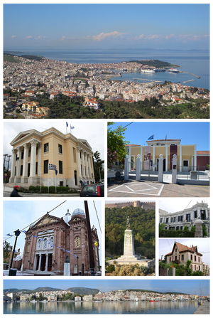
Mytilene
Capital of the Greek island of Lesbos
Distance: Approx. 4606 meters
Latitude and longitude: 39.1,26.55
Mytilene (; Greek: Μυτιλήνη, romanized: Mytilíni [mitiˈlini] ) is the capital of the Greek island of Lesbos, and its port. It is also the capital and administrative center of the North Aegean Region, and hosts the headquarters of the University of the Aegean. It was founded in the 11th century BC. Mytilene is one of the two municipalities on the island of Lesbos, created in 2019; the other is West Lesbos.
Battle of Mytilene (1690)
Battle of the Great Turkish War
Distance: Approx. 4606 meters
Latitude and longitude: 39.1,26.55
The Battle of Mytilene was a naval battle that occurred on 8 September 1690 at Mytilene between a Venetian fleet under Daniele Dolfin and a combined Muslim fleet made up of Ottoman and Barbary ships. The battle resulted in a victory for the Venetian naval forces. This defeat inspired Suleiman II to end Ottoman reliance on Barbary pirates.

Panagiouda
Community in Greece
Distance: Approx. 1918 meters
Latitude and longitude: 39.147,26.529
Panagiouda (Greek: Παναγιούδα, Panagioúda) is a village on the east coast of Lesbos; 6 km (3.7 miles) north of Mytilene. As of 2011, Panagiouda had 906 inhabitants which were primarily fishermen.
University of the Aegean
Public university in Greece
Distance: Approx. 4606 meters
Latitude and longitude: 39.1,26.55
The University of the Aegean (UA) (Greek: Πανεπιστήμιο Αιγαίου) is a public, multi-campus university located in Lesvos, Chios, Samos, Rhodes, Syros and Lemnos, Greece. It was founded on March 20, 1984, by the Presidential Act 83/1984 and its administrative headquarters are located in the town of Mytilene, on the island of Lesvos. The university today comprises five Schools and 18 Departments offering undergraduate and post-graduate degrees programmes.

Charshi Hamam, Mytilene
Hamam in Mytilene, Greece
Distance: Approx. 4250 meters
Latitude and longitude: 39.11041667,26.55713889
The Çarşı Hamam (Greek: Τσαρσί Χαμάμ, in Turkish meaning "market bath") is an Ottoman bath (hamam) in the town of Mytilene in Lesbos, Greece. It was probably built in the first quarter of the 19th century, and formed part of the nearby Yeni ("New") Mosque complex. As its name indicates, it was the main market bath for the local neighbourhood.

Saint Therapon (Mytilene)
Distance: Approx. 4468 meters
Latitude and longitude: 39.1051,26.5548
The Saint Therapon church of Mytilene, Lesbos, Greece is a church located at the port of the town dedicated to Saint Therapon. The erection commenced in the beginning of the 19th century and was completed in 1935. The architect was the native of the island Argyris Adalis, a student of Ernst Ziller.

Yeni Mosque, Mytilene
Mosque in Mytilene
Distance: Approx. 3920 meters
Latitude and longitude: 39.11111,26.55306
The Yeni Mosque (Greek: Γενί Τζαμί, from Turkish: Yeni Cami, "New Mosque") is a historical Ottoman mosque in Mytilene on the island of Lesbos in Greece.

Castle of Mytilene
Castle on the Greek island of Lesbos
Distance: Approx. 4507 meters
Latitude and longitude: 39.112,26.562
The Castle of Mytilene, also Fortress of Mytilene, is located in Mytilene on the Greek island of Lesbos, North Aegean. It is maintained in good condition and is one of the largest castles in the Mediterranean covering an area of 60 acres. The first castle on the site may have been erected during the time of Justinian I (ruled 527–565).

Church of St. Symeon, Mytilene
Distance: Approx. 4318 meters
Latitude and longitude: 39.108425,26.5562
The Church of Saint Symeon in Mytilene (Greek: Άγιος Συμεών Μυτιλήνης) is a church on the island of Lesvos in the city of Mytilene close to the old market. In the archive of the Metropolitan Church of Mytilene documentation can be found regarding the church on page 30a and 38B beginning 1700. The specific church is mentioned and it may have been built around 1700.

Ottoman conquest of Lesbos
Conquest of the island of Lesbos by the Ottoman Empire
Distance: Approx. 4579 meters
Latitude and longitude: 39.11138889,26.5625
The Ottoman conquest of Lesbos took place in September 1462. The Ottoman Empire, under Sultan Mehmed II, laid siege to the island's capital, Mytilene. After its surrender, the other forts of the island surrendered as well.

Kara Tepe refugee camp
Refugee camp in Greece
Distance: Approx. 2361 meters
Latitude and longitude: 39.1287,26.5439
Kara Tepe (Greek: Καρά Τεπέ, from Turkish for "black hill") is a refugee camp that was located in the area of Mavrovouni in Peloponnese, Greece. The camp is managed by the Municipality of Mytilene and UNHCR in collaboration with the NGOs that operate there; among them are IRC, Médecins du Monde, METAdrasi, SOS Villages, Caritas, Movement on the Ground and Because we Carry. Médecins Sans Frontières has a clinic in Mytilini that serves patients from the Kara Tepe camp who are referred to them by outreach teams.
Malea (Lesbos)
Distance: Approx. 1293 meters
Latitude and longitude: 39.14079,26.527493
Malea (Ancient Greek: Μαλέα) was a town of ancient Lesbos. The site of Malea is located near modern Akhlia.
Weather in this IP's area
clear sky
20 Celsius
19 Celsius
20 Celsius
21 Celsius
1022 hPa
36 %
1022 hPa
1018 hPa
10000 meters
4.63 m/s
340 degree
07:27:39
18:29:43