62.152.177.171 - IP Lookup: Free IP Address Lookup, Postal Code Lookup, IP Location Lookup, IP ASN, Public IP
Country:
Region:
City:
Location:
Time Zone:
Postal Code:
IP information under different IP Channel
ip-api
Country
Region
City
ASN
Time Zone
ISP
Blacklist
Proxy
Latitude
Longitude
Postal
Route
Luminati
Country
Region
bw
City
aalen
ASN
Time Zone
Europe/Berlin
ISP
NetCom BW GmbH
Latitude
Longitude
Postal
IPinfo
Country
Region
City
ASN
Time Zone
ISP
Blacklist
Proxy
Latitude
Longitude
Postal
Route
IP2Location
62.152.177.171Country
Region
bayern
City
noerdlingen
Time Zone
Europe/Berlin
ISP
Language
User-Agent
Latitude
Longitude
Postal
db-ip
Country
Region
City
ASN
Time Zone
ISP
Blacklist
Proxy
Latitude
Longitude
Postal
Route
ipdata
Country
Region
City
ASN
Time Zone
ISP
Blacklist
Proxy
Latitude
Longitude
Postal
Route
Popular places and events near this IP address

Battle of Nördlingen (1634)
Battle of the Thirty Years' War
Distance: Approx. 5085 meters
Latitude and longitude: 48.80555556,10.48583333
The Battle of Nördlingen, fought over two days from 5 to 6 September 1634, was a major battle of the Thirty Years' War. A Imperial-Spanish force led by the Cardinal-Infante Ferdinand and Ferdinand of Hungary inflicted a crushing defeat on the Swedish-German army led by Gustav Horn and Bernhard of Saxe-Weimar. By 1634, the Swedes and their German allies occupied much of southern Germany.

Nördlingen
Town in Germany
Distance: Approx. 29 meters
Latitude and longitude: 48.85111111,10.48833333
Nördlingen (German: [ˈnœʁt.lɪŋ.ən] ; Swabian: Nearle or Nearleng) is a town in the Donau-Ries district, in Swabia, Bavaria, Germany, with a population of approximately 20,674. It is located approximately 115 km (71 mi) east of Stuttgart, and 145 km (90 mi) northwest of Munich. It was built in an impact crater 15 million years old and 25 km in diameter—the Nördlinger Ries—of a meteorite which hit with an estimated speed of 70,000 km/h, and left the area riddled with an estimated 72,000 tons of micro-diamonds.

Herkheim
Distance: Approx. 3195 meters
Latitude and longitude: 48.8225,10.48861111
Herkheim is a part of the municipality of Nördlingen in Germany, in the region of Swabia.

Wallerstein, Bavaria
Municipality in Bavaria, Germany
Distance: Approx. 5407 meters
Latitude and longitude: 48.88333333,10.43333333
Wallerstein is a municipality and former principality in the district of Donau-Ries in Bavaria in Germany. It was first mentioned in 1238 as Steinheim. For generations ruled by the House of Oettingen-Wallerstein, in 1806 Wallerstein became part of the Kingdom of Bavaria by the process of mediatisation.

Riesbürg
Municipality in Baden-Württemberg, Germany
Distance: Approx. 4016 meters
Latitude and longitude: 48.85055556,10.43388889
Riesbürg is a town in the district of Ostalbkreis in Baden-Württemberg in Germany. The city has a beautifully restored 1847 synagogue.

Deiningen
Municipality in Bavaria, Germany
Distance: Approx. 5964 meters
Latitude and longitude: 48.86666667,10.56666667
Deiningen is a municipality in the district of Donau-Ries in Swabia, Bavaria in Germany.

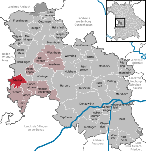
Ederheim
Municipality in Bavaria, Germany
Distance: Approx. 4170 meters
Latitude and longitude: 48.81666667,10.46666667
Ederheim is a municipality in the district of Donau-Ries in Bavaria in Germany.

Reimlingen
Municipality in Bavaria, Germany
Distance: Approx. 4356 meters
Latitude and longitude: 48.81666667,10.51666667
Reimlingen is a municipality in the district of Donau-Ries in Bavaria in Germany.
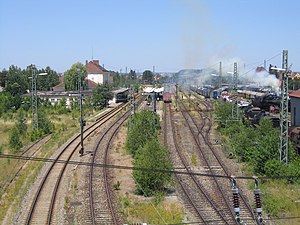
Bavarian Railway Museum
Museum in Nördlingen
Distance: Approx. 797 meters
Latitude and longitude: 48.85030556,10.4995
The Bavarian Railway Museum (Bayerisches Eisenbahnmuseum or BEM) is a railway museum based in the old locomotive sheds at Nördlingen station in Bavaria, Germany. It is home to more than 100 original railway vehicles and has been located in the depot (Bahnbetriebswerk or Bw) at Nördlingen since 1985.

Rieskrater Museum
Geological museum in Nördlingen, Germany
Distance: Approx. 332 meters
Latitude and longitude: 48.853943,10.486919
The Rieskrater Museum, sometimes known in English as the Ries Crater Museum, focuses on meteors and their collisions with Earth. The museum is housed in a 16th-century barn in Nördlingen, Germany which was part of the medieval city's center. The area (Nördlinger Ries) is the location of a meteor's impact with Earth c.
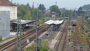
Nördlingen station
Railway station in Bavaria, Germany
Distance: Approx. 666 meters
Latitude and longitude: 48.85083333,10.49777778
Nördlingen railway station is a Deutsche Bahn railway station in Nördlingen, Bavaria, Germany.

Ofnet Caves
Nature reserve in Bavaria, Germany
Distance: Approx. 4592 meters
Latitude and longitude: 48.81861111,10.45027778
The Ofnet Caves (German: Ofnethöhlen) are the remains of an underground karst system on the edge of the Nördlinger Ries in Germany. They are located on a limestone hill near Nördlingen, Bavaria. The caves became famous in 1908 when 33 prehistoric human skulls were discovered.
Weather in this IP's area
few clouds
-5 Celsius
-9 Celsius
-5 Celsius
-5 Celsius
1042 hPa
87 %
1042 hPa
978 hPa
10000 meters
1.94 m/s
3.3 m/s
67 degree
12 %

