Country:
Region:
City:
Latitude and Longitude:
Time Zone:
Postal Code:
IP information under different IP Channel
ip-api
Country
Region
City
ASN
Time Zone
ISP
Blacklist
Proxy
Latitude
Longitude
Postal
Route
IPinfo
Country
Region
City
ASN
Time Zone
ISP
Blacklist
Proxy
Latitude
Longitude
Postal
Route
MaxMind
Country
Region
City
ASN
Time Zone
ISP
Blacklist
Proxy
Latitude
Longitude
Postal
Route
Luminati
Country
ASN
Time Zone
Asia/Nicosia
ISP
Primetel PLC
Latitude
Longitude
Postal
db-ip
Country
Region
City
ASN
Time Zone
ISP
Blacklist
Proxy
Latitude
Longitude
Postal
Route
ipdata
Country
Region
City
ASN
Time Zone
ISP
Blacklist
Proxy
Latitude
Longitude
Postal
Route
Popular places and events near this IP address
Kaimakli
Place in Nicosia District, Cyprus
Distance: Approx. 415 meters
Latitude and longitude: 35.18916667,33.38361111
Kaimakli (Greek: Καϊμακλί [kaimaˈkli]; Turkish: Kaymaklı or Büyük Kaymaklı [ˈbyjyc kajmakˈɫɯ]) is a large northeastern suburb of Nicosia, Cyprus. Since 1968, it belongs to the Municipality of Nicosia. Its population in 2011 was 11,564.

Omorfita
Place in Nicosia District, Cyprus
Distance: Approx. 947 meters
Latitude and longitude: 35.19166667,33.375
Omorfita or Kuchuk Kaimakli (Greek: Ομορφίτα [omorˈfita]; Turkish: Küçük Kaymaklı [cyˈtʃyc kajmakˈɫɯ]) is a northeastern quarter of Nicosia, Cyprus. Omorfita has been divided since 1974, its biggest chunk being under the de facto control of Northern Cyprus.

Panagia, Nicosia
Village in Nicosia District, Cyprus
Distance: Approx. 1334 meters
Latitude and longitude: 35.17444444,33.37694444
Pallouriotissa (Greek: Παλλουριώτισσα [locally [palːuˈr̥kotisːa]]) is an area of Nicosia, Cyprus, formerly an independent village, which was annexed to the municipality in 1968. It was subsequently divided into the quarters of Panayia (Panagia) and Saints Constantine and Helen (Agioi Konstantinos kai Eleni). As of 2011, their combined population was 15,607.

Turkish Federated State of Cyprus
1975–1983 state on the region of Northern Cyprus
Distance: Approx. 1445 meters
Latitude and longitude: 35.18333333,33.36666667
The Turkish Federated State of Cyprus (TFSC) was a state in Northern Cyprus, declared in 1975 and existed until 1983. This state was not recognised by the international community. It was succeeded by the Turkish Republic of Northern Cyprus.
Haydar Pasha, Nicosia
Place in Nicosia District, Cyprus
Distance: Approx. 1727 meters
Latitude and longitude: 35.1775,33.36611111
Haydar Pasha (Turkish: Haydarpaşa, Greek: Χαϊδάρ Πασά) is a Neighbourhood, Quarter or Mahalle of Nicosia, Cyprus and the mosque situated therein. Both are named after Haydar Pasha, said to be one of the 12 generals in command of divisions of the Ottoman army at the time of the Ottoman conquest of Nicosia. Each general being posted to a quarter, that quarter was known by his name.

Yeni Jami, Nicosia
Place in Nicosia District, Cyprus
Distance: Approx. 1666 meters
Latitude and longitude: 35.17861111,33.36611111
Yeni Jami is a Neighbourhood, Quarter, Mahalla or Parish of Nicosia, Cyprus and the mosque situated therein after which the Quarter is named. It is spelled Yenicami in Turkish and Γενί Τζαμί in Greek and means "new mosque" in Turkish. At the last Census (2011) it had a population of 3,185,.

Ayios Kassianos, Nicosia
Place in Nicosia District, Cyprus
Distance: Approx. 1535 meters
Latitude and longitude: 35.17694444,33.36916667
Ayios Kassianos is a Neighbourhood, Quarter, Mahalla or Parish of Nicosia, Cyprus and the church situated therein after which the Quarter is named. It is Άγιος Κασσιανός in Greek and Aykasyano in Turkish and also has the historic name Kafesli (lattice or cage). At the last Census (2011) it had a population of 315,.
Taht-el-kale, Nicosia
Place in Nicosia District, Cyprus
Distance: Approx. 1649 meters
Latitude and longitude: 35.17472222,33.37
Taht-el-kale (Greek: Τάχτ Ελ Καλέ; Turkish: Tahtakale) is a neighbourhood, quarter of Nicosia, Cyprus and the mosque situated therein. At the last Census (2011) it had a population of 826, an increase from a population of 611 in 2001. It covers 28 streets in the eastern part of the municipal area of Nicosia, within and without the walls.
Ayios Loukas, Nicosia
Place in Nicosia District, Cyprus
Distance: Approx. 1669 meters
Latitude and longitude: 35.18,33.36527778
Ayios Loukas (St. Luke) is a Neighbourhood, Quarter, Mahalla or Parish of Nicosia, Cyprus and the parish church thereof. The church was dedicated to and named after St.

Famagusta Gate
Gate in the Nicosia walls, Cyprus
Distance: Approx. 1613 meters
Latitude and longitude: 35.1743,33.3712
The Famagusta Gate (Turkish: Mağusa Kapısı) is a gate in the Nicosia walls, Cyprus. It is the chief gate of the city: the Porta Giuliana, or "di sotto" of Fra Stefano Lusignano's " Chorograffia", known as Famagusta Gate in modern times. This construction, in the Venetian style has been copied from the famous Lazaretto Gate of Candia designed by Michael Sammicheli at the beginning of the 16th century, and consists of a vaulted passage through the earthwork rampart of the city with a carefully executed spherical dome, eleven metres (36') in diameter, in its centre.
Haydar Pasha Mosque
Mosque in North Nicosia, Northern Cyprus
Distance: Approx. 1728 meters
Latitude and longitude: 35.1775,33.3661
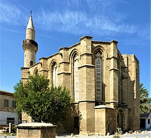
Haydar Pasha Mosque (Greek: Χαϊντάρ-πασά τζαμί Chaintár-pasa Tzamí, Turkish: Haydarpaşa Camii), formerly St. Catherine's Church, is a historic mosque in North Nicosia. It is the most important Gothic building in Nicosia after Ayia Sophia, formerly the Frankish (Latin) cathedral of Nicosia.
Battle of Omorphita
Distance: Approx. 947 meters
Latitude and longitude: 35.19166667,33.375
The Battle of Omorphita was an armed engagement between Greek Cypriot and Turkish–Turkish Cypriot militias and Turkish military forces in December 1963 in the Cypriot town of Omorphita, part of the crisis of 1963.
Weather in this IP's area
scattered clouds
21 Celsius
21 Celsius
21 Celsius
22 Celsius
1010 hPa
78 %
1010 hPa
995 hPa
10000 meters
4.63 m/s
230 degree
40 %
06:33:06
18:46:40

