Country:
 Germany
Region:
City:
Latitude and Longitude:
Time Zone:
Postal Code:
IP information under different IP Channel
ip-api
Country
Region
City
ASN
Time Zone
ISP
Blacklist
Proxy
Latitude
Longitude
Postal
Route
IPinfo
Country
Region
City
ASN
Time Zone
ISP
Blacklist
Proxy
Latitude
Longitude
Postal
Route
MaxMind
Country
Region
City
ASN
Time Zone
ISP
Blacklist
Proxy
Latitude
Longitude
Postal
Route
Luminati
Country
DERegion
rp
City
dernbach
ASN
Time Zone
Europe/Berlin
ISP
NorthC Deutschland GmbH
Latitude
Longitude
Postal
db-ip
Country
Region
City
ASN
Time Zone
ISP
Blacklist
Proxy
Latitude
Longitude
Postal
Route
ipdata
Country
Region
City
ASN
Time Zone
ISP
Blacklist
Proxy
Latitude
Longitude
Postal
Route
Popular places and events near this IP address
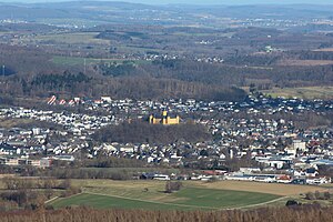
Montabaur
Town in Rhineland-Palatinate, Germany
Distance: Approx. 3098 meters
Latitude and longitude: 50.4375,7.82583333
Montabaur (German pronunciation: [ˈmɔntabaʊɐ]) is a town and the district seat of the Westerwaldkreis in Rhineland-Palatinate, Germany. At the same time, it is also the administrative centre of the Verbandsgemeinde of Montabaur – a kind of collective municipality – to which 24 other communities belong. The town is known throughout the country for its strikingly yellow castle and its InterCityExpress railway station on the Cologne-Frankfurt high-speed rail line.

Wirges
Town in Rhineland-Palatinate, Germany
Distance: Approx. 1719 meters
Latitude and longitude: 50.47416667,7.79527778
Wirges (German pronunciation: [ˈvɪʁɡəs] ) is a town in the Westerwaldkreis in Rhineland-Palatinate, Germany.

Montabaur station
Railway station in Montabaur, Germany
Distance: Approx. 2505 meters
Latitude and longitude: 50.44472222,7.82527778
Montabaur station is a station at the 89.1 kilometre point of the Cologne-Frankfurt high-speed railway and on the Limburg–Siershahn railway (Lower Westerwald Railway) in the German state of Rhineland-Palatinate. The station, which is served by regional and long-distance passenger services and freight traffic, is on the outskirts of the town of Montabaur. It is aligned parallel with Autobahn 3 (A3), which runs immediately to the north.

Bannberscheid
Municipality in Rhineland-Palatinate, Germany
Distance: Approx. 3331 meters
Latitude and longitude: 50.47444444,7.83777778
Bannberscheid is an Ortsgemeinde – a community belonging to a Verbandsgemeinde – in the Westerwaldkreis in Rhineland-Palatinate, Germany.
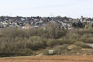
Dernbach, Westerwaldkreis
Municipality in Rhineland-Palatinate, Germany
Distance: Approx. 743 meters
Latitude and longitude: 50.45861111,7.78722222
Dernbach (Westerwald) is a local community (Ortsgemeinde) in the district of Westerwaldkreis in Rhineland-Palatinate, Germany, and part of the municipal association Verbandsgemeinde Wirges. The village is known throughout the country by the three-way interchange A48/A3, called Dernbacher Dreieck, and well known worldwide by the international congregation Poor Handmaids of Jesus Christ, called Dernbacher Schwestern.
Ebernhahn
Municipality in Rhineland-Palatinate, Germany
Distance: Approx. 2505 meters
Latitude and longitude: 50.47277778,7.77
Ebernhahn is an Ortsgemeinde – a community belonging to a Verbandsgemeinde – in the Westerwaldkreis in Rhineland-Palatinate, Germany.

Siershahn
Municipality in Rhineland-Palatinate, Germany
Distance: Approx. 3325 meters
Latitude and longitude: 50.48638889,7.77972222
Siershahn is an Ortsgemeinde – a community belonging to a Verbandsgemeinde – in the Westerwaldkreis in Rhineland-Palatinate, Germany.
Staudt
Municipality in Rhineland-Palatinate, Germany
Distance: Approx. 2257 meters
Latitude and longitude: 50.46722222,7.82666667
Staudt is an Ortsgemeinde – a community belonging to a Verbandsgemeinde – in the Westerwaldkreis in Rhineland-Palatinate, Germany.

Moschheim
Municipality in Rhineland-Palatinate, Germany
Distance: Approx. 4082 meters
Latitude and longitude: 50.4825,7.84166667
Moschheim is an Ortsgemeinde – a community belonging to a Verbandsgemeinde – in the Westerwaldkreis in Rhineland-Palatinate, Germany.
Montabaur (Verbandsgemeinde)
Distance: Approx. 3064 meters
Latitude and longitude: 50.438,7.826
Montabaur is a Verbandsgemeinde ("collective municipality") in the district Westerwaldkreis, in Rhineland-Palatinate, Germany. The seat of the Verbandsgemeinde is in Montabaur.
Wirges (Verbandsgemeinde)
Distance: Approx. 1703 meters
Latitude and longitude: 50.474,7.795
Wirges is a Verbandsgemeinde ("collective municipality") in the district Westerwaldkreis, in Rhineland-Palatinate, Germany. The seat of the Verbandsgemeinde is in Wirges.

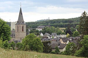
Westerwälder Dom
Church in Rhineland-Palatine, Germany
Distance: Approx. 1589 meters
Latitude and longitude: 50.4729,7.8012
Westerwälder Dom is the common name of the church St. Bonifatius in Wirges in the Westerwald region, Germany. It was built in Gothic revival style from 1885 to 1887.
Weather in this IP's area
broken clouds
12 Celsius
11 Celsius
11 Celsius
13 Celsius
1019 hPa
57 %
1019 hPa
988 hPa
10000 meters
1.6 m/s
2.75 m/s
106 degree
58 %
07:35:33
18:58:29