Country:
 Cyprus
Region:
City:
Latitude and Longitude:
Time Zone:
Postal Code:
IP information under different IP Channel
ip-api
Country
Region
City
ASN
Time Zone
ISP
Blacklist
Proxy
Latitude
Longitude
Postal
Route
IPinfo
Country
Region
City
ASN
Time Zone
ISP
Blacklist
Proxy
Latitude
Longitude
Postal
Route
MaxMind
Country
Region
City
ASN
Time Zone
ISP
Blacklist
Proxy
Latitude
Longitude
Postal
Route
Luminati
Country
CYRegion
03
City
larnaca
ASN
Time Zone
Asia/Nicosia
ISP
Primetel PLC
Latitude
Longitude
Postal
db-ip
Country
Region
City
ASN
Time Zone
ISP
Blacklist
Proxy
Latitude
Longitude
Postal
Route
ipdata
Country
Region
City
ASN
Time Zone
ISP
Blacklist
Proxy
Latitude
Longitude
Postal
Route
Popular places and events near this IP address
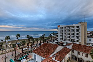
Larnaca
City and municipality in Larnaca District, Cyprus
Distance: Approx. 894 meters
Latitude and longitude: 34.91666667,33.63333333
Larnaca (pronounced ) (Greek: Λάρνακα, romanized: Lárnaka [ˈlarnaka]; Turkish: Larnaka) is a city on the south east coast of Cyprus and the capital of the district of the same name. It is the third-largest city in the country, after Nicosia and Limassol, with a district population of 144,200 in 2015. Larnaca is known for its palm-tree seafront also called Finikoudes (Greek: Φινικούδες) as well as the Church of Saint Lazarus, Hala Sultan Tekke, Kamares Aqueduct, and Larnaca Castle.

Larnaca Salt Lake
Distance: Approx. 2676 meters
Latitude and longitude: 34.9,33.61666667
Larnaca Salt Lake (Greek: Αλυκή Λάρνακας, romanized: Alykí Lárnakas, Turkish: Larnaka Tuz Gölü) is a complex network of four salt lakes (3 of them interconnected) of different sizes to the west of the city of Larnaca. The largest is lake Aliki, followed by lake Orphani, lake Soros and lake Spiro. They form the second largest salt lake in Cyprus after the Limassol Salt Lake.

Larnaca Synagogue
Hasidic synagogue in Larnaca, Cyprus
Distance: Approx. 1082 meters
Latitude and longitude: 34.912787,33.629853
The Larnaca Synagogue or Great Synagogue of Cyprus, also known as the Cyprus Central Synagogue, is an Hasidic Jewish congregation and synagogue, that is located at Apollodorou 4, in Larnaca, Cyprus. Designed in the Modernist style, the synagogue was completed in 2005. It is the largest and oldest of the five synagogues Cyrus.
MS Zenobia
RO-RO ferry that capsized and sank near Larnaca, Cyprus
Distance: Approx. 2702 meters
Latitude and longitude: 34.8894,33.6508
MS Zenobia was a Swedish-built Challenger-class RO-RO ferry launched in 1979 that capsized and sank in the Mediterranean Sea, close to Larnaca, Cyprus, in June 1980. She now rests on her port side in approximately 42 meters (138 ft) of water and was named by The Times, and many others, as one of the top ten wreck diving sites in the world.

American Academy of Larnaca
Private school in Cyprus
Distance: Approx. 1342 meters
Latitude and longitude: 34.917152,33.628139
The American Academy Larnaca is a non-profit private school in Larnaca, Cyprus offering pre-school to University entrance education. It is a selective, co-educational, independent school, registered under the Private Schools’ Law, 1971, of the Republic of Cyprus. The school was founded in 1908.

Church of Saint Lazarus, Larnaca
Church in Larnaca, Cyprus
Distance: Approx. 640 meters
Latitude and longitude: 34.911495,33.634793
The Church of Saint Lazarus (Greek: Ιερός Ναός Αγίου Λαζάρου, Ierós Naós Agíou Lazárou) is a late-9th century church in Larnaca, Cyprus. It belongs to the Church of Cyprus, an autocephalous Greek Orthodox Church. The Church of Saint Lazarus is named for New Testament figure Lazarus of Bethany, the subject of a miracle recounted in the Gospel of John, in which Jesus raises him from the dead.

Armenian Genocide Memorial in Larnaca
Distance: Approx. 514 meters
Latitude and longitude: 34.9163,33.6385
The Armenian Genocide Memorial in Larnaca, Cyprus, is a monument dedicated to the martyrs and survivors of the Armenian genocide of 1915-1923. It is located at Larnaca’s seafront and marks the spot where thousands of Armenian refugees fleeing the atrocities of the Genocide first landed in Cyprus (at Larnaca Port). Its position is adjacent to the entrance to Larnaca’s present-day marina.

Kition
Ancient Helleno-Phoenician city in Cyprus
Distance: Approx. 1578 meters
Latitude and longitude: 34.9233,33.6305
Kition (Ancient Greek: Κίτιον, Kition; Latin: Citium; Egyptian: kꜣṯꜣj; Phoenician: 𐤊𐤕, KT, or 𐤊𐤕𐤉, KTY;) was an Ancient Greek city-kingdom on the southern coast of Cyprus (in present-day Larnaca), one of the Ten city-kingdoms of Cyprus. Its most famous, and probably only known, resident was Zeno of Kition, born c.

Sourp Stepanos Church, Larnaca
Distance: Approx. 616 meters
Latitude and longitude: 34.914918,33.635626
Sourp Stepanos Church (Armenian: Սուրբ Ստեփանոս Եկեղեցի; Saint Stephen) is the Armenian Apostolic church in Larnaca, Cyprus. The church is located in the town centre of Larnaca and was originally built in 1909 as a small chapel in memory of Adana's patron saint, Sourp Stepanos (Saint Stephen), by Armenian refugees who fled the Adana massacre. Following a fund-raising in 1912 and 1913, the church was completed on 1 April 1913.

Larnaca Armenian school
Armenian school in Larnaca, Cyprus
Distance: Approx. 601 meters
Latitude and longitude: 34.91444444,33.63555556
The Nareg Armenian School (Greek: Αρμενικό Σχολείο Ναρέκ; Armenian: Նարեկ հայկական վարժարան), also known as the Larnaca Armenian School, is located in Larnaca. As of 1972, it has been called Nareg, after Saint Krikor Naregatsi. It's located on 21, Armenian church street in central Larnaca, next to the Sourp Stepanos church.

Larnaca District Archaeological Museum
Museum
Distance: Approx. 1055 meters
Latitude and longitude: 34.9191,33.6334
Larnaca District Museum is a museum in Larnaca, Cyprus that has displays that show the "historical development of the city of Kition and the District of Larnaka in general." It was inaugurated in 1969. and was formerly named Larnaca District Archaeological Museum. It is controlled by the Department of Antiquities.

Pierides Museum
Distance: Approx. 635 meters
Latitude and longitude: 34.9161,33.6363
The Pierides Museum is a museum in Larnaca, Cyprus that was founded by the Pierides Foundation. It is the nation's oldest private museum. The placard on the museum building says (as of 2013) "Perides Museum - Bank of Cyprus Cultural Foundation".
Weather in this IP's area
few clouds
22 Celsius
22 Celsius
22 Celsius
23 Celsius
1010 hPa
71 %
1010 hPa
1010 hPa
10000 meters
3.6 m/s
280 degree
20 %
06:32:06
18:45:35