Country:
Region:
City:
Latitude and Longitude:
Time Zone:
Postal Code:
IP information under different IP Channel
ip-api
Country
Region
City
ASN
Time Zone
ISP
Blacklist
Proxy
Latitude
Longitude
Postal
Route
Luminati
Country
Region
84
City
copenhagen
ASN
Time Zone
Europe/Copenhagen
ISP
GlobalConnect A/S
Latitude
Longitude
Postal
IPinfo
Country
Region
City
ASN
Time Zone
ISP
Blacklist
Proxy
Latitude
Longitude
Postal
Route
db-ip
Country
Region
City
ASN
Time Zone
ISP
Blacklist
Proxy
Latitude
Longitude
Postal
Route
ipdata
Country
Region
City
ASN
Time Zone
ISP
Blacklist
Proxy
Latitude
Longitude
Postal
Route
Popular places and events near this IP address
Ydre Østerbro
District of Copenhagen, Denmark
Distance: Approx. 703 meters
Latitude and longitude: 55.72,12.5628
Ydre Østerbro (lit. English: Outer Østerbro) is an area in Copenhagen, Denmark. It is the part of the district of Østerbro located farthest from the City Centre.
Østerbro
Districts of Copenhagen
Distance: Approx. 786 meters
Latitude and longitude: 55.711,12.578
Østerbro (Danish pronunciation: [ˈøstɐˌpʁoˀ]) is one of the 10 official districts of Copenhagen Municipality, Denmark. It is located just north of the city centre, outside the old city gate Østerport which, after it was moved around 1700, used to be located close to present-day Østerport Station. From the beginning, Østerbro has been a wealthy district, and it remains one of the most affluent areas in Copenhagen.
Danish Defence Research Establishment
Distance: Approx. 36 meters
Latitude and longitude: 55.7178,12.5729
Danish Defence Research Establishment (Danish: Forsvarets Forskningstjeneste) short FOFT was the consultative, guiding and promotion organ in the scientific and technical area for the Danish Armed Forces. It was an independent institute under the Ministry of Defence. FOFT was located on Svanemøllens Barracks in Copenhagen.

Svanemøllen railway station
Commuter railway station in Copenhagen, Denmark
Distance: Approx. 379 meters
Latitude and longitude: 55.71555556,12.57805556
Svanemøllen station is an S-train station serving the northern part of the district of Østerbro in Copenhagen, Denmark. It is served by the A, B, Bx, C, and E services of Copenhagen's S-train network. Svanemøllen station was inaugurated on 15 May 1934 simultaneously with the opening of the Boulevardbanen between Østerport station and Copenhagen Central Station also known Røret (literally: the tube).

Denmark–South Africa relations
Bilateral relations
Distance: Approx. 660 meters
Latitude and longitude: 55.7234,12.572
Denmark–South Africa relations refers to the bilateral relations between Denmark and South Africa. Denmark has an embassy in Pretoria and South Africa has an embassy in Copenhagen. Queen Margrethe II visited to South Africa in 1996.
Danish Society for Nature Conservation
Distance: Approx. 757 meters
Latitude and longitude: 55.7107,12.5729
The Danish Society for Nature Conservation, in Danish Danmarks Naturfredningsforening, founded 1911, is an incorporated non-governmental organization based in Denmark. It works for environmental protection and biodiversity, improved environmental legislation, consideration for the natural environment in public planning, and public access to natural resources. The Society is a member of the International Union for Conservation of Nature.

Svanemølle Beach
Beach in Copenhagen, Denmark
Distance: Approx. 731 meters
Latitude and longitude: 55.7201,12.5838
Svanemølle Beach (Danish: Svanemøllestranden) is an urban beach situated in the Østerbro district of Copenhagen, Denmark. It is situated in the bottom of the Svanemølle Bay, off Strandpromenaden, a promenade that follows the coast between Copenhagen's Nordhavn area to the south and Tuborg Havn in Hellerup to the north. Svanemøllen Marina and the Svanemølle Power Station are located just south of the beach.

Kildevæld Church
Church in Copenhagen, Denmark
Distance: Approx. 538 meters
Latitude and longitude: 55.71383333,12.5675
Kildevæld Church (Danish: Kildevældskirken) is a Lutheran church in the Østerbro district of Copenhagen, Denmark. It belongs to the church of Denmark. Completed in 1932, it is one of many churches in Copenhagen which was built by the Church Foundation.

Zion's Church, Copenhagen
Church in Copenhagen, Denmark
Distance: Approx. 756 meters
Latitude and longitude: 55.71130556,12.57805556
Zion's Church (Danish: Sions Kirke) is a Lutheran church on Østerbrogade, just south of Svanemøllen station, in the Østerbro district of Copenhagen, Denmark. It was completed in 1896 to a design by Valdemar Koch, making it the second oldest church in Østerbro.
Kildevældsparken
Distance: Approx. 508 meters
Latitude and longitude: 55.7145,12.567
Kildevældsparken is a small park in the outer Østerbro district of Copenhagen, Denmark. It is bounded by Vognmandsmarken/Bellmansgade and Borgervænget. It has an area of 0.77 hectares and contains a lake.

Royal Danish Defence College
Distance: Approx. 4 meters
Latitude and longitude: 55.717525,12.57314722
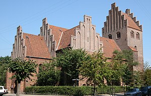
The Royal Danish Defence College (Danish: Forsvarsakademiet; FAK) is an independent authority in the Armed Forces under the Armed Forces Commander's Defense Command, which provides training, research, advice, and consultancy services in core military areas. The activities of the Defense Academy primarily target the staff of the Armed Forces, but much of the research is done in collaboration with other research institutions. The head of the Defense Academy typically has the rank of Major General or Rear Admiral.

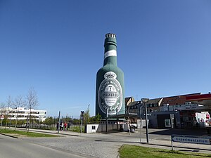
Tuborg Bottle
Distance: Approx. 728 meters
Latitude and longitude: 55.72330556,12.57844444
The Tuborg Bottle (Danish: Tuborgflasken) is a 26 metres tall landmark shaped as a Tuborg bottle located close to Tuborg's former brewery site, now Tuborg Havn, Hellerup, in the northern suburbs of Copenhagen, Denmark.
Weather in this IP's area
broken clouds
12 Celsius
11 Celsius
11 Celsius
12 Celsius
1022 hPa
84 %
1022 hPa
1021 hPa
10000 meters
10.8 m/s
270 degree
75 %
07:20:27
16:26:01
