Country:
 Denmark
Region:
City:
Latitude and Longitude:
Time Zone:
Postal Code:
IP information under different IP Channel
ip-api
Country
Region
City
ASN
Time Zone
ISP
Blacklist
Proxy
Latitude
Longitude
Postal
Route
IPinfo
Country
Region
City
ASN
Time Zone
ISP
Blacklist
Proxy
Latitude
Longitude
Postal
Route
MaxMind
Country
Region
City
ASN
Time Zone
ISP
Blacklist
Proxy
Latitude
Longitude
Postal
Route
Luminati
Country
DKRegion
84
City
copenhagen
ASN
Time Zone
Europe/Copenhagen
ISP
GlobalConnect A/S
Latitude
Longitude
Postal
db-ip
Country
Region
City
ASN
Time Zone
ISP
Blacklist
Proxy
Latitude
Longitude
Postal
Route
ipdata
Country
Region
City
ASN
Time Zone
ISP
Blacklist
Proxy
Latitude
Longitude
Postal
Route
Popular places and events near this IP address
Dansk Sprognævn
Distance: Approx. 425 meters
Latitude and longitude: 55.6781,12.5647
Dansk Sprognævn ([ˌtænˀsk ˈspʁɔwˌnewˀn] "Danish Language Council") is the official regulatory body of the Danish language as a part of the Danish Ministry of Culture and is located in Bogense. It was established in 1955. The committee has three main objectives: to follow the development of the language to answer inquiries about the Danish language and its use to update the official Danish dictionary, Retskrivningsordbogen The working members of the committee follow written and broadcast media, read books to keep track of new words and record their usage.

Forum Copenhagen
Indoor arena
Distance: Approx. 405 meters
Latitude and longitude: 55.68055556,12.55222222
Forum Copenhagen (Danish: Forum København) is a large multi-purpose, rentable indoor arena located in Frederiksberg, Denmark. It hosts a large variety of concerts, markets, exhibitions and other events. The venue can hold up to 10,000 people depending on the event.

Agency for Culture and Palaces (Denmark)
Distance: Approx. 431 meters
Latitude and longitude: 55.677975,12.56470556
The Danish Agency for Culture and Palaces (Danish: Slots- og Kulturstyrelsen) is an agency under the aegis of the Danish Ministry of Culture. The agency carries out the cultural policies of the Danish government within the visual and performing arts, music, literature, museums, historical and cultural heritage, broadcasting, libraries and all types of printed and electronic media. It works internationally in all fields, and increased internationalisation of Danish arts and cultural life is a top priority.
Skt. Jørgens Gymnasium
Distance: Approx. 220 meters
Latitude and longitude: 55.67861111,12.55527778
Skt. Jørgens Gymnasium (1858–1991) was a Danish high school located in Frederiksberg, Copenhagen. It was established in 1858 as Frk.
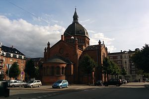
St. Mark's Church, Copenhagen
Church in Copenhagen, Denmark
Distance: Approx. 364 meters
Latitude and longitude: 55.67988889,12.55263889
St. Mark's Church (Danish: Sankt Markus Kirke) is a church at the end of Julius Thomsens Plads in the Frederiksberg district of Copenhagen, Denmark.
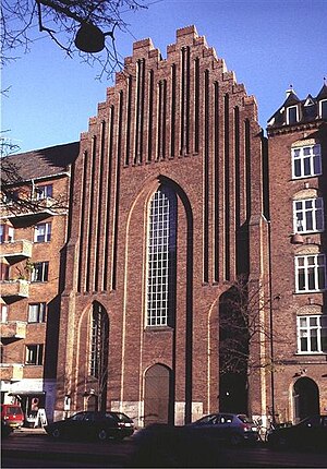
Bethlehem Church, Copenhagen
Church in Copenhagen, Denmark
Distance: Approx. 416 meters
Latitude and longitude: 55.68313889,12.55686111
Bethlehem Church (Danish: Bethlehemskirken) is a church in the Nørrebro district of Copenhagen, Denmark, located on Åboulevard, close to Peblinge Lake and the municipal border with Frederiksberg. Peder Vilhelm Jensen-Klint made the first sketches for the church but after his death it was completed by his son, Kaare Klint, and built from 1935 to 1937. Its style is remniscient of Grundtvig's Church, Jensen Klint's most famous work, which was also completed posthumously by Kaare Klint, although on a much smaller scale.
Danish Arts Foundation
Distance: Approx. 425 meters
Latitude and longitude: 55.6781,12.5647
The Danish Arts Foundation (Danish: Statens Kunstfond) is the principal Danish government funded arts foundation founded by a special Law on 27 May 1964. Statens Kunstfond alongside the da:Statens Kunstråd (English sometimes State Arts Council now Danish Agency for Culture) allocates funds provided by the Ministry of Culture (da:Kulturministeriet). It is overseen and administered by the da:Kulturstyrelsen (Danish Cultural Authority) which is an administrative unit of the Ministry of Culture.

Lake Pavilion, Copenhagen
Distance: Approx. 276 meters
Latitude and longitude: 55.68194444,12.55916667
The Lake Pavilion (Danish: Søpavillonen) is a historic building at The Lakes in central Copenhagen, Denmark. Situated on the north side of Gyldenløvesgade, on the embankment that separates Peblinge Lake and Sankt Jørgens Lake, it was completed in 1895 to a Historicist design by Vilhelm Dahlerup and listed in 1984.
Vodroffsvej
Distance: Approx. 326 meters
Latitude and longitude: 55.6777,12.5543
Vodroffsvej is a street in the Frederiksberg district of Copenhagen, Denmark. It follows the western shore of St. Jørgen's Lake, linking Gammel Kongevej in the south with Rosenørns Allé in the north.
Vesterbro Pharmacy
Building in Copenhagen
Distance: Approx. 171 meters
Latitude and longitude: 55.67823889,12.55995556
Vesterbro Pharmacy (Danish: Vesterbro Apotek) operated from 1795 to 1992 in the Vesterbro district of Copenhagen, Denmark. Its former buildings on Vesterbrogade, one facing the street and two in the courtyard on the rear, were listed in 1972; all three date from the second half of the 19th century. Two other, still active pharmacies are found in the Vesterbro area.

Gyldenløvesgade
Distance: Approx. 246 meters
Latitude and longitude: 55.6805,12.5619
Gyldenløvesgade is a street in central Copenhagen, Denmark. It runs from Jarmers Plads in the south east to a Y junction at the western side of The Lakes, linking H. C. Andersens Boulevard with Aaboulevarden and Rosenørns Allé. The last section of the street runs on an embankment which separates Peblinge Lake to the north from Sankt Jørgen's Lake to the south.

Martin's Church, Copenhagen
Church in Copenhagen, Denmark
Distance: Approx. 178 meters
Latitude and longitude: 55.6799,12.55565
Martin's Church (Danish: Martinskirken), located on Martinsvej in Frederiksberg, just west of St. Jørgen's Lake, is one of the only two church buildings in the Evangelical Lutheran Free Church in Copenhagen, Denmark. It was built in 1877 and refurbished in 1998–99.
Weather in this IP's area
clear sky
13 Celsius
12 Celsius
11 Celsius
14 Celsius
1027 hPa
87 %
1027 hPa
1026 hPa
10000 meters
4.53 m/s
7.99 m/s
9 degree
9 %
06:44:07
19:25:09