Country:
 Czech Republic
Region:
City:
Latitude and Longitude:
Time Zone:
Postal Code:
IP information under different IP Channel
ip-api
Country
Region
City
ASN
Time Zone
ISP
Blacklist
Proxy
Latitude
Longitude
Postal
Route
IPinfo
Country
Region
City
ASN
Time Zone
ISP
Blacklist
Proxy
Latitude
Longitude
Postal
Route
MaxMind
Country
Region
City
ASN
Time Zone
ISP
Blacklist
Proxy
Latitude
Longitude
Postal
Route
Luminati
Country
CZASN
Time Zone
Europe/Prague
ISP
Webglobe, s.r.o.
Latitude
Longitude
Postal
db-ip
Country
Region
City
ASN
Time Zone
ISP
Blacklist
Proxy
Latitude
Longitude
Postal
Route
ipdata
Country
Region
City
ASN
Time Zone
ISP
Blacklist
Proxy
Latitude
Longitude
Postal
Route
Popular places and events near this IP address
Third Czechoslovak Republic
Republic in Central Europe from 1945 to 1948
Distance: Approx. 705 meters
Latitude and longitude: 50.0833,14.4667
The Third Czechoslovak Republic (Czech: Třetí Československá republika; Slovak: Tretia česko-slovenská republika), officially the Czechoslovak Republic (Czech: Československá republika; Slovak: Československá republika), was a sovereign state from April 1945 to February 1948 following the end of World War II. After the fall of Nazi Germany, the country was reformed and reassigned coterminous borders as its pre-war predecessor state, First Czechoslovak Republic; it likewise restored the predecessor's international recognition. Due to the rise of the Communist Party of Czechoslovakia (KSČ), Czechoslovakia fell within the Soviet sphere of influence, and this circumstance dominated any plans or strategies for post-war reconstruction. Consequently, the political and economic organisation of Czechoslovakia became largely a matter of negotiations between Edvard Beneš and the Communist Party members exiled in Moscow.
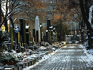
Olšany Cemetery
Graveyard in Prague, Czech Republic
Distance: Approx. 720 meters
Latitude and longitude: 50.080556,14.470556
Olšany Cemeteries (Czech: Olšanské hřbitovy, German: Wolschaner Friedhof) is the largest graveyard in Prague, Czech Republic, once laid out for as many as two million burials. The graveyard is particularly noted for its many remarkable Art Nouveau monuments.

Žižkov Television Tower
TV tower in Prague, Czech Republic
Distance: Approx. 775 meters
Latitude and longitude: 50.08083333,14.45138889
The Žižkov Television Tower (Czech: Žižkovský vysílač) is a transmitter tower built in Prague between 1985 and 1992. Designed by the architect Václav Aulický and the structural engineer Jiří Kozák, it stands high above the city's traditional skyline from its position on top of a hill in the district of Žižkov, from which it takes its name. The tower is an example of high-tech architecture.
Czech and Slovak Federative Republic
Republic in Central Europe between 1990 and 1992
Distance: Approx. 707 meters
Latitude and longitude: 50.08333333,14.46666667
After the Velvet Revolution in late-1989, Czechoslovakia adopted the official short-lived country name Czech and Slovak Federative Republic (Czech: Česká a Slovenská Federativní Republika, Slovak: Česká a Slovenská Federatívna Republika; ČSFR) during the period from 23 April 1990 until 31 December 1992, after which the country was peacefully dissolved into the Czech Republic and the Slovak Republic.

Czech Socialist Republic
Part of Czechoslovakia between 1969 and 1990
Distance: Approx. 705 meters
Latitude and longitude: 50.0833,14.4667
The Czech Socialist Republic (Czech: Česká socialistická republika, ČSR) was a republic within the Czechoslovak Socialist Republic. The name was used from 1 January 1969 to November 1989, when the previously unitary Czechoslovak state changed into a federation. From 1990 to 1992, the Czech Republic (Czech: Česká republika, ČR) existed as a federal subject within the Czech and Slovak Federative Republic, and later became the independent Czech Republic.

Jiřího z Poděbrad (Prague Metro)
Prague metro station
Distance: Approx. 786 meters
Latitude and longitude: 50.07783028,14.450295
Jiřího z Poděbrad (Czech pronunciation: [ˈjɪr̝iːɦo ˈspoɟɛbrat]) is a Prague Metro station on Line A, located in Vinohrady, Prague 3. In January 2023 it closed for reconstruction.

Flora (Prague Metro)
Prague metro station
Distance: Approx. 41 meters
Latitude and longitude: 50.07763056,14.46123611
Flora is a Prague Metro station on Line A. It is located under the shopping mall Atrium Flora, on the border of the Vinohrady and Žižkov districts near the Olšany Cemetery. The station was opened on 19 December 1980 as part of the extension of the line between Náměstí Míru and Želivského.

Church of Saint Roch, Žižkov
Distance: Approx. 506 meters
Latitude and longitude: 50.0825,14.46027778
The Church of Saint Roch, located on Olšany Square (Czech: Olšanské náměstí), is the oldest church in present-day Žižkov, a cadastral district of Prague, Czech Republic. The Baroque structure was built between 1680 and 1682 by Jan Hainric, probably according to plans by the renowned French architect Jean Baptiste Mathey.
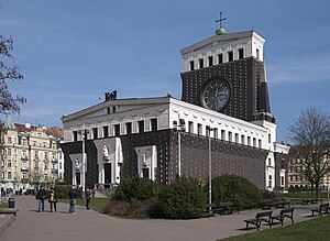
Church of the Most Sacred Heart of Our Lord
Distance: Approx. 764 meters
Latitude and longitude: 50.07803333,14.45060556
The Church of the Most Sacred Heart of Our Lord (Czech: Kostel Nejsvětějšího Srdce Páně) is a Roman Catholic church at Jiřího z Poděbrad Square in Prague's Vinohrady district. It was built between 1929 and 1932 and designed by the Slovene architect Jože Plečnik. Plečnik found the inspiration for this construction in old Christian and ancient patterns.

Vinohrady tram depot
Historic tram depot
Distance: Approx. 334 meters
Latitude and longitude: 50.075,14.4611
Vinohrady tram depot (Czech: Vozovna Královské Vinohrady) is a former tram and trolleybus depot at Vinohrady that was part of the Prague tram network from 1897. The last Prague trolley bus left from here in 1972.

Parukářka Park
Mountain and park in Prague, Czech Republic
Distance: Approx. 752 meters
Latitude and longitude: 50.08475278,14.46162778
Parukářka Park is a park in Žižkov, Prague, Czech Republic.

Jiřího z Poděbrad Square
Distance: Approx. 786 meters
Latitude and longitude: 50.078,14.4503
Jiřího z Poděbrad Square (George of Poděbrady Square, Czech: náměstí Jiřího z Poděbrad) is located in the Vinohrady district of Prague, the capital of the Czech Republic. It is dominated by the 1932 Art Nouveau Church of the Most Sacred Heart of Our Lord in its centre. The square is largely an urban park.
Weather in this IP's area
few clouds
18 Celsius
18 Celsius
17 Celsius
20 Celsius
1022 hPa
75 %
1022 hPa
990 hPa
10000 meters
4.12 m/s
50 degree
20 %
06:41:24
19:11:55