Country:
Region:
City:
Latitude and Longitude:
Time Zone:
Postal Code:
IP information under different IP Channel
ip-api
Country
Region
City
ASN
Time Zone
ISP
Blacklist
Proxy
Latitude
Longitude
Postal
Route
Luminati
Country
Region
37
City
takamatsu
ASN
Time Zone
Asia/Tokyo
ISP
STNet, Incorporated
Latitude
Longitude
Postal
IPinfo
Country
Region
City
ASN
Time Zone
ISP
Blacklist
Proxy
Latitude
Longitude
Postal
Route
db-ip
Country
Region
City
ASN
Time Zone
ISP
Blacklist
Proxy
Latitude
Longitude
Postal
Route
ipdata
Country
Region
City
ASN
Time Zone
ISP
Blacklist
Proxy
Latitude
Longitude
Postal
Route
Popular places and events near this IP address

Kanda Station (Tokyo)
Railway and metro station in Tokyo, Japan
Distance: Approx. 170 meters
Latitude and longitude: 35.691731,139.771264
Kanda Station (神田駅, Kanda-eki) is a railway station in Chiyoda, Tokyo, Japan. East Japan Railway Company (JR East) and Tokyo Metro operate individual portions of the station.
Uchi-Kanda
District in Tokyo, Japan
Distance: Approx. 454 meters
Latitude and longitude: 35.691,139.765
Uchi-Kanda (内神田) is a district in Chiyoda, Tokyo, Japan. As of March 1, 2008, its population is 1,277. The Uchi-Kanda district is located in the northern part of Chiyoda, to the west of Kanda Station.

Kajichō, Tokyo
District in Tokyo, Japan
Distance: Approx. 147 meters
Latitude and longitude: 35.6917,139.7709
Kajichō (鍛冶町) is a district of Chiyoda, Tokyo, Japan. It consists of Kajichō 1-chōme and Kajichō 2-chōme. This article also explains about Kanda-Kajichō (神田鍛冶町), which today only has Kanda-Kajichō 3-chōme.

Muromachi, Tokyo
District in Chūō, Tokyo, Japan
Distance: Approx. 496 meters
Latitude and longitude: 35.68664,139.77252
Muromachi (室町), or officially Nihonbashi-Muromachi (日本橋室町), is a district of Chūō, Tokyo, Japan. It formerly belonged to the Nihonbashi Ward (日本橋区), which corresponds to the present-day Nihonbashi area. Muromachi is a business district, home to a number of long-established companies.
Kitanorimonochō, Tokyo
District of Chiyoda, Tokyo, Japan
Distance: Approx. 410 meters
Latitude and longitude: 35.6925,139.77388889
Kitanorimonochō (北乗物町), or officially Kanda-Kitanorimonochō (神田北乗物町), is a district of Chiyoda, Tokyo, Japan. As of April 1, 2007, its population is 90. Its postal code is 101-0036.
Higashikonyachō, Tokyo
District of Chiyoda, Tokyo, Japan
Distance: Approx. 525 meters
Latitude and longitude: 35.693,139.775
Higashikonyachō (東紺屋町), officially Kanda-Higashikonyachō (神田東紺屋町), is a district of Chiyoda, Tokyo, Japan. As of April 1, 2007, its population is 55. Its postal code is 101–0034.
Japan Professional School of Education
Distance: Approx. 532 meters
Latitude and longitude: 35.69502778,139.76777778
Japan Professional School of Education (日本教育大学院大学, Nihon kyōiku daigaku-in gakuin daigaku) was a private university in Chiyoda, Tokyo, Japan, established in 2006.
Kamiyashiki of Matsudaira Tadamasa
Daimyo yashiki in Edo, Japan
Distance: Approx. 434 meters
Latitude and longitude: 35.68694444,139.76833333
The Kamiyashiki of Matsudaira Tadamasa (松平忠昌の上屋敷, Matsudaira Tadamasa no kamiyashiki) was a large residential complex that was located outside Edo Castle in 17th century Japan.

Shin-Nihombashi Station
Railway and metro station in Tokyo, Japan
Distance: Approx. 472 meters
Latitude and longitude: 35.6886,139.7746
Shin-Nihombashi Station (新日本橋駅, Shin-Nihonbashi-eki) is a railway station in Chūō, Tokyo, Japan, operated by East Japan Railway Company (JR East).

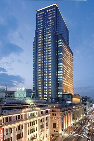
Nihonbashi Mitsui Tower
Skyscraper in Japan
Distance: Approx. 492 meters
Latitude and longitude: 35.68694444,139.77305556
The Nihonbashi Mitsui Tower (日本橋三井タワー) is a skyscraper located in Chūō, Tokyo, Japan. The 192-metre, 34-storey building is primarily used for office space with the upper floors occupied by a hotel. Its construction was completed in 2005.

Mandarin Oriental, Tokyo
Hotel in Nihonbashi, Chuo, Tokyo.
Distance: Approx. 495 meters
Latitude and longitude: 35.68690556,139.77305556
Mandarin Oriental, Tokyo is a luxury hotel located in the Nihonbashi Mitsui Tower in Tokyo’s Nihonbashi neighborhood, close to Tokyo Station and Tokyo Stock Exchange. The hotel, opened on 2 December 2005, is managed by Mandarin Oriental Hotel Group. The hotel contains 178 guestrooms and suites as well as ten restaurants and bars.
Tokiwa Bridge
Bridge in Tokyo, Japan
Distance: Approx. 500 meters
Latitude and longitude: 35.68611111,139.77027778
The Tokiwabridge (常盤橋) is a bridge over the Nihonbashi River between Ōtemachi, Chiyoda, Tokyo and Nihonbashi Motoishi-chō, Chūō, Tokyo. There are actually two separate "Tokiwa Bridges": a pedestrian-only stone bridge which led to a gate of Edo Castle and a road bridge constructed after the 1923 Great Kanto Earthquake located 70 meters away. Both of these bridges are made from stone, have a double arch structure.
Weather in this IP's area
broken clouds
12 Celsius
11 Celsius
11 Celsius
13 Celsius
1027 hPa
61 %
1027 hPa
1025 hPa
10000 meters
4.63 m/s
340 degree
75 %
06:11:45
16:38:02


