Country:
 Singapore
Region:
City:
Latitude and Longitude:
Time Zone:
Postal Code:
IP information under different IP Channel
ip-api
Country
Region
City
ASN
Time Zone
ISP
Blacklist
Proxy
Latitude
Longitude
Postal
Route
IPinfo
Country
Region
City
ASN
Time Zone
ISP
Blacklist
Proxy
Latitude
Longitude
Postal
Route
MaxMind
Country
Region
City
ASN
Time Zone
ISP
Blacklist
Proxy
Latitude
Longitude
Postal
Route
Luminati
Country
SGASN
Time Zone
Asia/Singapore
ISP
NETPLUZ HOLDINGS PRIVATE LIMITED
Latitude
Longitude
Postal
db-ip
Country
Region
City
ASN
Time Zone
ISP
Blacklist
Proxy
Latitude
Longitude
Postal
Route
ipdata
Country
Region
City
ASN
Time Zone
ISP
Blacklist
Proxy
Latitude
Longitude
Postal
Route
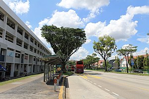
Popular places and events near this IP address

Serangoon
Planning Area and HDB Town in North-East Region ----, Singapore
Distance: Approx. 1297 meters
Latitude and longitude: 1.36361111,103.8675
Serangoon ( sə-RANG-goon) is a planning area and residential town located in the North-East Region of Singapore. Serangoon is bordered by these planning areas – Sengkang to the north, Hougang to the east, Ang Mo Kio and Bishan to the west, as well as Toa Payoh to the south. Serangoon planning area has a total of seven subzones: Serangoon Central, Lorong Chuan, Upper Paya Lebar, Serangoon Garden, Serangoon North, Seletar Hills and Serangoon North Industrial Estate.

Ang Mo Kio MRT station
Mass Rapid Transit station in Singapore
Distance: Approx. 1584 meters
Latitude and longitude: 1.37001667,103.84945
Ang Mo Kio MRT station is an above-ground Mass Rapid Transit (MRT) station on the North South Line in Ang Mo Kio, Singapore. Located at the junction of Ang Mo Kio Avenue 3 and Ang Mo Kio Avenue 8, beside Ang Mo Kio Town Garden East, the station is connected to AMK Hub, Ang Mo Kio Bus Interchange and the Ang Mo Kio Town Centre via an underground walkway. Opened on 7 November 1987, Ang Mo Kio station is one of the five stations that collectively make up Singapore's oldest MRT stations.
Deyi Secondary School
Government-aided school in Ang Mo Kio, Singapore
Distance: Approx. 1661 meters
Latitude and longitude: 1.3662,103.8505
Deyi Secondary School is a co-educational government secondary school located in Ang Mo Kio, Singapore. Founded in January 1980, having 1200~ pupils. the school is remarked for its niche development in performing arts.

Masjid Al-Istiqamah
Distance: Approx. 1513 meters
Latitude and longitude: 1.36922222,103.87558333
The Al-Istiqamah Mosque (Malay: Masjid Al-Istiqamah) is a mosque in Serangoon, Singapore which was completed in 1999. It is located at Serangoon North Estate, at the corner of Yio Chu Kang Road and Ang Mo Kio Avenue 3, with the front entrance at Serangoon North Avenue 2.

Anderson Secondary School
Autonomous school
Distance: Approx. 1290 meters
Latitude and longitude: 1.37483333,103.85141667
Anderson Secondary School (AndSS) is a co-educational government autonomous school in Ang Mo Kio, Singapore offering education for Secondary 1 to Secondary 5. It became an autonomous school in 1994 and was one of the pioneer autonomous schools in Singapore.
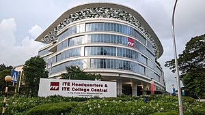
ITE College Central
Public school in Ang Mo Kio, Singapore
Distance: Approx. 813 meters
Latitude and longitude: 1.3775,103.8564
ITE College Central (ITECC) is a post-secondary education institution and statutory board under the purview of the Ministry of Education in Singapore. It is one of the Institute of Technical Education's three colleges under the "One ITE System, Three Colleges" Governance and Education Model. The college also houses the headquarters of the Institute of Technical Education.
RAF Chia Keng
Royal Air Force station in Singapore
Distance: Approx. 1338 meters
Latitude and longitude: 1.36777778,103.87305556
RAF Chia Keng was a non-flying Royal Air Force station located in Serangoon, Singapore from 1948 to 1971 serving as a satellite station for RAF Changi. It was one of the two British GCHQ radio receiving stations in Singapore, the other one being RAF Jurong which served as a satellite station for RAF Tengah. The station was closed in 1971, later being demolished to make way for housing developments.
Sri Darma Muneeswaran Temple
Hindu temple in Singapore
Distance: Approx. 1008 meters
Latitude and longitude: 1.3685,103.8699
Sri Darma Muneeswaran Temple is a Hindu temple in Serangoon North, Singapore. It is located at 17 Serangoon North Avenue 1. This temple has been in existence at the present site for more than a century.
Serangoon Garden Secondary School
Government school
Distance: Approx. 690 meters
Latitude and longitude: 1.3698,103.8672
Serangoon Garden Secondary School (SGS) is a co-educational government secondary school located in Serangoon, Singapore.

International French School (Singapore)
Private international school in Singapore
Distance: Approx. 609 meters
Latitude and longitude: 1.3714,103.8676
International French School (Singapore) (IFS) (French: Lycée Français de Singapour, LFS) is a French international school in Singapore certified by the French Ministry of Education. Operational for over 50 years, IFS delivers a bilingual French-English education for international students aged 2 to 18, from kindergarten to high school. Its campus, located on Ang Mo Kio Avenue 3, has 54,000 square metres (580,000 sq ft) of space.
Tavistock MRT station
Future Mass Rapid Transit station in Singapore
Distance: Approx. 482 meters
Latitude and longitude: 1.37004,103.86328
Tavistock MRT station is a future underground Mass Rapid Transit station on the Cross Island line located in Serangoon planning area, Singapore. It will be located underneath Ang Mo Kio Avenue 3, at the junction of Tavistock Avenue and Ang Mo Kio Industrial Park 2 as well as being in the vicinity of industries at Ang Mo Kio Industrial Park 2, residential developments around Tavistock, and community amenities such as Chen Su Lan Methodist Children's Home, Ling Kwang Home, Cheshire Home, Serangoon Gardens Food Centre and the French School of Singapore (Lycée Français de Singapour).

Serangoon North MRT station
Future Mass Rapid Transit station in Singapore
Distance: Approx. 1249 meters
Latitude and longitude: 1.37067,103.8736
Serangoon North MRT station is a future underground Mass Rapid Transit station on the Cross Island line located on the boundary of Serangoon and Hougang planning areas, Singapore. It will be located underneath Ang Mo Kio Avenue 3, at the junctions of Serangoon North Avenue 1 and Serangoon North Avenue 3. The station is in the vicinity of residential developments near Serangoon North, and community amenities such as The Serangoon Community Club, Hwi Yoh Community Centre, Rosyth School, Serangoon Garden Secondary School, Bowen Secondary School and various other places of worship such as Al-Istiqamah Mosque.
Weather in this IP's area
broken clouds
31 Celsius
36 Celsius
30 Celsius
32 Celsius
1009 hPa
60 %
1009 hPa
1008 hPa
10000 meters
5.14 m/s
170 degree
75 %
06:54:56
19:01:52