Country:
 Japan
JapanRegion:
City:
Latitude and Longitude:
Time Zone:
Postal Code:
IP information under different IP Channel
ip-api
Country
Region
City
ASN
Time Zone
ISP
Blacklist
Proxy
Latitude
Longitude
Postal
Route
IPinfo
Country
Region
City
ASN
Time Zone
ISP
Blacklist
Proxy
Latitude
Longitude
Postal
Route
MaxMind
Country
Region
City
ASN
Time Zone
ISP
Blacklist
Proxy
Latitude
Longitude
Postal
Route
Luminati
Country
JPRegion
05
City
akita
ASN
Time Zone
Asia/Tokyo
ISP
Cable Networks Akita Co.,ltd.
Latitude
Longitude
Postal
db-ip
Country
Region
City
ASN
Time Zone
ISP
Blacklist
Proxy
Latitude
Longitude
Postal
Route
ipdata
Country
Region
City
ASN
Time Zone
ISP
Blacklist
Proxy
Latitude
Longitude
Postal
Route
Popular places and events near this IP address

Akita Prefectural Baseball Stadium
Distance: Approx. 851 meters
Latitude and longitude: 39.72608056,140.06959167
Akita Prefectural Baseball Stadium is a baseball stadium in the city of Akita, Japan. The stadium was built in 2003 and has an all-seated capacity of 25,000. It has the nickname of 'Komachi Stadium', and it is the largest baseball park in the prefecture.

Seirei Women's Junior College
Distance: Approx. 1849 meters
Latitude and longitude: 39.743,140.08647222
Seirei Women's Junior College (聖霊女子短期大学, Seirei Joshi Tanki Daigakubu) is a private junior college, located in the city of Akita, Japan. The school is affiliated with the Roman Catholic Church.
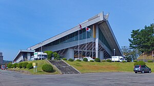
Akita Prefectural Gymnasium
Stadium in Akita, Akita Prefecture, Japan
Distance: Approx. 1515 meters
Latitude and longitude: 39.71944444,140.09386111
Akita Prefectural Gymnasium (秋田県立体育館, Akita Kenritsu Taiikukan) is a stadium in Akita, Akita Prefecture, Japan. The gymnasium was built in 1968. Yoshio Kobayashi and Masatoshi Soh were the architects.

Akita Castle
Distance: Approx. 1447 meters
Latitude and longitude: 39.7403,140.0794
Akita Castle (秋田城, Akita-jō) refers to the ruins of a Nara period fortified settlement located in what is now the city Akita, Akita Prefecture, Japan. It is also sometimes referred to as “Fort Akita”. The name is sometimes used wrongly for Kubota Castle, an Edo period Japanese castle which served as the headquarters or the Satake, daimyō of Kubota Domain that was a domain in the northern part of Dewa Province created by the Tokugawa shogunate.
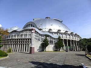
CNA Arena Akita
Arena in Akita, Japan
Distance: Approx. 733 meters
Latitude and longitude: 39.72563889,140.08769444
CNA Arena Akita is an arena in Rinkai-area, Akita, Japan. It is owned and run by the city. Cable Networks Akita acquired its naming rights in 2015.

Akita Sports Plus ASP Stadium
Football stadium in Akita Prefecture, Japan
Distance: Approx. 1817 meters
Latitude and longitude: 39.72155,140.09927778
Akita Sports Plus ASP Stadium (秋田スポーツPLUS ASPスタジアム, Akita Supo-tsu Purasu ASP sutajiamu) for their sponsor the Akita Sports Plus,is a football stadium in Akita, Akita Prefecture, Japan. The stadium has a capacity of 4,992 and has been the home ground of J3 League club Blaublitz Akita since 2013. It was formerly known as Akita Yabase Playing Field.

Cable Networks Akita
Japanese cable provider
Distance: Approx. 1407 meters
Latitude and longitude: 39.71938889,140.09222222
Cable Networks Akita, also known as CNA and in Japanese as Akita Cable Television (秋田ケーブルテレビ), is a cable provider in Japan with 46,418 connected households as of February 27, 2017. The company was established in June 1985 with investments from local companies; however, due to economic constraints, the company remained inactive before starting regular operations. In 1994, due to deregulation in the broadcast and communications sectors, companies like Nissho Iwai and Nippon Telecom (the current SoftBank) injected capital in 1994 and under the leadership of both companies, its service started on December 1, 1997.

Akita Prefectural Skating Rink
Distance: Approx. 173 meters
Latitude and longitude: 39.726,140.07830556
Akita Prefectural Skating Rink (秋田県立スケート場, Akita Kenritsu Sukeitojo) is an indoor speed skating oval located in Akita, Akita, Japan. The first indoor skating rink in Akita Prefecture was located near Prefectural Gymnasium.

Akita Prefectural General Pool
Swimming venue in Akita, Japan
Distance: Approx. 1003 meters
Latitude and longitude: 39.72341667,140.06883333
Akita Prefectural General Pool (秋田県立総合プール, Akita Kenritsu Sōgō Pūru) is a swimming venue in Akita, Akita, Japan. An Olympic competitor, Hiroko Nagasaki is the honorary director. It hosted the 2001 World Games, and it is the largest swimming pool in the prefecture.

Sakigake Yabase Baseball Stadium
Distance: Approx. 1715 meters
Latitude and longitude: 39.71997222,140.09702778
The Sakigake Yabase Baseball Stadium (さきがけ八橋球場, Sakigake Yabase Kyujo) (official name: Akita City Yabase Sports Park Baseball Stadium) is a stadium in Akita, Akita, Japan.

Akita Sakigake Shimpō
Distance: Approx. 1249 meters
Latitude and longitude: 39.71827778,140.08808333
Akita Sakigake Shimpo (秋田魁新報, Akita Sakigake Shimpō) is a Japanese daily newspaper published mainly in Akita prefecture. The company is based in Akita, Akita. The newspaper is dominant in its region, with a market penetration approaching 54 percent of Akita Prefecture households.

Koshiō Shrine
Shrine in Akita, Japan
Distance: Approx. 1040 meters
Latitude and longitude: 39.7362,140.0831
Koshiō Shrine (古四王神社, Koshiō jinja) is a Shinto shrine located in Akita, Akita Prefecture, Japan. It enshrines the kami of Ōhiko no mikoto (大彦命) and Takemikazuchi no mikoto (武甕槌命). Its annual festival takes place on May 8.
Weather in this IP's area
fog
22 Celsius
22 Celsius
22 Celsius
22 Celsius
1010 hPa
100 %
1010 hPa
1010 hPa
3000 meters
1.54 m/s
140 degree
75 %
05:25:18
17:41:06