Country:
 Japan
JapanRegion:
City:
Latitude and Longitude:
Time Zone:
Postal Code:
IP information under different IP Channel
ip-api
Country
Region
City
ASN
Time Zone
ISP
Blacklist
Proxy
Latitude
Longitude
Postal
Route
IPinfo
Country
Region
City
ASN
Time Zone
ISP
Blacklist
Proxy
Latitude
Longitude
Postal
Route
MaxMind
Country
Region
City
ASN
Time Zone
ISP
Blacklist
Proxy
Latitude
Longitude
Postal
Route
Luminati
Country
JPRegion
05
City
akita
ASN
Time Zone
Asia/Tokyo
ISP
Cable Networks Akita Co.,ltd.
Latitude
Longitude
Postal
db-ip
Country
Region
City
ASN
Time Zone
ISP
Blacklist
Proxy
Latitude
Longitude
Postal
Route
ipdata
Country
Region
City
ASN
Time Zone
ISP
Blacklist
Proxy
Latitude
Longitude
Postal
Route
Popular places and events near this IP address
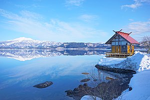
Akita Prefecture
Prefecture of Japan
Distance: Approx. 760 meters
Latitude and longitude: 39.71861111,140.1025
Akita Prefecture (秋田県, Akita-ken) [a̠kʲita̠] is a prefecture of Japan located in the Tōhoku region of Honshu. Its population is estimated 915,691 (as of 1 August 2023) and its geographic area is 11,637 km2 (4,493 sq mi). Akita Prefecture is bordered by Aomori Prefecture to the north, Iwate Prefecture to the east, Miyagi Prefecture to the southeast, and Yamagata Prefecture to the south.

Akita (city)
Core city in Tōhoku, Japan
Distance: Approx. 857 meters
Latitude and longitude: 39.72002778,140.10258333
Akita (Japanese: 秋田市, Hepburn: Akita-shi) IPA: [aꜜki̥ta]; lit."Autumn field City" is the capital city of Akita Prefecture, Japan, and has been designated a core city since 1 April 1997. As of 1 August 2023, the city has an estimated population of 300,502 persons in 136,628 households and a population density of 332 persons per km². The total area of the city is 906.07 square kilometres (349.84 sq mi).
Blaublitz Akita
Association football club
Distance: Approx. 1024 meters
Latitude and longitude: 39.71922222,140.10558333
Blaublitz Akita (ブラウブリッツ秋田, Burauburittsu Akita) is a Japanese professional association football team based in Akita, capital of Akita Prefecture. The club currently play in the J2 League, Japanese second tier of professional football league. Due to the club's former ownership by TDK and thus formerly known as the TDK S.C. (JaWiki), most of the players were employees of TDK's Akita factory.
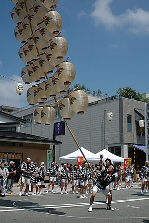
Akita Kantō
Distance: Approx. 1612 meters
Latitude and longitude: 39.71847222,140.11319444
The Akita Kantō (秋田竿燈まつり) is a Japanese festival celebrated from 3–7 August in Akita City, Akita Prefecture in hope for a good harvest. Around two hundred bamboo poles five to twelve metres long, bearing twenty-four or forty-six lanterns, topped with gohei, and weighing up to fifty kilograms, are carried through the streets by night on the palms, foreheads, shoulders, or lower backs of the celebrants. The festival is first referred to in a travel diary of 1789 The Road Where the Snow Falls (雪の降る道).
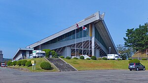
Akita Prefectural Gymnasium
Stadium in Akita, Akita Prefecture, Japan
Distance: Approx. 492 meters
Latitude and longitude: 39.71944444,140.09386111
Akita Prefectural Gymnasium (秋田県立体育館, Akita Kenritsu Taiikukan) is a stadium in Akita, Akita Prefecture, Japan. The gymnasium was built in 1968. Yoshio Kobayashi and Masatoshi Soh were the architects.
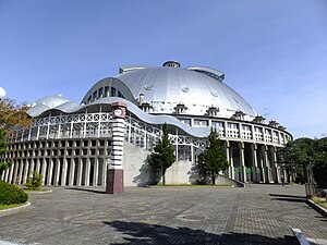
CNA Arena Akita
Arena in Akita, Japan
Distance: Approx. 1325 meters
Latitude and longitude: 39.72563889,140.08769444
CNA Arena Akita is an arena in Rinkai-area, Akita, Japan. It is owned and run by the city. Cable Networks Akita acquired its naming rights in 2015.

Akita Sports Plus ASP Stadium
Football stadium in Akita Prefecture, Japan
Distance: Approx. 810 meters
Latitude and longitude: 39.72155,140.09927778
Akita Sports Plus ASP Stadium (秋田スポーツPLUS ASPスタジアム, Akita Supo-tsu Purasu ASP sutajiamu) for their sponsor the Akita Sports Plus,is a football stadium in Akita, Akita Prefecture, Japan. The stadium has a capacity of 4,992 and has been the home ground of J3 League club Blaublitz Akita since 2013. It was formerly known as Akita Yabase Playing Field.

Cable Networks Akita
Japanese cable provider
Distance: Approx. 529 meters
Latitude and longitude: 39.71938889,140.09222222
Cable Networks Akita, also known as CNA and in Japanese as Akita Cable Television (秋田ケーブルテレビ), is a cable provider in Japan with 46,418 connected households as of February 27, 2017. The company was established in June 1985 with investments from local companies; however, due to economic constraints, the company remained inactive before starting regular operations. In 1994, due to deregulation in the broadcast and communications sectors, companies like Nissho Iwai and Nippon Telecom (the current SoftBank) injected capital in 1994 and under the leadership of both companies, its service started on December 1, 1997.

Sakigake Yabase Baseball Stadium
Distance: Approx. 572 meters
Latitude and longitude: 39.71997222,140.09702778
The Sakigake Yabase Baseball Stadium (さきがけ八橋球場, Sakigake Yabase Kyujo) (official name: Akita City Yabase Sports Park Baseball Stadium) is a stadium in Akita, Akita, Japan.

Akita Sakigake Shimpō
Distance: Approx. 682 meters
Latitude and longitude: 39.71827778,140.08808333
Akita Sakigake Shimpo (秋田魁新報, Akita Sakigake Shimpō) is a Japanese daily newspaper published mainly in Akita prefecture. The company is based in Akita, Akita. The newspaper is dominant in its region, with a market penetration approaching 54 percent of Akita Prefecture households.

Akita Bank Red Arrows
Basketball team
Distance: Approx. 1606 meters
Latitude and longitude: 39.72358333,140.11005556
Akita Bank Red Arrows is a Japanese women's basketball club based in Akita, Akita, playing in the Japan Industrial and Commercial Basketball Federation. They play their home games at the Akita Prefectural Gymnasium, located on the Yabase Sports Park.
Akita City Culture Hall
Concert Hall in Akita, Japan
Distance: Approx. 464 meters
Latitude and longitude: 39.7185,140.09802778
The Akita City Culture Hall (秋田市文化会館, Akitashi Bunka Kaikan) is a multi-purpose public cultural facility in Akita, Japan. It hosted the 2001 World Games for powerlifting and bodybuilding. The main concert hall has a seating capacity of 1,188.
Weather in this IP's area
fog
22 Celsius
22 Celsius
22 Celsius
22 Celsius
1010 hPa
100 %
1010 hPa
1010 hPa
3000 meters
1.54 m/s
140 degree
75 %
05:25:14
17:41:03