Country:
 New Zealand
Region:
City:
Latitude and Longitude:
Time Zone:
Postal Code:
IP information under different IP Channel
ip-api
Country
Region
City
ASN
Time Zone
ISP
Blacklist
Proxy
Latitude
Longitude
Postal
Route
IPinfo
Country
Region
City
ASN
Time Zone
ISP
Blacklist
Proxy
Latitude
Longitude
Postal
Route
MaxMind
Country
Region
City
ASN
Time Zone
ISP
Blacklist
Proxy
Latitude
Longitude
Postal
Route
Luminati
Country
NZRegion
can
City
christchurch
ASN
Time Zone
Pacific/Auckland
ISP
CELLO GROUP LIMITED
Latitude
Longitude
Postal
db-ip
Country
Region
City
ASN
Time Zone
ISP
Blacklist
Proxy
Latitude
Longitude
Postal
Route
ipdata
Country
Region
City
ASN
Time Zone
ISP
Blacklist
Proxy
Latitude
Longitude
Postal
Route
Popular places and events near this IP address

Addington, New Zealand
Suburb of Christchurch, New Zealand
Distance: Approx. 931 meters
Latitude and longitude: -43.545,172.609
Addington is a major suburb of Christchurch, New Zealand. It is sited 2.5 kilometres (1.6 mi) south-west of the city centre. As an inner city suburb, Addington has a mix of residential, retail and light industrial properties.

Addington Railway Workshops
Distance: Approx. 623 meters
Latitude and longitude: -43.5395,172.6077
The Addington Railway Workshops was a major railway workshops established in the Christchurch suburb of Addington in 1877 by the Public Works Department, and transferred in 1880 to the newly formed New Zealand Railways Department (NZR). The workshops closed in 1990.

Christchurch West High School
New Zealand school (1858–1966)
Distance: Approx. 675 meters
Latitude and longitude: -43.53756667,172.62345278
Christchurch West High School (originally Christchurch Academy then High School of Christchurch and then West Christchurch Borough School) existed prior to 1966 on the site of Hagley College in Hagley Avenue, in Christchurch, New Zealand. In that year 'West' amalgamated with Technical High School to become Hagley High School. As part of that amalgamation, the maroon, black and white colours were changed to teal.

Court Theatre (New Zealand)
New Zealand theatre in Christchurch
Distance: Approx. 541 meters
Latitude and longitude: -43.54136,172.61039
The Court Theatre is a professional theatre company based in Christchurch, New Zealand. It was founded in 1971 and located in the Christchurch Arts Centre from 1976 until the February 2011 Christchurch earthquake. It opened new premises in Addington in December 2011.
Hagley College
State co-ed secondary (years 9–15) school
Distance: Approx. 670 meters
Latitude and longitude: -43.5377,172.6234
Hagley College (previously Hagley Community College and Hagley High School), is a state secondary school in inner-city Christchurch, New Zealand. Prior to 1966 the school was Christchurch West High School, which was founded in 1858.

Christchurch railway station, New Zealand
Railway station in New Zealand
Distance: Approx. 624 meters
Latitude and longitude: -43.53992778,172.60789167
Christchurch railway station is in the Canterbury region of New Zealand's South Island. It is on the Main North Line at Addington junction, and is the only remaining passenger railway station in the city: suburban passenger trains were cancelled due to lack of demand in the 1970s. It is the terminus of the South Island's two remaining long-distance passenger trains, the Coastal Pacific to Picton and the TranzAlpine to Greymouth.
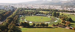
Hagley Oval
New Zealand cricket ground
Distance: Approx. 536 meters
Latitude and longitude: -43.534,172.619
Hagley Oval is a cricket ground in Hagley Park in the central city of Christchurch, New Zealand. The first recorded match on the ground was in 1867, when Canterbury cricket team hosted Otago cricket team. Canterbury used the ground infrequently from then through until the 1920s, but hardly stopped during World War I. The first match in the Plunket Shield was played there in December 1907, when Canterbury played Auckland.

Christchurch Hospital
Hospital in Christchurch, New Zealand
Distance: Approx. 925 meters
Latitude and longitude: -43.5344,172.6255
Christchurch Hospital is the largest tertiary hospital in the South Island of New Zealand. The public hospital is in the centre of Christchurch city, on the edge of Hagley Park, and serves the wider Canterbury region. The Canterbury District Health Board (CDHB) operates the hospital with funding from the government.

Canterbury Cricket Umpires' Association Pavilion
Pavilion in Christchurch, New Zealand
Distance: Approx. 593 meters
Latitude and longitude: -43.53399444,172.62008889
The Canterbury Cricket Umpires' Association Pavilion in Christchurch, New Zealand, is a historic cricket pavilion. Built in 1864, it was registered by Heritage New Zealand as a Category II historic place on 11 December 2003. It forms part of Hagley Oval.

Nurses' Memorial Chapel
Church in Christchurch, New Zealand
Distance: Approx. 849 meters
Latitude and longitude: -43.53419,172.62429
The Nurses' Memorial Chapel at Christchurch Hospital, New Zealand, is registered as a Category I heritage building.
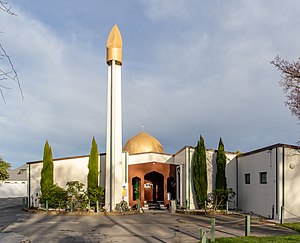
Al Noor Mosque, Christchurch
Mosque in Christchurch, New Zealand
Distance: Approx. 615 meters
Latitude and longitude: -43.53294444,172.61172222
The Al Noor Mosque (Arabic: مسجد النور, Masjid al-Noor) is a Sunni mosque in the Christchurch suburb of Riccarton in New Zealand. It was built between 1983 and 1985 by the Muslim Association of Canterbury, an organisation founded in 1977 that also manages the mosque building. It was the primary target of the Christchurch mosque shootings of 15 March 2019.

Bandsmen's Memorial Rotunda
War memorial bandstand in Hagley Park, Christchurch
Distance: Approx. 805 meters
Latitude and longitude: -43.53263889,172.62194444
The Bandsmen's Memorial Rotunda is a memorial bandstand in Hagley Park, Christchurch. Built in 1926 to commemorate armed forces bandsmen that died during World War I, the rotunda is on the south-side of the Avon River / Ōtākaro, opposite the Christchurch Botanic Gardens and close to Christchurch Hospital.
Weather in this IP's area
broken clouds
10 Celsius
10 Celsius
9 Celsius
12 Celsius
1025 hPa
84 %
1025 hPa
1023 hPa
10000 meters
2.57 m/s
60 degree
75 %
06:31:13
19:57:31