Country:
 Thailand
Region:
City:
Latitude and Longitude:
Time Zone:
Postal Code:
IP information under different IP Channel
ip-api
Country
Region
City
ASN
Time Zone
ISP
Blacklist
Proxy
Latitude
Longitude
Postal
Route
IPinfo
Country
Region
City
ASN
Time Zone
ISP
Blacklist
Proxy
Latitude
Longitude
Postal
Route
MaxMind
Country
Region
City
ASN
Time Zone
ISP
Blacklist
Proxy
Latitude
Longitude
Postal
Route
Luminati
Country
THRegion
10
City
bangkok
ASN
Time Zone
Asia/Bangkok
ISP
JasTel Network
Latitude
Longitude
Postal
db-ip
Country
Region
City
ASN
Time Zone
ISP
Blacklist
Proxy
Latitude
Longitude
Postal
Route
ipdata
Country
Region
City
ASN
Time Zone
ISP
Blacklist
Proxy
Latitude
Longitude
Postal
Route
Popular places and events near this IP address
Bang Phlat district
Khet in Bangkok, Thailand
Distance: Approx. 847 meters
Latitude and longitude: 13.79388889,100.505
Bang Phlat (Thai: บางพลัด, pronounced [bāːŋ pʰlát]) is one of the 50 districts (khet) of Bangkok, Thailand. Its neighboring districts, clockwise from the north, are Bang Kruai district, Bang Sue, Dusit, Phra Nakhon, Bangkok Noi, and Taling Chan.

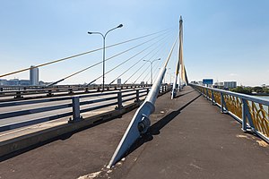
Krung Thon Bridge
Bridge in Bangkok, Thailand
Distance: Approx. 667 meters
Latitude and longitude: 13.780892,100.502951
Krung Thon Bridge (Thai: สะพานกรุงธน, RTGS: Saphan Krung Thon, pronounced [sā.pʰāːn krūŋ tʰōn]) is a bridge over the Chao Phraya River in Bangkok, in Thailand, connecting the districts Dusit and Bang Phlat. The bridge has 6 spans, and consists of a steel superstructure resting on concrete piers.
Faculty of Medicine Vajira Hospital, Navamindradhiraj University
Distance: Approx. 747 meters
Latitude and longitude: 13.78055556,100.50916667
The Faculty of Medicine Vajira Hospital (Thai: คณะแพทยศาสตร์วชิรพยาบาล) is a medical school located in Bangkok, Thailand. The faculty has its origin as a medical college, previously known as BMA Medical College & Vajira Hospital (Thai: วิทยาลัยแพทยศาสตร์กรุงเทพมหานครและวชิรพยาบาล). The school is run in collaboration with Vajira Hospital, Mahidol University and the Bangkok Metropolitan Administration Medical Department.

Vajira Hospital
Hospital in Bangkok , Thailand /
Distance: Approx. 747 meters
Latitude and longitude: 13.78055556,100.50916667
Vajira Hospital (Thai: วชิรพยาบาล, RTGS: Wachiraphayaban) is one of the first hospitals in Thailand, founded by King Rama VI. It is a teaching university hospital of the Faculty of Medicine Vajira Hospital, Navamindradhiraj University; the Faculty of Medicine, Bangkokthonburi University and an affiliated teaching hospital of the Faculty of Medicine, Srinakharinwirot University. It is situated on Samsen Road, Dusit District, Bangkok, Thailand.
Navamindradhiraj University
University in Thailand
Distance: Approx. 747 meters
Latitude and longitude: 13.78055556,100.50916667
Navamindradhiraj University (NMU) (Thai: มหาวิทยาลัยนวมินทราธิราช; RTGS: Mahawitthayalai Nawaminthrathirat), formerly University of Bangkok Metropolis (Thai: มหาวิทยาลัยกรุงเทพมหานคร; RTGS: Mahawitthayalai Krung Thep Maha Nakhon), is a public university located in Bangkok, Thailand. The university focuses on medical science and public services such as medicine.
Nakornping Hospital
Hospital in Chiang Mai , Thailand
Distance: Approx. 747 meters
Latitude and longitude: 13.78055556,100.50916667
Nakornping Hospital (Thai: โรงพยาบาลนครพิงค์) is a hospital located in Chiang Mai, Thailand. It is the second largest hospital in Chiang Mai with an in-patient capacity of 742 beds as of 2022. It is now serving as the regional hospital of Chiang Mai province.

Samsen Road
Road and neighbourhood in Bangkok, Thailand
Distance: Approx. 773 meters
Latitude and longitude: 13.78344722,100.51211944
Samsen or spelled Sam Sen (Thai: สามเสน, pronounced [sǎːm.sěːn]) is a road and neighbourhood in Bangkok considered to be one of Bangkok's oldest. Samsen road starts from Bang Lamphu intersection in the area of Bang Lamphu within Phra Nakhon district and wends northeast to Dusit district as far as it ends at Kiakkai intersection, covering 4.6 km (2.8 mi). It runs parallel to east Chao Phraya river all the route.

Wachiraphayaban subdistrict
Khwaeng in Thailand
Distance: Approx. 669 meters
Latitude and longitude: 13.78055556,100.50377778
Wachiraphayaban (Thai: วชิรพยาบาล) is a khwaeng (subdistrict) of Dusit District, in Bangkok, Thailand.
Sukhothai Palace
Thai royal residence in Bangkok
Distance: Approx. 694 meters
Latitude and longitude: 13.7815,100.5097
Sukhothai Palace or Sukhodaya Palace (Thai: วังศุโขทัย; RTGS: Wang Sukhothai) is a royal residence situated on Samsen Road in Dusit District, Bangkok, Thailand. It is nearby to Dusit Palace and Vajira Hospital. The palace was the residence of King Prajadhipok (King Rama VII) and King Vajiralongkorn (King Rama X) before they ascended to the throne.

Nakhon Chai Si Road
Road in Bangkok, Thailand
Distance: Approx. 692 meters
Latitude and longitude: 13.78527778,100.51191667
Nakhon Chai Si Road (Thai: ถนนนครไชยศรี; pronounced [tʰā.nǒn ná(ʔ).kʰɔ̄ːn t͡ɕʰāj sǐː]) is a road in Bangkok. Its name is origin of Thanon Nakhon Chai Si subdistrict of Dusit district, since it runs through the area. It starts from Rama VI road, passing Rama V, Pichai, Nakhon Ratchasima, Samsen roads, then cuts across Si Yan intersection, as far as ends at the Chao Phraya river at the Payap pier.

Bang Phlat MRT station
Monorail station in Bangkok, Thailand
Distance: Approx. 694 meters
Latitude and longitude: 13.7925,100.5049
Bang Phlat station (Thai: สถานีบางพลัด, pronounced [sā.tʰǎː.nīː bāːŋ pʰlát]), is an elevated railway station on MRT Blue Line in Bangkok, in Thailand. The station opened on 4 December 2019. The station is one of the nine stations of phase 3 of MRT Blue Line.

Si Yan, Bangkok
Neighbourhood in Bangkok
Distance: Approx. 677 meters
Latitude and longitude: 13.78535833,100.51178611
Si Yan or Sri Yan (Thai: ศรีย่าน, pronounced [sǐː jâːn]) is a neighbourhood in Thanon Nakhon Chai Si Subdistrict, Dusit District, Bangkok. It roughly occupies the four-way intersection of the same name. The area famous for its market and restaurants with street food.
Weather in this IP's area
scattered clouds
33 Celsius
40 Celsius
32 Celsius
33 Celsius
1005 hPa
79 %
1005 hPa
1005 hPa
10000 meters
7.72 m/s
13.89 m/s
260 degree
40 %
06:06:51
18:24:50