Country:
Region:
City:
Latitude and Longitude:
Time Zone:
Postal Code:
IP information under different IP Channel
ip-api
Country
Region
City
ASN
Time Zone
ISP
Blacklist
Proxy
Latitude
Longitude
Postal
Route
Luminati
Country
Region
u
City
letterkenny
ASN
Time Zone
Europe/Dublin
ISP
Societe Internationale de Telecommunications Aeronautiques
Latitude
Longitude
Postal
IPinfo
Country
Region
City
ASN
Time Zone
ISP
Blacklist
Proxy
Latitude
Longitude
Postal
Route
db-ip
Country
Region
City
ASN
Time Zone
ISP
Blacklist
Proxy
Latitude
Longitude
Postal
Route
ipdata
Country
Region
City
ASN
Time Zone
ISP
Blacklist
Proxy
Latitude
Longitude
Postal
Route
Popular places and events near this IP address

St Eunan's College
Secondary school in Ireland
Distance: Approx. 1243 meters
Latitude and longitude: 54.951737,-7.745554
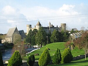
St Eunan's College ( YOO-nən; Irish: Coláiste Adhamhnáin), known locally as The College to distinguish it from the cathedral and GAA club, is a voluntary Roman Catholic all-male, English-medium secondary day school (and former boarding school) in County Donegal, Ireland. It is located upon Sentry Hill in Letterkenny. Named after Adomnán or Eunan (the Abbot of Iona who was native to Tír Chonaill, mainly modern County Donegal, and is patron saint of the Roman Catholic Diocese of Raphoe), the school's foundation stone was laid on the patron saint's feast day of 23 September.

Cathedral of St Eunan and St Columba
Church in County Donegal, Ireland
Distance: Approx. 863 meters
Latitude and longitude: 54.95027778,-7.74
St Eunan's Cathedral ( YOO-nən), or the Cathedral of St Eunan and St Columba as it is also known, is a cathedral in the parish of Conwal and Leck, part of the Diocese of Raphoe. Built between the years of 1890 and 1900, the cathedral is found in Letterkenny, County Donegal in Ireland. There are two cathedrals in the county; an older cathedral of the same name is found in the town of Raphoe, and since the Reformation, has been used by the Church of Ireland.

Letterkenny University Hospital
Hospital in County Donegal, Ireland
Distance: Approx. 1293 meters
Latitude and longitude: 54.956542,-7.725474
Letterkenny University Hospital (Irish: Ospidéal na hOllscoile Leitir Ceanainn) is a general hospital at Letterkenny, County Donegal, Ireland. One of Ireland's busiest, the campus is divided by a main road heading on towards the North/West of Donegal on the N56 road (Ireland). A teaching hospital, it maintains links with the University of Galway, ATU Letterkenny and the Royal College of Surgeons.
Leckview Park
Distance: Approx. 261 meters
Latitude and longitude: 54.944,-7.7333
Leckview Park (Irish: Páirc Radharc Leac) is a football stadium in County Donegal, Ireland. Located on the banks of the River Swilly on Canal Street close to central Letterkenny, it is the home ground of Letterkenny Rovers. It is also close to the county's largest multi-screen cinema complex at Leckview Lane on Letterkenny's Pearse Road.

Donegal County Museum
County museum in County Donegal, Ireland
Distance: Approx. 1096 meters
Latitude and longitude: 54.9546,-7.7349
Donegal County Museum (Irish: Músaem Chontae Dhún na nGall) is a county museum in County Donegal in Ireland. Located on the High Road in Letterkenny, the museum building was completed in 1843 as the Warden's House of the Letterkenny Workhouse. The building was repurposed as a museum in the late 20th century.

An Grianán Theatre
Theatre in County Donegal, Republic of Ireland
Distance: Approx. 880 meters
Latitude and longitude: 54.95305556,-7.73138889
An Grianán Theatre (Irish: Amharclann an Ghrianáin) is the largest theatre in County Donegal. Located in Letterkenny's Port Road district, its current director is Patricia McBride. With a seating capacity of 383, the theatre provides a range of programming including drama, comedy, music, pantomime, and family shows as well as workshops and classes.

Courtyard Shopping Centre
Retail facility in Letterkenny, County Donegal, Ireland
Distance: Approx. 625 meters
Latitude and longitude: 54.949,-7.737
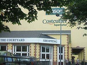
The Courtyard Shopping Centre is a retail complex in central Letterkenny, County Donegal, Ireland.
Letterkenny Regional Sports and Leisure Complex
Distance: Approx. 1379 meters
Latitude and longitude: 54.945484,-7.751369
Letterkenny Regional Sports and Leisure Complex is a sports complex located in Letterkenny, County Donegal, Ireland. Located near O'Donnell Park, RTÉ Television has broadcast live from the venue on several occasions.

Conwal Parish Church (Church of Ireland)
Distance: Approx. 865 meters
Latitude and longitude: 54.95107,-7.73867
Conwal Parish Church is a Church of Ireland church located in Letterkenny, County Donegal, Ireland. It is located opposite the Cathedral of St Eunan and St Columba at the top of Church Street. The church dates back to the 17th century.

Oldtown, Letterkenny
Townland in Ulster, Ireland
Distance: Approx. 1404 meters
Latitude and longitude: 54.9566,-7.7204
Oldtown (Irish: An Seanbhaile) is a townland within the town of Letterkenny, County Donegal, Ireland. It is located in the parish of Conwal and Leck to the south of the River Swilly. As its name suggests, it is the oldest part of Letterkenny—being older than Letterkenny itself—and was the starting point of the area's development.

Main Street, Letterkenny
Thoroughfare in Letterkenny, County Donegal, Ireland
Distance: Approx. 728 meters
Latitude and longitude: 54.950157,-7.73722
Main Street (Irish: An Phríomhshráid) is an important thoroughfare in Letterkenny, County Donegal, Ireland. Sometimes claimed to be the longest street in Ireland, it is divided into two sections, with Lower Main Street (the south end) running from the junction at Oldtown Road to the Market Square and Upper Main Street (the north end) running from the Market Square to the junction at Crossview House. Traffic flows in a one-way system from Crossview House southwards.

R940 road (Ireland)
Regional road in Ireland
Distance: Approx. 1085 meters
Latitude and longitude: 54.953447,-7.720742
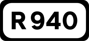
The R940 road is a short regional road in Ireland, located in Letterkenny, County Donegal.
Weather in this IP's area
overcast clouds
13 Celsius
13 Celsius
13 Celsius
13 Celsius
1018 hPa
94 %
1018 hPa
1017 hPa
10000 meters
4.02 m/s
10.93 m/s
160 degree
98 %
07:43:13
16:45:49