Country:
 Canada
Region:
City:
Latitude and Longitude:
Time Zone:
Postal Code:
IP information under different IP Channel
ip-api
Country
Region
City
ASN
Time Zone
ISP
Blacklist
Proxy
Latitude
Longitude
Postal
Route
IPinfo
Country
Region
City
ASN
Time Zone
ISP
Blacklist
Proxy
Latitude
Longitude
Postal
Route
MaxMind
Country
Region
City
ASN
Time Zone
ISP
Blacklist
Proxy
Latitude
Longitude
Postal
Route
Luminati
Country
CARegion
qc
City
lacmegantic
ASN
Time Zone
America/Toronto
ISP
CC-3272
Latitude
Longitude
Postal
db-ip
Country
Region
City
ASN
Time Zone
ISP
Blacklist
Proxy
Latitude
Longitude
Postal
Route
ipdata
Country
Region
City
ASN
Time Zone
ISP
Blacklist
Proxy
Latitude
Longitude
Postal
Route
Popular places and events near this IP address

Le Granit Regional County Municipality
Regional county municipality in Quebec, Canada
Distance: Approx. 650 meters
Latitude and longitude: 45.58333333,-70.88333333
Le Granit (Granite) is a regional county municipality in the Estrie region of eastern Quebec, Canada. Located directly south of Quebec City, it borders the region of Chaudière-Appalaches, as well as the US states of New Hampshire and Maine. It is named for its abundance of granite.
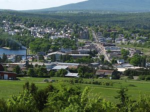
Lac-Mégantic, Quebec
Town in Quebec, Canada
Distance: Approx. 650 meters
Latitude and longitude: 45.58333333,-70.88333333
Lac-Mégantic (French pronunciation: [lak meɡɑ̃tik]) is a town in the Estrie region of Quebec, Canada. It is located on Lac Mégantic, a freshwater lake after which the town was named. Situated in the former Frontenac County in the historic Eastern Townships, Lac-Mégantic is the seat of Le Granit Regional County Municipality and of the judicial district of Mégantic.

Frontenac, Quebec
Municipality in Quebec, Canada
Distance: Approx. 3524 meters
Latitude and longitude: 45.58,-70.83
Frontenac is a municipality in Le Granit Regional County Municipality in Estrie, Quebec, Canada, on the Canada–United States border. Its population was 1,650 as of the Canada 2011 Census.

Lake Mégantic
Glacial lake in Quebec, Canada
Distance: Approx. 7628 meters
Latitude and longitude: 45.51388889,-70.87722222
Lake Mégantic (French: Lac Mégantic, French pronunciation: [lak meɡɑ̃tik]) is a body of water in Québec, located in the Appalachian Mountains near the U.S. border. It is a source of the Chaudière River which drains into the St Lawrence River at Québec City. The lake has a surface area of 26.4 km2 (10.2 sq mi) with several villages and small towns on its shores, including Lac-Mégantic, Frontenac, Marston, and Piopolis.
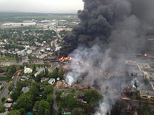
Lac-Mégantic rail disaster
2013 oil train crash in Québec, Canada
Distance: Approx. 927 meters
Latitude and longitude: 45.57777778,-70.885
The Lac-Mégantic rail disaster occurred in the town of Lac-Mégantic, Quebec, Canada, on July 6, 2013, at approximately 1:14 a.m. EDT, when an unattended 73-car Montreal, Maine and Atlantic Railway (MMA) freight train carrying Bakken Formation crude oil rolled down a 1.2% grade from Nantes and derailed downtown, resulting in the explosion and fire of multiple tank cars. Forty-seven people were killed.
Frontenac County, Quebec
Former county of Quebec, Canada
Distance: Approx. 3256 meters
Latitude and longitude: 45.58333333,-70.83333333
Frontenac County was a county of Quebec, Canada. It existed between 1912 and the early 1980s. The territory it covered is today divided into the regional county municipalities of Le Granit in the administrative regions of the Estrie and Beauce-Sartigan in Chaudière-Appalaches.

Glen River (Chaudière River tributary)
River in Estrie, Quebec (Canada)
Distance: Approx. 4579 meters
Latitude and longitude: 45.62139,-70.85638
The Glen River (in French: rivière Glen) is a tributary of the west bank of the Chaudière River which flows north to empty onto the south bank of the St. Lawrence River. The Glen River flows through the municipalities of Nantes and Sainte-Cécile-de-Whitton, in the Le Granit Regional County Municipality, in the administrative region of Estrie, in Quebec, in Canada.

Lac de l'Orignal
Lake in Estrie, Quebec (Canada)
Distance: Approx. 4164 meters
Latitude and longitude: 45.610833,-70.90984
The Lac de l'Orignal (in English: Moose Lake) is a lake located on the territory of the village of Nantes, near Lac-Mégantic in Estrie, in Quebec, in Canada. The lake is crossed by the Glen River which joins the Chaudière River and is a sub-tributary of the St. Lawrence River.

Lac du Rat Musqué
Lake in Estrie, Quebec (Canada)
Distance: Approx. 4164 meters
Latitude and longitude: 45.610833,-70.90984
The Lac du Rat Musqué is a lake located between the municipalities of Sainte-Cécile-de-Whitton and Lac-Drolet, Le Granit Regional County Municipality, in Estrie, in Quebec, in Canada. It is the source of the Madisson River, a tributary of the Chaudière River and a sub-tributary of the St. Lawrence River.

Victoria River (lake Mégantic)
River in Estrie, Quebec (Canada)
Distance: Approx. 6310 meters
Latitude and longitude: 45.539944,-70.928746
The Victoria River (in French: rivière Victoria) is a tributary of the Chaudière River, therefore a sub-tributary of the St. Lawrence River. The Victoria River flows through the municipalities of Val-Racine, Piopolis and Marston, in the Le Granit Regional County Municipality, in the administrative region of Estrie, in Quebec, in Canada.

Nebnellis River
River in Estrie, Quebec (Canada)
Distance: Approx. 7287 meters
Latitude and longitude: 45.63667,-70.82278
The Nebnellis river (in French: rivière Nebnellis) is a tributary of the south-eastern shore of the Chaudière River which flows northward to empty onto the south shore of the St. Lawrence River.

Kokombis River
River in Estrie, Quebec (Canada)
Distance: Approx. 6130 meters
Latitude and longitude: 45.61306,-70.80972
The Kokombis river (in French: rivière Kokombis) is a tributary of the east bank of the Nebnellis River which empties on the south-eastern bank of the Chaudière River; the latter flows northward to empty on the south shore of the St. Lawrence River. The Kokombis River flows through the municipalities of Audet and Frontenac, in the Le Granit Regional County Municipality, in the administrative region of Estrie, in Quebec, in Canada.
Weather in this IP's area
clear sky
8 Celsius
7 Celsius
8 Celsius
8 Celsius
1033 hPa
84 %
1033 hPa
983 hPa
10000 meters
1.56 m/s
1.51 m/s
241 degree
07:04:18
17:52:29