Country:
 Canada
Region:
City:
Latitude and Longitude:
Time Zone:
Postal Code:
IP information under different IP Channel
ip-api
Country
Region
City
ASN
Time Zone
ISP
Blacklist
Proxy
Latitude
Longitude
Postal
Route
IPinfo
Country
Region
City
ASN
Time Zone
ISP
Blacklist
Proxy
Latitude
Longitude
Postal
Route
MaxMind
Country
Region
City
ASN
Time Zone
ISP
Blacklist
Proxy
Latitude
Longitude
Postal
Route
Luminati
Country
CARegion
qc
City
laurierville
ASN
Time Zone
America/Toronto
ISP
CC-3272
Latitude
Longitude
Postal
db-ip
Country
Region
City
ASN
Time Zone
ISP
Blacklist
Proxy
Latitude
Longitude
Postal
Route
ipdata
Country
Region
City
ASN
Time Zone
ISP
Blacklist
Proxy
Latitude
Longitude
Postal
Route
Popular places and events near this IP address

Rivière-du-Nord (electoral district)
Federal electoral district in Quebec, Canada
Distance: Approx. 9901 meters
Latitude and longitude: 45.852,-73.975
Rivière-du-Nord is a federal electoral district in Quebec, Canada, that has been represented in the House of Commons of Canada since 2004.

Les Pays-d'en-Haut Regional County Municipality
Regional county municipality in Quebec, Canada
Distance: Approx. 9421 meters
Latitude and longitude: 45.95,-74.13333333
Les Pays-d'En-Haut (French pronunciation: [le pɛi dɑ̃ o]) is a regional county municipality in the Laurentides region of Quebec, Canada. The population according to the 2016 Canadian Census was 41,877.
CIME-FM
Radio station in Saint-Jérôme, Quebec
Distance: Approx. 8153 meters
Latitude and longitude: 45.86388889,-74.02138889
CIME-FM is a French-language Canadian radio station located in Saint-Jérôme, Quebec, about 40 kilometres (25 mi) north of Montreal. Owned and operated by Cogeco, it broadcasts on 103.9 MHz using a directional antenna with an average effective radiated power of 11,700 watts and a peak effective radiated power of 39,300 watts (class C1). The station has an adult top 40 format under the CIME branding.

Prévost, Quebec
City in Quebec, Canada
Distance: Approx. 9073 meters
Latitude and longitude: 45.87,-74.08
Prévost is a town within the La Rivière-du-Nord Regional County Municipality, Quebec, Canada, and the administrative region of Laurentides in the Laurentian Mountains, north of Montreal. It was created in 1973 from the amalgamation of the former villages of Shawbridge and Lesage with old Prévost on the other side of the Rivière du Nord. Shawbridge was named after William Shaw (1805-1894) who settled in the township of Abercromby in 1847 and built the first bridge over the Rivière du Nord.

Piedmont, Quebec
Municipality in Quebec, Canada
Distance: Approx. 9941 meters
Latitude and longitude: 45.9,-74.13
Piedmont is a small municipality within the Les Pays-d'en-Haut Regional County Municipality, Quebec, Canada, in the Laurentian Mountains of the administrative region of Laurentides. It is located along the North River and Autoroute 15 and Route 117, north of Montreal. Police services are provided by the Régie intermunicipale de police de la Rivière-du-Nord, which also serves Prévost and some other nearby communities in the Laurentians.
Rivière-du-Nord Intermunicipal Police Board
Canadian intermunicipal policing board
Distance: Approx. 8657 meters
Latitude and longitude: 45.8743,-74.0794
The Régie intermunicipale de police de la Rivière-du-Nord (French for Rivière-du-Nord Intermunicipal Police Board) was the shared police service of three (originally four) municipalities in Quebec's Laurentians: Saint-Hippolyte Piedmont Sainte-Anne-des-Lacs Prévost was originally part of the police service, but left it on April 1, 2004, however the police service's headquarters remained in Prévost. In May 2009 plans were revealed to close the service and turn policing of the remaining three municipalities over to the Sûreté du Québec. On October 23, 2009, the Régie intermunicipale de police de la Rivière-du-Nord's policing operations ended at 1 minute past midnight.

Saint-Hippolyte, Quebec
Municipality in Quebec, Canada
Distance: Approx. 936 meters
Latitude and longitude: 45.93,-74.02
Saint-Hippolyte (historically Saint-Hippolyte-de-Kilkenny) is a municipality within La Rivière-du-Nord Regional County Municipality in the Laurentides region of Quebec, Canada, in the Laurentian mountains about 45 km north of Montreal. The name comes from Saint Hippolytus. Part of the town was formerly known as Abercrombie-Est.

Sainte-Adèle
City in Quebec, Canada
Distance: Approx. 9166 meters
Latitude and longitude: 45.95,-74.13
Sainte-Adèle (French pronunciation: [sɛ̃t adɛl]) is a municipality in Quebec, Canada, and is part of the Les Pays-d'en-Haut Regional County Municipality. It lies on Route 117 about 70 kilometres (43 mi) north-west of Montreal. Its tourism-based economy centres on its skiing and hotel industry.

Prévost station
Railway station in Quebec, Canada
Distance: Approx. 8623 meters
Latitude and longitude: 45.8727,-74.0754
The Prévost station (formerly known as Shawbridge station) is a former Canadian Pacific railway station in Prévost, Quebec, Canada. It now serves as a café and cultural centre for area residents and users of the Parc Linéaire Le P'tit Train du Nord linear park cycling trail, and is no longer connected to the railway network.
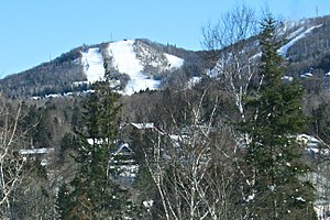
Mont Olympia
Distance: Approx. 8944 meters
Latitude and longitude: 45.9142,-74.1239
Sommet Olympia is a ski school and resort in Quebec, Canada. The resort is located not far from Montreal, in the Laurentians. According to ski express magazine, Mont Olympia is "the best" ski mountain for beginners.
Lac Dodon
Iron meteorite
Distance: Approx. 7606 meters
Latitude and longitude: 45.95,-73.91666667
Lac Dodon is an iron meteorite discovered by Roland Octerneau of Montreal on rural private property near Lac Dodon, Saint-Calixte, Quebec. The recovered fragment measures approximately 10 centimetres (3.9 in) x 5 centimetres (2.0 in) x 6 centimetres (2.4 in). The meteorite was oxidized on its exterior and lying at the surface of the ground.
Weather in this IP's area
clear sky
10 Celsius
9 Celsius
8 Celsius
11 Celsius
1032 hPa
58 %
1032 hPa
1006 hPa
10000 meters
2.2 m/s
2.41 m/s
269 degree
07:17:20
18:04:32