Country:
Region:
City:
Latitude and Longitude:
Time Zone:
Postal Code:
IP information under different IP Channel
ip-api
Country
Region
City
ASN
Time Zone
ISP
Blacklist
Proxy
Latitude
Longitude
Postal
Route
Luminati
Country
Region
02
City
makkah
ASN
Time Zone
Asia/Riyadh
ISP
Mobile Telecommunication Company Saudi Arabia Joint-Stock company
Latitude
Longitude
Postal
IPinfo
Country
Region
City
ASN
Time Zone
ISP
Blacklist
Proxy
Latitude
Longitude
Postal
Route
db-ip
Country
Region
City
ASN
Time Zone
ISP
Blacklist
Proxy
Latitude
Longitude
Postal
Route
ipdata
Country
Region
City
ASN
Time Zone
ISP
Blacklist
Proxy
Latitude
Longitude
Postal
Route
Popular places and events near this IP address

Battle of the Trench
Failed siege of Medina in 627 CE
Distance: Approx. 1059 meters
Latitude and longitude: 24.48333333,39.58333333
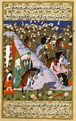
The Battle of the Trench (Arabic: غزوة الخندق, romanized: Ghazwat al-Khandaq), also known as the Battle of Khandaq (Arabic: معركة الخندق, romanized: Ma’rakah al-Khandaq) and the Battle of the Confederates (Arabic: غزوة الاحزاب, romanized: Ghazwat al-Ahzab), was part of the conflict between the Muslims and the Quraysh, where this time the Quraysh took the offensive and advanced on the Muslims, who defended themselves in Medina by digging a trench around their settlement at the suggestion of Salman the Persian. The battle, which took place in 627 and lasted around two weeks, was lightly fought, with the Muslims reported to have suffered five to six casualties and the Quraysh three. The Quraysh, tired of seeing the Islamic prophet Muhammad continue to raid and plunder their trade caravans despite his defeat at the Battle of Uhud, decided to occupy his city base, Medina.

Islamic University of Madinah
University in Madinah, Saudi Arabia
Distance: Approx. 2513 meters
Latitude and longitude: 24.48055556,39.56472222
The Islamic University of Madinah (Arabic: الجامعة الإسلامية بالمدينة المنورة) is a public Islamic university in Medina, Saudi Arabia. Established by King Saud bin Abdulaziz in 1961, the institute is said to have been associated with Salafism, while claiming to have exported Salafi-inclined theologians around the world. Others disagree and state that the institution is objective and scientific, being detached to any singular ideology.

Battle of Uhud
625 battle of the Muslim–Quraysh War
Distance: Approx. 2596 meters
Latitude and longitude: 24.5,39.61
The Battle of Uhud (Arabic: غزوة أحد, romanized: Ghazwat ʾUḥud) was fought between the early Muslims and the Quraysh during the Muslim–Quraysh wars in a valley north of Mount Uhud near Medina on Saturday, 23 March 625 AD (7 Shawwal, 3 AH). After the expulsion of Muslims from Mecca, the former began raiding the caravans of the latter. The conflict came to a head at the Battle of Badr, in which the Meccans were defeated.

Masjid al-Qiblatayn
Mosque in Medina, Saudi Arabia
Distance: Approx. 1171 meters
Latitude and longitude: 24.48408611,39.57890833
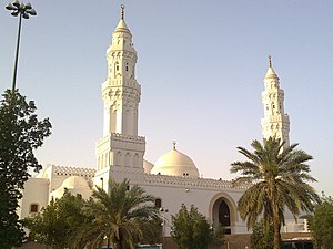
The Masjid al-Qiblatayn (Arabic: مسجد القبلتين, lit. 'Mosque of the Two Qiblas', Hejazi Arabic pronunciation: [mas.dʒɪd al.ɡɪb.la.teːn]), also spelt Masjid al-Qiblatain, is a mosque in Medina believed by Muslims to be the place where the final Islamic prophet, Muhammad, received the command to change the Qibla (direction of prayer) from Jerusalem to Mecca. The mosque was built by Sawad ibn Ghanam ibn Ka'ab during the year 2 AH (623 CE) and is one of the few mosques in the world to have contained two mihrabs (niches indicating the qibla) in different directions. In 1987, during the reign of King Fahd, the mosque was completely torn down and rebuilt.

Battle of Medina (1812)
Battle of the Ottoman–Saudi War
Distance: Approx. 3230 meters
Latitude and longitude: 24.46666667,39.6
The Battle of Medina took place in 1812, Following the Battle of Al-Safra, Tusun's forces began to deal with Saudi forces stationed in Medina.

Sela (Saudi Arabia)
Hill in Saudi Arabia
Distance: Approx. 2404 meters
Latitude and longitude: 24.475,39.59944444
Selaʾ (Arabic: سلع) is a mountain in Medina in modern Saudi Arabia.
Sultanah, Saudi Arabia
Street in Al Madinah Province, Saudi Arabia
Distance: Approx. 858 meters
Latitude and longitude: 24.5,39.58333333
Sultanah is a street with various restaurants and shops in Al Madinah Province, in western Saudi Arabia.
Mosque of Bani Haram
Historic mosque in Medina, Saudi Arabia
Distance: Approx. 2464 meters
Latitude and longitude: 24.47313889,39.59727778
Mosque of Bani Haram (Arabic: مسجد بني حرام) is one of the historic mosques in Medina, Saudi Arabia. It stands in the area where the tribe of Bani Haram lived, and it was used as a base camp during the Battle of the Trench. It is also believed to be the place where the Islamic prophet Muhammad stopped by for prayer during digging of a trench before the battle.
Al-Rayah Mosque
Mosque in Medina, Saudi Arabia
Distance: Approx. 2261 meters
Latitude and longitude: 24.48025,39.60341667
Al-Rayah Mosque (Arabic: مسجد الراية, lit. 'Mosque of the flag'), or Dzubab Mosque, is a mosque located in Medina, Saudi Arabia. The mosque is situated on top of Mount Dzubab (Dzubab means "flies"), and this area is not far from Mount Sala' on the south, Al-'Uyun street on the left hand side, and Az-Zugaibi gas station between Al-'Uyun street and Sulthanah street on the behind. It is narrated that there was a command post (tent/shade) pitched for the Islamic prophet Muhammad in this area at the time of the Battle of the Trench, so it was named as Al-Rayah, which means battle flag.
Bani Harithah Mosque
Mosque in Medina, Saudi Arabia
Distance: Approx. 2435 meters
Latitude and longitude: 24.49188889,39.60972222
Bani Haritsah Mosque (Arabic: مسجد بني حارثة), or Masjid Al-Mustarah, is a mosque located in Medina, Saudi Arabia. It is located at Sayyid asy-Syuhada' street. The naming comes from an account of the Islamic prophet Muhammad taking a rest in this place once, during the way home returning from the Battle of Uhud.

The Seven Mosques
Complex of six historic mosques in Medina, Saudi Arabia
Distance: Approx. 2040 meters
Latitude and longitude: 24.47683333,39.59597222
The Seven Mosques (Arabic: المساجد السبعة, romanized: al-Masājid al-Saʿba) is a complex of six small historic and often visited mosques in the city of Medina, Saudi Arabia. Despite only consisting of six mosques, the complex is called seven because some think it originally consisted of seven mosques. Another reason for the name is that many visitors usually visit Masjid Al-Qiblatayn among these mosques on their visit to Medina, making it seven.
As-Sajadah Mosque
Mosque in Medina, Saudi Arabia
Distance: Approx. 2906 meters
Latitude and longitude: 24.47833333,39.60972222
As-Sajadah Mosque (Arabic: مسجد السجدة), also known as Asy-Syukr Mosque or Abi Dzar Mosque, is a mosque located 900 meters north of Al-Masjid an-Nabawi in Medina, Saudi Arabia. The mosque is called "As-Sajadah" meaning "the prostration" because of an account of the Islamic prophet Muhammad prostrating here after hearing a good news from Gabriel regarding salawat. Today, it is better known as Abi Dzar Mosque because it is on Abi Dzar street.
Weather in this IP's area
broken clouds
34 Celsius
32 Celsius
34 Celsius
34 Celsius
1011 hPa
21 %
1011 hPa
946 hPa
10000 meters
6.69 m/s
210 degree
75 %
06:31:38
17:38:57
