Country:
Region:
City:
Latitude and Longitude:
Time Zone:
Postal Code:
IP information under different IP Channel
ip-api
Country
Region
City
ASN
Time Zone
ISP
Blacklist
Proxy
Latitude
Longitude
Postal
Route
Luminati
Country
Region
mn
City
minneapolis
ASN
Time Zone
America/Chicago
ISP
USINTERNET
Latitude
Longitude
Postal
IPinfo
Country
Region
City
ASN
Time Zone
ISP
Blacklist
Proxy
Latitude
Longitude
Postal
Route
db-ip
Country
Region
City
ASN
Time Zone
ISP
Blacklist
Proxy
Latitude
Longitude
Postal
Route
ipdata
Country
Region
City
ASN
Time Zone
ISP
Blacklist
Proxy
Latitude
Longitude
Postal
Route
Popular places and events near this IP address
Cedar Lake (Minneapolis)
Lake in the state of Minnesota, United States
Distance: Approx. 297 meters
Latitude and longitude: 44.96027778,-93.32111111
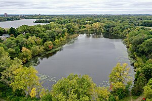
Cedar Lake is a lake in Minneapolis, Minnesota, United States, and part of the city's Chain of Lakes. It is located on the west side of the city, north of Bde Maka Ska and west of Lake of the Isles. The lake is surrounded by parkland, with some easements having been made to private homeowners on the southeast side; it is the only lake in the city with private shoreline.
Calhoun Isles, Minneapolis
Community of Minneapolis
Distance: Approx. 861 meters
Latitude and longitude: 44.9613,-93.3097
Calhoun-Isles, also called Bde Maka Ska-Isles, is one of the official communities (a grouping of several official neighborhoods) in the U.S. city of Minneapolis. It is split between Ward 7 and Ward 10 of the Minneapolis City Council, represented by councilmembers Katie Cashman and Aisha Chughtai, respectively. It contains the Uptown business district and the name "Uptown" is frequently (though somewhat incorrectly) used to refer to the entire community.

Cedar Lake East Beach
Natural beach in Minneapolis
Distance: Approx. 257 meters
Latitude and longitude: 44.96111111,-93.31833333
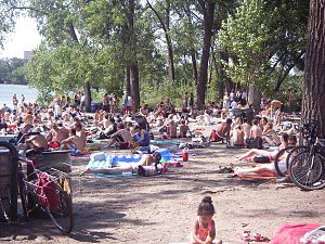
Cedar Lake East Beach is an urban beach in Minneapolis, Minnesota, United States. It is managed by the Minneapolis Park and Recreation Board and located on the east side of Cedar Lake. Known by most locals as "Hidden Beach", the area used to be obscured down a forested path, which contributed to its rise of prominence in the 1960s and 1970s as enclave of counter-culture.

Kenwood, Minneapolis
Neighborhood in Hennepin, Minnesota, United States
Distance: Approx. 798 meters
Latitude and longitude: 44.959,-93.3119
Kenwood is a neighborhood within the Calhoun-Isles community in Minneapolis along Lake of the Isles and Cedar Lake. The neighborhood is one of the most affluent in the city along with the nearby Lowry Hill neighborhood. The Kenwood neighborhood's most notable feature is the many historic mansions along the parkways overlooking the lake and the downtown skyline.
Bryn Mawr, Minneapolis
Neighborhood in Hennepin, Minnesota, United States
Distance: Approx. 1235 meters
Latitude and longitude: 44.9729,-93.3136
Bryn Mawr (pronounced from Welsh for "big hill") is a neighborhood within the Calhoun-Isles community in Minneapolis located directly west of downtown Minneapolis. It is in Ward 7, represented by council member Katie Cashman. Prior to the 1960s, the neighborhood was home to many workers of the nearby Minneapolis and St.
Cedar-Isles-Dean, Minneapolis
Neighborhood in Hennepin, Minnesota, United States
Distance: Approx. 983 meters
Latitude and longitude: 44.9541,-93.3214
Cedar-Isles-Dean is a neighborhood in the Calhoun-Isles community in Minneapolis. Its boundaries are the Kenilworth Lagoon and Lake of the Isles to the north and east, West Lake Street to the south, and France Avenue South to the west. It is in Ward 7, represented by council member Katie Cashman.

Frieda and Henry J. Neils House
Historic house in Minnesota, United States
Distance: Approx. 577 meters
Latitude and longitude: 44.95805556,-93.31777778
The Frieda and Henry J. Neils House is a house in Minneapolis designed by Frank Lloyd Wright. The home was designed for Henry J. Neils, a stone and architectural materials distributor, and his wife Frieda. It is unusual for a Wright-designed home both in the type of stone used as well as in its aluminum window framing.

Kenwood Park Water Tower
Stone water tower
Distance: Approx. 1197 meters
Latitude and longitude: 44.9675,-93.30666667
The Kenwood Park Water Tower is an octagonal brick and stone water tower in the Kenwood neighborhood of Minneapolis, Minnesota, United States. It was built in 1910 and designed by Frederick William Cappelen, the city of Minneapolis engineer at the time. The tower is 110 feet tall, making it the tallest structure in Kenwood.

Dr. Oscar Owre House
Historic house in Minnesota, United States
Distance: Approx. 1301 meters
Latitude and longitude: 44.95777778,-93.30555556
The Dr. Oscar Owre House is a historic house located at 2625 Newton Venue South just north of Lake of the Isles in Minneapolis, Minnesota. It was designed by notable local architects Purcell, Feick & Elmslie in the Prairie School style.

Kenilworth Trail
Shared-use path in Minneapolis
Distance: Approx. 687 meters
Latitude and longitude: 44.95805556,-93.315
The Kenilworth Trail is a paved bicycle trail in Minneapolis, Minnesota, United States. It runs nearly 1.5 miles (2.4 km) and acts as a connector between the Cedar Lake Trail in the north and the Midtown Greenway in the south. Like the Cedar Lake Trail, most of the route is composed of a triple-divided cycleway/pedway with a pair of one-way paths for bicycles and another path for pedestrians.

Paul Olfelt House
Distance: Approx. 1351 meters
Latitude and longitude: 44.9619,-93.3375
Paul Olfelt House is a Usonian style house designed by Frank Lloyd Wright in St. Louis Park, Minnesota, at the outskirts of Minneapolis. It was designed in 1958 and completed in 1960 as a residence for Paul and Helen Olfelt, who commissioned both the building and the interior design from the architect.

Brownie Lake
Lake in Minnesota
Distance: Approx. 603 meters
Latitude and longitude: 44.9675,-93.32444444
Brownie Lake is a lake in Hennepin County, Minnesota, and within the city limits of Minneapolis. It is the northernmost lake in the Minneapolis Chain of Lakes (Brownie Lake, Cedar Lake, Lake of the Isles, Bde Maka Ska, and Lake Harriet). It is within Brownie Lake Park, and administered by the Minneapolis Park and Recreation Board (MPRB).
Weather in this IP's area
light rain
7 Celsius
3 Celsius
6 Celsius
8 Celsius
1005 hPa
94 %
1005 hPa
974 hPa
10000 meters
5.14 m/s
340 degree
100 %
06:57:51
16:55:55


