Country:
Region:
City:
Latitude and Longitude:
Time Zone:
Postal Code:
IP information under different IP Channel
ip-api
Country
Region
City
ASN
Time Zone
ISP
Blacklist
Proxy
Latitude
Longitude
Postal
Route
Luminati
Country
ASN
Time Zone
America/Chicago
ISP
COMCAST-7725
Latitude
Longitude
Postal
IPinfo
Country
Region
City
ASN
Time Zone
ISP
Blacklist
Proxy
Latitude
Longitude
Postal
Route
db-ip
Country
Region
City
ASN
Time Zone
ISP
Blacklist
Proxy
Latitude
Longitude
Postal
Route
ipdata
Country
Region
City
ASN
Time Zone
ISP
Blacklist
Proxy
Latitude
Longitude
Postal
Route
Popular places and events near this IP address
WGHR (Georgia)
Radio station in Marietta, Georgia (1981–2004)
Distance: Approx. 3970 meters
Latitude and longitude: 33.939737,-84.519753
WGHR was a noncommercial radio station operated exclusively by the students of Southern Polytechnic State University in Marietta, Georgia, United States. The station was supported by students and its listeners to provide diverse programming and represent its community with a wide variety of musical genres.

Southern Polytechnic State University
Former state university in Marietta, Georgia, US
Distance: Approx. 3964 meters
Latitude and longitude: 33.94,-84.52
Southern Polytechnic State University (also called Southern Poly; abbreviated SPSU) was a public, co-educational, state university in Marietta, Georgia, United States approximately 20 miles (32 km) northwest of downtown Atlanta. Until 2015, it was an independent part of the University System of Georgia and called itself "Georgia's Technology University." Southern Tech was founded in 1948 as The Technical Institute in Chamblee, Georgia by Blake R. Van Leer. The first classes were held with 116 students.

Big Chicken
KFC restaurant in Marietta, Georgia
Distance: Approx. 3185 meters
Latitude and longitude: 33.9514,-84.5204
The Big Chicken is a KFC restaurant in Marietta, Georgia, which features a 56-foot-tall (17 m) steel-sided structure designed in the appearance of a chicken rising up from the top of the building. It is located at the intersection of Cobb Parkway (U.S. 41/Georgia 3) and Roswell Road (Georgia 120) and is a well-known landmark in the area. Constructed in 1963, it was rebuilt following storm damage in 1993 and underwent a $2 million renovation project in 2017.
Six Flags White Water
Water park in Cobb County, Georgia
Distance: Approx. 2963 meters
Latitude and longitude: 33.95805556,-84.52138889
Six Flags White Water is a 69-acre (280,000 m2) water park located northwest of Atlanta, in East Cobb, Georgia. Originally opening in 1984 as White Water Atlanta, the park became part of the Six Flags family of parks in 1999. Today, it is marketed as a second gate to Six Flags Over Georgia, and the two parks often cross-promote each other.

The Walker School
Private school in Marietta, Georgia, United States
Distance: Approx. 4196 meters
Latitude and longitude: 33.97,-84.536
The Walker School, formerly known as the Joseph T. Walker School, is a private school in Marietta, Georgia, United States, on Cobb Parkway (U.S. 41) in what was originally Sprayberry High School. It was founded in 1957 as the St. James Day School at St.

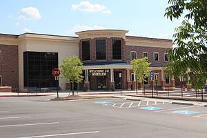
Wheeler High School (Georgia)
Public high school in Marietta, Georgia, United States
Distance: Approx. 1449 meters
Latitude and longitude: 33.958841,-84.477775
Wheeler High School is located in northeast Cobb County, Georgia, U.S. It is near the city of Marietta, about 15 miles (24 km) northwest of downtown Atlanta. The school has been in operation since 1965. It is a public high school, accredited by the Southern Association of Colleges and Schools.
Powers Park, Georgia
Unincorporated community in Georgia, U.S.
Distance: Approx. 3696 meters
Latitude and longitude: 33.93385556,-84.48123889
Powers Park is an unincorporated community located east-southeast of Marietta in Cobb County, Georgia, United States.
Marietta City Schools (Georgia)
School district in Georgia (U.S. state)
Distance: Approx. 3602 meters
Latitude and longitude: 33.956395,-84.528013
The Marietta City School District is the school district which operates the public schools in Marietta, Georgia, United States. It is the only city government in Cobb County which operates its schools separately from the Cobb County School District. Founded in 1892, classes began that year on Labor Day at four schools.

Sewell Mill Creek
Distance: Approx. 3275 meters
Latitude and longitude: 33.96277778,-84.45555556
Sewell Mill Creek is a tributary of Sope Creek in Marietta, Georgia, United States. Via Sope Creek and the Chattahoochee River, it is part of the Apalachicola River basin, draining to the Gulf of Mexico.
Southeastern Legal Foundation
US non-profit organization
Distance: Approx. 940 meters
Latitude and longitude: 33.9739,-84.4869
The Southeastern Legal Foundation is a conservative non-profit constitutional public interest law firm and policy center in the United States. It was founded in 1976 and has its headquarters in Roswell, Georgia.
Frobel-Knight-Borders House
United States historic place
Distance: Approx. 3197 meters
Latitude and longitude: 33.97527778,-84.52361111
The Frobel-Knight-Borders House is a historic house in Marietta, Georgia, U.S. It was built for a Confederate veteran, and it was later the private residence of Marietta's mayor. It is listed on the National Register of Historic Places.
Disappearance of Tiffany Whitton
Unsolved 2013 disappearance of 26 year-old American woman
Distance: Approx. 3606 meters
Latitude and longitude: 33.9464,-84.5218
In the early morning hours of September 13, 2013, Tiffany Whitton, (born January 30, 1987), of Powder Springs, Georgia, United States, was observed apparently shoplifting by loss prevention officers at a Walmart in nearby Marietta. They gathered to confront her at the store's exit, but after a brief struggle, she broke free and fled. She has not been seen since.
Weather in this IP's area
light rain
11 Celsius
10 Celsius
9 Celsius
12 Celsius
1020 hPa
84 %
1020 hPa
982 hPa
10000 meters
5.66 m/s
8.23 m/s
90 degree
100 %
07:09:06
17:35:45