50.219.165.29 - IP Lookup: Free IP Address Lookup, Postal Code Lookup, IP Location Lookup, IP ASN, Public IP
Country:
 USA
USARegion:
City:
Location:
Time Zone:
Postal Code:
ISP:
ASN:
language:
User-Agent:
Proxy IP:
Blacklist:
IP information under different IP Channel
ip-api
Country
Region
City
ASN
Time Zone
ISP
Blacklist
Proxy
Latitude
Longitude
Postal
Route
db-ip
Country
Region
City
ASN
Time Zone
ISP
Blacklist
Proxy
Latitude
Longitude
Postal
Route
IPinfo
Country
Region
City
ASN
Time Zone
ISP
Blacklist
Proxy
Latitude
Longitude
Postal
Route
IP2Location
50.219.165.29Country
usRegion
washington
City
longview
Time Zone
America/Los_Angeles
ISP
Language
User-Agent
Latitude
Longitude
Postal
ipdata
Country
Region
City
ASN
Time Zone
ISP
Blacklist
Proxy
Latitude
Longitude
Postal
Route
Popular places and events near this IP address

Mark Morris High School
Public secondary school in Longview, Washington, United States
Distance: Approx. 703 meters
Latitude and longitude: 46.14474,-122.93609
Mark Morris High School is a public high school in Longview, Washington, United States, for grades nine through twelve. In 2013, it had an enrollment of 976 students. A part of Longview Public Schools, the school was built in 1957 and is named for Samuel Mark Morris, the third president of the Long-Bell Lumber Company.

R. A. Long High School
Public school in Longview, Washington, United States
Distance: Approx. 1399 meters
Latitude and longitude: 46.141,-122.956
R. A. Long High School is the oldest high school serving the city of Longview, Washington. A part of Longview Public Schools, it was erected in 1927, three years after the city of Longview was incorporated. The total student enrollment at the end of the 2015–2016 school year was 890.
Lower Columbia College
Community college in Longview, Washington, US
Distance: Approx. 499 meters
Latitude and longitude: 46.14305556,-122.9375
Lower Columbia College (LCC) is a public community college in Longview, Washington. LCC offers associate degree programs along with some bachelor degree programs and certification courses. In the 2023-2024 year, LCC awarded 66 certificates, 491 associate degrees, and 5 Bachelor in Applied Science (BAS) degrees.

Monticello Hotel (Longview, Washington)
American historic former hotel
Distance: Approx. 168 meters
Latitude and longitude: 46.13944444,-122.94
The Monticello Hotel was a historic former landmark hotel and is a current apartment building in Longview, Washington. It was given to the city by founder R. A. Long in early 1923, and designed by Long's architects of choice, Hoit, Price, and Barnes, of Kansas City. Built between November 1922 and opening on July 14 of 1923, the "Hotel Monticello" was the first permanent building for the new planned city of Longview.

Nutty Narrows Bridge
Bridge for squirrels in Longview, Washington, U.S.
Distance: Approx. 360 meters
Latitude and longitude: 46.14138889,-122.94055556
The Nutty Narrows Bridge is a squirrel bridge in Longview, Washington, United States. It spans Olympia Way near R. A. Long Park in downtown Longview, comprising a 60 feet (18 m) catenary bridge with a center section resembling a suspension bridge. The bridge was built by local contractor Amos Peters in 1963 and named by a city councilwoman, in a likely nod to the Tacoma Narrows Bridge.

First Christian Church (Longview, Washington)
Historic church in Washington, United States
Distance: Approx. 996 meters
Latitude and longitude: 46.13138889,-122.94583333
First Christian Church is a historic church at 2000 E. Kessler Boulevard in Longview, Washington. It was built in 1930 and was added to the National Register in 1985.

Longview Community Church
Historic church in Washington, United States
Distance: Approx. 943 meters
Latitude and longitude: 46.13416667,-122.94861111
Longview Community Church is a historic church at 2323 Washington Way in Longview, Washington. It was built in 1925 and added to the National Register in 1985.
David Story Field
Sports venue in Longview, Washington, US
Distance: Approx. 494 meters
Latitude and longitude: 46.143,-122.939
Story Field at Lower Columbia College in Longview, Washington, US, was remodeled for the 2010 Cowlitz Black Bears' inaugural season. Amenities include party suites and the Bob's Sporting Goods Party Deck in left field, the Home Plate Club in the grandstand area and picnic tables and a children's playground sponsored by Kelso, Washington's Red Lion Inn. Story Field is a premier plating field in the West Coast League, a premier summer college baseball league, that is played during the summer.
Saint Rose de Viterbo Catholic Church
Church in Washington, United States
Distance: Approx. 1288 meters
Latitude and longitude: 46.1325111,-122.9523998
Saint Rose de Viterbo Catholic Church is a Roman Catholic church in Longview, Washington, United States dedicated to Rose of Viterbo. It is a part of Saint Rose Parish inside the Archdiocese of Seattle. The parish was established in 1927 to serve the catholic population of the city of Longview, which had been established in 1923.

PeaceHealth St. John Medical Center
Hospital in Washington, United States
Distance: Approx. 1418 meters
Latitude and longitude: 46.1427,-122.9556
PeaceHealth St. John Medical Center is a 256-bed hospital located in Longview, Washington. Opened in 1943, it is operated by the PeaceHealth System.
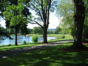
Lake Sacajawea (Longview, Washington)
Man-made lake in Cowlitz County, Washington
Distance: Approx. 1079 meters
Latitude and longitude: 46.137,-122.952
Lake Sacajawea is a man-made lake in Longview, Washington. It is named after the Shoshone woman named Sacajawea who guided Meriwether Lewis and William Clark during their expedition to the Pacific Ocean. The lake is made up of four sections, each separated by a bridged road.

Longview Women's Clubhouse
Historic women's clubhouse in Washington
Distance: Approx. 1046 meters
Latitude and longitude: 46.13194444,-122.94777778
The Longview Women's Clubhouse is a historic building in Longview, Washington. The building was completed in 1935 and was listed on the National Register of Historic Places in 1985 as part of a Multiple Property Submission.
Weather in this IP's area
broken clouds
-1 Celsius
-1 Celsius
-1 Celsius
1 Celsius
1010 hPa
97 %
1010 hPa
986 hPa
10000 meters
75 %