50.201.99.87 - IP Lookup: Free IP Address Lookup, Postal Code Lookup, IP Location Lookup, IP ASN, Public IP
Country:
 USA
USARegion:
City:
Location:
Time Zone:
Postal Code:
ISP:
ASN:
language:
User-Agent:
Proxy IP:
Blacklist:
IP information under different IP Channel
ip-api
Country
Region
City
ASN
Time Zone
ISP
Blacklist
Proxy
Latitude
Longitude
Postal
Route
db-ip
Country
Region
City
ASN
Time Zone
ISP
Blacklist
Proxy
Latitude
Longitude
Postal
Route
IPinfo
Country
Region
City
ASN
Time Zone
ISP
Blacklist
Proxy
Latitude
Longitude
Postal
Route
IP2Location
50.201.99.87Country
usRegion
new jersey
City
avenel
Time Zone
America/New_York
ISP
Language
User-Agent
Latitude
Longitude
Postal
ipdata
Country
Region
City
ASN
Time Zone
ISP
Blacklist
Proxy
Latitude
Longitude
Postal
Route
Popular places and events near this IP address
Avenel, New Jersey
Populated place in Middlesex County, New Jersey, US
Distance: Approx. 1220 meters
Latitude and longitude: 40.584334,-74.271626
Avenel is an unincorporated community and census-designated place (CDP) located within Woodbridge Township, in Middlesex County, in the U.S. state of New Jersey. Avenel is approximately 25 miles (40 km) southwest of Midtown Manhattan along the North Jersey Coast rail line As of the 2020 United States census, the CDP's population was 16,920, a decrease of 91 (−0.5%) from the 17,011 recorded at the 2010 census, which in turn had reflected a decline of 541 (−3.1%) from the 17,552 counted in the 2000 census.

Woodbridge Township, New Jersey
Township in Middlesex County, New Jersey, US
Distance: Approx. 2308 meters
Latitude and longitude: 40.56,-74.29
Woodbridge Township is a township in northern Middlesex County, in the U.S. state of New Jersey. The township is a regional hub of transportation and commerce for central New Jersey and a major bedroom suburb of New York City, within the New York metropolitan area. Located within the core of the Raritan Valley region, Woodbridge Township hosts the junction of the New Jersey Turnpike and the Garden State Parkway, the two busiest highways in the state, and also serves as the headquarters for the New Jersey Turnpike Authority, which operates both highways.
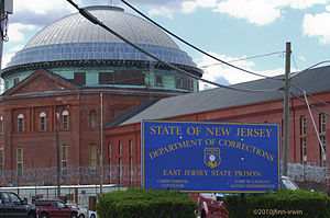
East Jersey State Prison
Medium-Security prison in New Jersey
Distance: Approx. 1926 meters
Latitude and longitude: 40.59130556,-74.26741667
East Jersey State Prison (formerly "Rahway State Prison") is a maximum security prison operated by the New Jersey Department of Corrections in Avenel, Woodbridge Township, New Jersey. It was established in 1896 as Rahway State Prison, and was the first reformatory in New Jersey, officially opening in 1901. It housed 1,227 inmates as of 2020.

Adult Diagnostic and Treatment Center
Distance: Approx. 1433 meters
Latitude and longitude: 40.59,-74.2738
The Adult Diagnostic and Treatment Center (ADTC) is a secure correctional facility operated by the New Jersey Department of Corrections. Its purpose is to provide treatment and incarceration for certain criteria meeting repetitive and compulsive male sex offenders who have been sentenced under the New Jersey Sex Offender Act. From its opening in 1976 through at least 1994, ADTC is a unique facility, the "only complex of its kind in the nation devoted exclusively to the treatment of adult sexual offenders".
Woodbridge High School (New Jersey)
High school in Middlesex County, New Jersey, US
Distance: Approx. 1554 meters
Latitude and longitude: 40.566448,-74.284695
Woodbridge High School is a four-year comprehensive public high school located in Woodbridge Township, in Middlesex County, New Jersey, serving students in ninth through twelfth grades as part of the Woodbridge Township School District. The high school is one of three in the district, together with Colonia High School and John F. Kennedy Memorial High School. The school is accredited until July 2025 and has been accredited by the Middle States Association of Colleges and Schools Commission on Elementary and Secondary Schools since 1928.

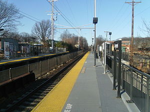
Avenel station
NJ Transit rail station
Distance: Approx. 698 meters
Latitude and longitude: 40.57843333,-74.27726111
Avenel is an active commuter railroad station in the Avenel section of Woodbridge Township, Middlesex County, New Jersey. Servicing trains of NJ Transit's North Jersey Coast Line, the station serves trains going to Long Branch and Bay Head to New York Penn Station. Avenel station serves as the first (going south) and last (going north) stop of standalone North Jersey Coast Line service, with the line merging into the Northeast Corridor Line at Rahway.
John F. Kennedy Memorial High School (New Jersey)
High school in Middlesex County, New Jersey, US
Distance: Approx. 1958 meters
Latitude and longitude: 40.57311,-74.306177
John F. Kennedy Memorial High School (J.F.K.) is one of three four-year comprehensive public high schools that serve students in ninth through twelfth grades from Woodbridge Township in Middlesex County, in the U.S. state of New Jersey, operating as part of the Woodbridge Township School District. The other two high schools in the district are Colonia High School and Woodbridge High School. The school has been accredited by the Middle States Association of Colleges and Schools Commission on Elementary and Secondary Schools since 1968 and expires in July 2026; In Fall 2018, the school's accreditation status was extended for seven years.

First Presbyterian Church and Cemetery
Historic church in New Jersey, United States
Distance: Approx. 2311 meters
Latitude and longitude: 40.56166667,-74.27333333
The First Presbyterian Church is located at 600 Rahway Avenue in Woodbridge Township of Middlesex County, New Jersey, United States. The congregation was founded in 1675. The main part of the church building was completed in 1803.

Trinity Episcopal Church (Woodbridge, New Jersey)
Historic church in New Jersey, United States
Distance: Approx. 2293 meters
Latitude and longitude: 40.56194444,-74.27305556
Trinity Episcopal Church is a historic church located at 650 Rahway Avenue in Woodbridge Township of Middlesex County, New Jersey. The third church at this location, it was added to the National Register of Historic Places on May 12, 2004, for its significance in architecture and religion.
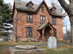
Jonathan Singletary Dunham House
Historic house in New Jersey, United States
Distance: Approx. 2098 meters
Latitude and longitude: 40.56416667,-74.2725
Jonathan Singletary Dunham House, located in Woodbridge Township in Middlesex County, New Jersey, the state's first township, chartered on June 1, 1669, by King Charles II, is a house that was built around 1709 by Jonathan Singletary Dunham (January 17, 1640 – September 6, 1724), an early American settler and freeholder who built the first gristmill in New Jersey nearby the house. Jonathan Dunham was born in Newbury, Massachusetts and married Mary Bloomfield with whom he later moved to present day New Jersey. Bloomfield is a relative of Joseph Bloomfield, Governor of New Jersey, for whom the township of Bloomfield, New Jersey is named.
Edgars, New Jersey
Populated place in Middlesex County, New Jersey, US
Distance: Approx. 1636 meters
Latitude and longitude: 40.5675,-74.27583333
Edgars or Edgar is an unincorporated community located within Woodbridge Township in Middlesex County, in the U.S. state of New Jersey. It approximately includes the area around Woodbridge High School over to Rahway Avenue, south of the Port Reading Railroad. The upper section of Ridgedale Avenue is known as Edgar's Hill.
Special Treatment Unit
Distance: Approx. 1800 meters
Latitude and longitude: 40.5908,-74.2688
The Special Treatment Unit is a facility in which civilly committed sex offenders are held, pursuant to the New Jersey Sexually Violent Predator Act of 1998 (N.J.S.A. 30:4-27.24 to -27.38). It is operated by the New Jersey Department of Corrections, and is located in a separate building within East Jersey State Prison in Avenel, New Jersey. It is near the Adult Diagnostic and Treatment Center, New Jersey's center for incarcerated sex offenders, also in Avenel.
Weather in this IP's area
clear sky
3 Celsius
-1 Celsius
2 Celsius
5 Celsius
1028 hPa
47 %
1028 hPa
1025 hPa
10000 meters
6.17 m/s
11.32 m/s
310 degree