Country:
Region:
City:
Latitude and Longitude:
Time Zone:
Postal Code:
IP information under different IP Channel
ip-api
Country
Region
City
ASN
Time Zone
ISP
Blacklist
Proxy
Latitude
Longitude
Postal
Route
Luminati
Country
Region
ca
City
fortbragg
ASN
Time Zone
America/Los_Angeles
ISP
AS-SONICTELECOM
Latitude
Longitude
Postal
IPinfo
Country
Region
City
ASN
Time Zone
ISP
Blacklist
Proxy
Latitude
Longitude
Postal
Route
db-ip
Country
Region
City
ASN
Time Zone
ISP
Blacklist
Proxy
Latitude
Longitude
Postal
Route
ipdata
Country
Region
City
ASN
Time Zone
ISP
Blacklist
Proxy
Latitude
Longitude
Postal
Route
Popular places and events near this IP address

Fort Bragg, California
City in California, United States
Distance: Approx. 77 meters
Latitude and longitude: 39.4457,-123.8044
Fort Bragg is a city along the North Coast of California in Mendocino County. The city is 24 miles (39 km) west of Willits, at an elevation of 85 feet (26 m). Its population was 6,983 at the 2020 census.

California Western Railroad
Heritage railroad in Mendocino County, California, US
Distance: Approx. 131 meters
Latitude and longitude: 39.4455,-123.8068
The California Western Railroad (reporting mark CWR), AKA Mendocino Railway, popularly called the Skunk Train, is a rail freight and heritage railroad transport railway in Mendocino County, California, United States, running from the railroad's headquarters in the coastal town of Fort Bragg to the interchange with the Northwestern Pacific Railroad at Willits. The CWR runs steam- and diesel-powered trains and rail motor cars through Redwood forests along Pudding Creek and the Noyo River. Along the way, the tracks cross some 30 single bridges and trestles and pass through two deep mountain tunnels.

Noyo River
River in Mendocino County, California (USA) with its mouth at Fort Bragg
Distance: Approx. 2023 meters
Latitude and longitude: 39.42777778,-123.80916667
The Noyo River (Pomo: Chemli-bida) is a river on the north coast of California in Mendocino County. The river's headwaters are in the steep Mendocino Range, but downstream the river flows through gently sloping marine terraces before draining into the Pacific Ocean. The 113 square miles (290 km2) watershed extends east to the small city of Willits and the river's mouth is at Noyo Harbor in Fort Bragg, which uses the river for drinking water; it is neighbored on the south by Hare Creek and the Big River, on the east by the South Fork Eel River, and on the north by Ten Mile River, named for its distance from the Noyo River.

North Coast Brewing Company
Craft brewery in Fort Bragg, California (USA)
Distance: Approx. 118 meters
Latitude and longitude: 39.4465,-123.8062
The North Coast Brewing Company is a craft brewery located in Fort Bragg, California. As of 2018, it is the 46th-largest craft brewer by annual sales volume in the United States.

Fort Bragg High School
Public secondary school in Fort Bragg, California (United States)
Distance: Approx. 1713 meters
Latitude and longitude: 39.4378,-123.7882
Fort Bragg High School is the comprehensive public high school in Fort Bragg, California, United States, responsible for offering the ninth through twelfth grades to students in the Fort Bragg Unified School District. The school serves a remote area of Mendocino County, its service boundary containing 14,689 residents living in an area of greater than 251 square miles as of the 2010 census. In addition to Fort Bragg, the school district, of which this is the sole comprehensive high school, includes Cleone.

Noyo Harbor
Harbor in Fort Bragg, California
Distance: Approx. 2420 meters
Latitude and longitude: 39.424,-123.8037
Noyo Harbor is the port and boat docking area for Fort Bragg, California, USA. It is built near the mouth of the Noyo River in the town of Noyo, just south of Fort Bragg. Noyo Harbor is located in Mendocino County 130 nautical miles (240 km) northwest of the Port of San Francisco and 145 nautical miles (269 km) south-southeast of the port of Crescent City, California. Highway 1 passes over the Noyo Bridge above the harbor.
KDAC
Radio station in Fort Bragg, California
Distance: Approx. 2110 meters
Latitude and longitude: 39.443,-123.781
KDAC (1230 AM) is a radio station broadcasting a classic hits format, simulcasting KUKI 1400 AM Ukiah. Licensed to Fort Bragg, California, United States.

Glass Beach (Fort Bragg, California)
Beach in northern California, USA
Distance: Approx. 1105 meters
Latitude and longitude: 39.45361111,-123.81305556
Glass Beach is a beach adjacent to MacKerricher State Park near Fort Bragg, California, named from a time when it was abundant with sea glass created from years of dumping garbage into an area of coastline near the northern part of the town.

Noyo, California
Unincorporated community in California, United States
Distance: Approx. 1941 meters
Latitude and longitude: 39.42833333,-123.80333333
Noyo (formerly, "Noyo River") is an unincorporated community in Mendocino County, California. It is located 1 mile (1.6 km) south of the center of Fort Bragg, at an elevation of 108 feet (33 m). It is named after the Noyo River, on which it lies; the Noyo River in turn was misnamed by white settlers to the Mendocino area after a village of the Pomo people named Noyo several miles north, on Pudding Creek.

Weller House (Fort Bragg, California)
Historic house in California, United States
Distance: Approx. 242 meters
Latitude and longitude: 39.44741,-123.80703
The Weller House, located at 524 Stewart Street in Fort Bragg, California, is a historic Victorian house that is operating as a bed & breakfast. The oldest building in the city, it was built in 1886 for Horace Alanson Weller Sr., a prominent figure in the early history of Fort Bragg who was manager of the Union Lumber Company Store then co-founder of the town's first bank. Expanded a year later, it came to include three stories with 10 rooms totaling 10,000 square feet (930 m2), including a 900 square feet (84 m2) ballroom.

Fort Bragg Unified School District
School district in Mendocino County, Calif
Distance: Approx. 1175 meters
Latitude and longitude: 39.4385,-123.7953
Fort Bragg Unified School District, a public school district in Mendocino County, oversees public primary and secondary education in Fort Bragg, California and the surrounding area, accountable to both the local voters and the California Department of Education. It was organized in 1895, shortly before the town formally incorporated, for the families of the fast-growing number of men moving to the area to work for Union Lumber Company or one of the other local lumber mills during the logging boom of the late 19th century. Most students are served by the district's two secondary schools, two primary schools and transitional kindergarten, none of which have overlapping grade offerings.

Noyo River Bridge
Bridge in Fort Bragg, California, United States
Distance: Approx. 2052 meters
Latitude and longitude: 39.4273,-123.8068
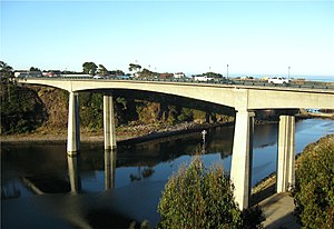
The Noyo River Bridge is a box girder bridge constructed of prestressed concrete crossing the Noyo River in Fort Bragg, California. Owned and maintained by the California Department of Transportation, it carries motor vehicle, bicycle and pedestrian traffic over the waterway as part of California State Route 1, which is also signed as Main Street within the Fort Bragg city limits. Construction on the current bridge began in 2002 and was completed in August 2005, now the sixth such structure to span the river near its mouth and bear the name Noyo River Bridge, replacing a two-lane steel deck truss bridge built in 1948.
Weather in this IP's area
light rain
11 Celsius
11 Celsius
10 Celsius
13 Celsius
1018 hPa
95 %
1018 hPa
1015 hPa
10000 meters
0.75 m/s
2.23 m/s
175 degree
31 %
06:57:39
17:01:45