Country:
 USA
USARegion:
City:
Latitude and Longitude:
Time Zone:
Postal Code:
IP information under different IP Channel
ip-api
Country
Region
City
ASN
Time Zone
ISP
Blacklist
Proxy
Latitude
Longitude
Postal
Route
IPinfo
Country
Region
City
ASN
Time Zone
ISP
Blacklist
Proxy
Latitude
Longitude
Postal
Route
MaxMind
Country
Region
City
ASN
Time Zone
ISP
Blacklist
Proxy
Latitude
Longitude
Postal
Route
Luminati
Country
USRegion
ca
City
walnutcreek
ASN
Time Zone
America/Los_Angeles
ISP
AS-SONICTELECOM
Latitude
Longitude
Postal
db-ip
Country
Region
City
ASN
Time Zone
ISP
Blacklist
Proxy
Latitude
Longitude
Postal
Route
ipdata
Country
Region
City
ASN
Time Zone
ISP
Blacklist
Proxy
Latitude
Longitude
Postal
Route
Popular places and events near this IP address

Walnut Creek, California
City in California, United States
Distance: Approx. 625 meters
Latitude and longitude: 37.90638889,-122.065
Walnut Creek is a city in Contra Costa County, California, United States, located in the East Bay region of the San Francisco Bay Area, about 16 miles (26 kilometers) east of the city of Oakland. Walnut Creek has a total population of 70,127 per the 2020 census, is located at the junction of the highways from Sacramento and San Jose (I-680) and San Francisco/Oakland (SR-24), and is accessible by BART. The city shares its borders with Clayton, Lafayette, Alamo, Pleasant Hill, and Concord.

Gardens at Heather Farm
Distance: Approx. 2126 meters
Latitude and longitude: 37.91888889,-122.04277778
The 6-acre (2.4 ha) Gardens at Heather Farm are a set of gardens located at Heather Farm Park in Walnut Creek, California, United States. The gardens have a view of Mount Diablo, and are open to the public 7 days a week during daylight hours.
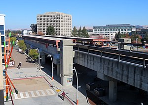
Walnut Creek station
Rapid transit station in San Francisco Bay Area
Distance: Approx. 800 meters
Latitude and longitude: 37.905724,-122.067332
Walnut Creek station is an elevated Bay Area Rapid Transit (BART) station in Walnut Creek, California, served by the Yellow Line. The station is located north of downtown Walnut Creek, adjacent to Interstate 680 and near the Ygnacio Valley Road and California Boulevard arterial roads.
Las Lomas High School
Public school in Walnut Creek, California, United States
Distance: Approx. 1476 meters
Latitude and longitude: 37.89111111,-122.05666667
Las Lomas High School (LLHS) is a public high school in Walnut Creek, California, United States. It was founded in 1951 by the Acalanes Union High School District, and opened its doors in the fall of 1952 to its first graduating class. Las Lomas was the second of five schools built within the Acalanes Union High School District.
Rancho San Miguel
Distance: Approx. 2455 meters
Latitude and longitude: 37.91361111,-122.03305556
Rancho San Miguel is a neighborhood in Walnut Creek, California. It is named after the Alta California Rancho Rancho Arroyo de Las Nueces y Bolbones which was also referred to as Rancho San Miguel. Until the mid-1950s the area consisted largely of walnut orchards, until developer Joseph Eichler built a subdivision north of Shell Ridge and Ygnacio Valley Road.
Acalanes Ridge, California
Census-designated place in California, United States
Distance: Approx. 1776 meters
Latitude and longitude: 37.90472222,-122.07861111
Acalanes Ridge is a census-designated place in Contra Costa County, California. Acalanes Ridge sits at an elevation of 499 feet (152 m). The population was 1,285 at the 2020 Census.
Shell Ridge, California
Census-designated place in California, United States
Distance: Approx. 2111 meters
Latitude and longitude: 37.90583333,-122.03444444
Shell Ridge is a census-designated place in Contra Costa County, California, United States. Shell Ridge sits at an elevation of 295 feet (90 m). The 2010 United States census reported Shell Ridge's population was 959.
Mount Diablo Unitarian Universalist Church
Church in CA, USA
Distance: Approx. 1224 meters
Latitude and longitude: 37.89968,-122.04575
Mount Diablo Unitarian Universalist Church (MDUUC) is a church in Walnut Creek, California. In 2016, it claimed a membership of 494. The church buildings occupy a 14-acre tract at 55 Eckley Lane in Walnut Creek.
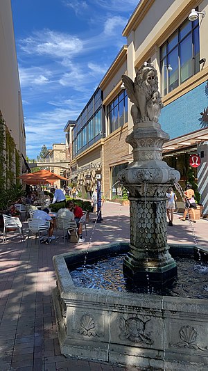
Broadway Plaza (Walnut Creek)
Shopping mall in California, United States
Distance: Approx. 980 meters
Latitude and longitude: 37.89551,-122.05786
Broadway Plaza is an outdoor shopping mall located in downtown Walnut Creek. The shopping center opened on October 11, 1951 and is owned and operated by Macerich. The mall is anchored by Nordstrom and Macy's, and features nearly 80 stores including Crate & Barrel, flagship H&M and ZARA stores, a standalone Apple store with an adjoining outdoor plaza, an Industrious co-working space, a Life Time Fitness sports club, and a planned Pinstripes entertainment center and restaurant.

Heather Farm Park
Distance: Approx. 2202 meters
Latitude and longitude: 37.92027778,-122.04361111
Heather Farm Park is a 102-acre community park in Walnut Creek, California. It contains the Gardens at Heather Farm, a swimming pool, inclusive playground, sports fields, equestrian center, dog park, fishing pond, nature area, lake, and other amenities.

Las Trampas Creek
River in California, United States
Distance: Approx. 1140 meters
Latitude and longitude: 37.8941,-122.0596
Las Trampas Creek is a 12.37 mile (19.9 km) long north-east flowing stream in Contra Costa County, California. Its watershed comprises an area of 17,238 acres. Its mean daily flow is approximately 15.4 cfs.

Tice Creek
River
Distance: Approx. 1132 meters
Latitude and longitude: 37.89416667,-122.05944444
Tice Creek is a minor creek in Contra Costa County, California in the San Francisco Bay Area. It is approximately 4.1 miles (6.6 km) long. It is a tributary of Las Trampas Creek, which itself is a major tributary to Walnut Creek which in turn drains into Suisun Bay.
Weather in this IP's area
clear sky
23 Celsius
23 Celsius
17 Celsius
27 Celsius
1010 hPa
56 %
1010 hPa
1006 hPa
10000 meters
5.66 m/s
270 degree
06:53:57
19:09:45