Country:
Region:
City:
Latitude and Longitude:
Time Zone:
Postal Code:
IP information under different IP Channel
ip-api
Country
Region
City
ASN
Time Zone
ISP
Blacklist
Proxy
Latitude
Longitude
Postal
Route
Luminati
Country
Region
ca
City
sanfrancisco
ASN
Time Zone
America/Los_Angeles
ISP
AS-SONICTELECOM
Latitude
Longitude
Postal
IPinfo
Country
Region
City
ASN
Time Zone
ISP
Blacklist
Proxy
Latitude
Longitude
Postal
Route
db-ip
Country
Region
City
ASN
Time Zone
ISP
Blacklist
Proxy
Latitude
Longitude
Postal
Route
ipdata
Country
Region
City
ASN
Time Zone
ISP
Blacklist
Proxy
Latitude
Longitude
Postal
Route
Popular places and events near this IP address

George Washington High School (San Francisco)
School in San Francisco, California, United States
Distance: Approx. 672 meters
Latitude and longitude: 37.77781389,-122.49201111
George Washington High School is a public high school in the Richmond District of San Francisco, California. The campus occupies the highest ground in the neighborhood, south of Geary Boulevard between 30th and 32nd Avenues, with a sweeping view of the Golden Gate Bridge from the athletic fields. Presidio Middle School, also a public school, is located kitty-corner to the campus.
Lincoln Park (San Francisco)
Park in California, United States
Distance: Approx. 670 meters
Latitude and longitude: 37.78388889,-122.50277778
Lincoln Park is a park in San Francisco, California. It was dedicated to President Abraham Lincoln in 1909 and includes about 100 acres (0.4 km2) of the northwestern corner of the San Francisco Peninsula. Lincoln Park park hosts the Legion of Honor Museum of art and is the western terminus of the Lincoln Highway, the first automobile roadway across the United States of America.
Katherine Delmar Burke School
Private school in San Francisco
Distance: Approx. 240 meters
Latitude and longitude: 37.78361111,-122.4925
Katherine Delmar Burke School, commonly known as Burke's, is an independent girls' school for kindergarten through eighth grade, located in the Sea Cliff neighborhood of San Francisco, California, United States, near Lincoln Park. Until 1975 it also included a high school. It was founded in 1908 by Katherine Delmar Burke and was named Miss Burke's School.

Fort Miley Military Reservation
Distance: Approx. 919 meters
Latitude and longitude: 37.78214444,-122.50554167
The Fort Miley Military Reservation, in San Francisco, California, sits on Point Lobos (not to be confused with Point Lobos near Carmel-by-the-Sea), one of the outer headlands on the southern side of the Golden Gate. Much of the site is part of the Golden Gate National Recreation Area, while the grounds and buildings that were converted into the San Francisco VA Medical Center are administered by the Veterans Health Administration of the US Department of Veterans Affairs.

China Beach, San Francisco
Small cove in San Francisco, California
Distance: Approx. 541 meters
Latitude and longitude: 37.7878821,-122.4931363
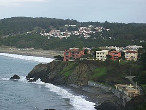
China Beach is a small cove in San Francisco's Sea Cliff neighborhood. It lies between Baker Beach and Lands End and is part of the Golden Gate National Recreation Area. It was once used as a campsite for Chinese fishermen who anchored their boats in the cove.

Holocaust Memorial at California Palace of the Legion of Honor
Holocaust memorial by George Segal in San Francisco, California, U.S.
Distance: Approx. 512 meters
Latitude and longitude: 37.78444444,-122.50083333
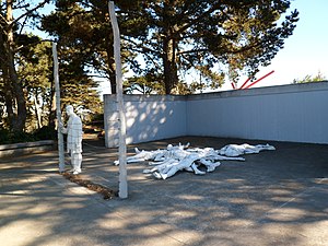
The Holocaust Memorial at California Palace of the Legion of Honor is a Holocaust memorial in San Francisco, California, in Lincoln Park, overlooking the Golden Gate. It was created by artist George Segal out of white painted bronze. In 1981, the city invited Segal to submit a design for its competition; his plaster maquette is held by the Jewish Museum in New York.

Sea Cliff, San Francisco
Neighborhood of San Francisco
Distance: Approx. 676 meters
Latitude and longitude: 37.78752222,-122.48968333
Sea Cliff (sometimes spelled Seacliff) is a neighborhood in northwestern San Francisco, California. It is known for its large houses and ocean views. Sea Cliff is one of eight master–planned residence parks in San Francisco; its master plan was developed by landscape architect Mark Daniels.

San Francisco VA Medical Center
Distance: Approx. 858 meters
Latitude and longitude: 37.78227778,-122.50486111
The San Francisco VA Medical Center, also called the San Francisco Veterans Affairs Medical Center or the SFVAMC, is a Veterans Affairs medical center, located in San Francisco. The main facility is on 42nd Avenue and Clement Street at the former Fort Miley Military Reservation in the Richmond District. Fort Miley is located south of the Golden Gate and west of the San Francisco Presidio, on Point Lobos (San Francisco) surrounded by the Golden Gate National Recreation Area.

Holy Virgin Cathedral
Russian Orthodox cathedral in San Francisco
Distance: Approx. 851 meters
Latitude and longitude: 37.780425,-122.48623611
The Holy Virgin Cathedral, also known as Joy of All Who Sorrow (Russian: Радосте-Скорбященский собор), is a Russian Orthodox cathedral in the Richmond District of San Francisco. It is the largest of the six cathedrals of the Russian Orthodox Church Outside Russia, which has over 400 parishes worldwide, and the cathedra of the Diocese of San Francisco and Western America.

Lincoln Manor
Distance: Approx. 383 meters
Latitude and longitude: 37.78055556,-122.49783333
Lincoln Manor is one of the master-planned residence parks in the western neighborhoods of San Francisco, with the others including Sea Cliff, St. Francis Wood, Presidio Terrace, West Clay Park, Forest Hill, Balboa Terrace, Ingleside Terraces, and Jordan Park. Lincoln Manor, established in 1914, is located within the Richmond District, in the Northwest portion of San Francisco.
Lincoln Heights (San Francisco)
Distance: Approx. 423 meters
Latitude and longitude: 37.7822,-122.4998
Lincoln Heights is the 24th highest peak in the city of San Francisco, California, at 380 feet. Situated in the northwestestern portion of the city, the hill has the Legion of Honor museum near its peak. Notable features include the Lincoln Park golf course, the Lands End trail system, and some residential neighborhoods in the Richmond District.

Golden Gate Cemetery (San Francisco, California)
American cemetery in San Francisco (1870–1900)
Distance: Approx. 583 meters
Latitude and longitude: 37.7852,-122.50138
Golden Gate Cemetery, also called the City Cemetery, and Potter's Field, was a burial ground with 29,000 remains, active between 1870 and approximately 1909 and was located in San Francisco, California. The site of this former cemetery is now Lincoln Park and the Legion of Honor museum.
Weather in this IP's area
broken clouds
18 Celsius
17 Celsius
16 Celsius
21 Celsius
1015 hPa
43 %
1015 hPa
1005 hPa
10000 meters
1.79 m/s
4.47 m/s
290 degree
77 %
06:44:30
17:03:20
